Rous County
Map all coordinates using OpenStreetMap
Download coordinates as:
- KML
- GPX (all coordinates)
- GPX (primary coordinates)
- GPX (secondary coordinates)
Cadastral in New South Wales, Australia
| Rous New South Wales | |||||||||||||||
|---|---|---|---|---|---|---|---|---|---|---|---|---|---|---|---|
 Location in New South Wales | |||||||||||||||
| |||||||||||||||
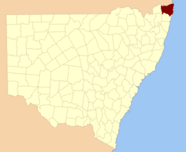
Rous County is one of the 141 cadastral divisions of New South Wales. It is located at the north-east tip of the state. It is bordered on the north by the border with Queensland and on the south by the Richmond River. It contains Lismore, Byron Bay and Murwillumbah.
Rous County was named in honour of Admiral Henry John Rous (1795-1877).[1]
Parishes within this county
A full list of parishes found within this county; their current LGA and mapping coordinates to the approximate centre of each location is as follows:
| Parish | LGA | Coordinates |
|---|---|---|
| Babyil | Kyogle Shire | 28°37′54″S 152°45′04″E / 28.63167°S 152.75111°E / -28.63167; 152.75111 (Babyil Parish) |
| Ballina | Ballina Shire | 28°49′54″S 153°33′04″E / 28.83167°S 153.55111°E / -28.83167; 153.55111 (Ballina Parish) |
| Berwick | Tweed Shire | 28°13′54″S 153°25′04″E / 28.23167°S 153.41778°E / -28.23167; 153.41778 (Berwick Parish) |
| Bexhill | City of Lismore | 28°45′54″S 153°22′04″E / 28.76500°S 153.36778°E / -28.76500; 153.36778 (Bexhill Parish) |
| Billinudgel | Tweed Shire | 28°30′54″S 153°30′04″E / 28.51500°S 153.50111°E / -28.51500; 153.50111 (Billinudgel Parish) |
| Bingal | Ballina Shire | 28°56′54″S 153°28′04″E / 28.94833°S 153.46778°E / -28.94833; 153.46778 (Bingal Parish) |
| Blakebrook | City of Lismore | 28°45′54″S 153°16′04″E / 28.76500°S 153.26778°E / -28.76500; 153.26778 (Blakebrook Parish) |
| Boorabee | City of Lismore | 28°39′54″S 153°05′04″E / 28.66500°S 153.08444°E / -28.66500; 153.08444 (Boorabee Parish) |
| Broadwater | City of Lismore | 29°00′54″S 153°24′04″E / 29.01500°S 153.40111°E / -29.01500; 153.40111 (Broadwater Parish) |
| Brunswick | Byron Shire | 28°35′54″S 153°31′04″E / 28.59833°S 153.51778°E / -28.59833; 153.51778 (Brunswick Parish) |
| Bungabbee | City of Lismore | 28°43′54″S 153°08′04″E / 28.73167°S 153.13444°E / -28.73167; 153.13444 (Bungabbee Parish) |
| Burrell | Kyogle Shire | 28°23′54″S 153°15′04″E / 28.39833°S 153.25111°E / -28.39833; 153.25111 (Burrell Parish) |
| Byron | Byron Shire | 28°39′54″S 153°32′04″E / 28.66500°S 153.53444°E / -28.66500; 153.53444 (Byron Parish) |
| Chillingham | Kyogle Shire | 28°16′54″S 153°13′04″E / 28.28167°S 153.21778°E / -28.28167; 153.21778 (Chillingham Parish) |
| Clunes | City of Lismore | 28°40′54″S 153°25′04″E / 28.68167°S 153.41778°E / -28.68167; 153.41778 (Clunes Parish) |
| Condong | Tweed Shire | 28°19′54″S 153°27′04″E / 28.33167°S 153.45111°E / -28.33167; 153.45111 (Condong Parish) |
| Coraki | City of Lismore | 29°00′54″S 153°19′04″E / 29.01500°S 153.31778°E / -29.01500; 153.31778 (Coraki Parish) |
| Cougal | Kyogle Shire | 28°22′54″S 152°57′04″E / 28.38167°S 152.95111°E / -28.38167; 152.95111 (Cougal Parish) |
| Cudgen | Tweed Shire | 28°16′54″S 153°33′04″E / 28.28167°S 153.55111°E / -28.28167; 153.55111 (Cudgen Parish) |
| Dunbible | Tweed Shire | 28°22′54″S 153°23′04″E / 28.38167°S 153.38444°E / -28.38167; 153.38444 (Dunbible Parish) |
| Dunoon | City of Lismore | 28°39′54″S 153°19′04″E / 28.66500°S 153.31778°E / -28.66500; 153.31778 (Dunoon Parish) |
| Dyraaba | Kyogle Shire | 28°47′54″S 152°47′04″E / 28.79833°S 152.78444°E / -28.79833; 152.78444 (Dyraaba Parish) |
| East Gundurimba | City of Lismore | 28°51′54″S 153°18′04″E / 28.86500°S 153.30111°E / -28.86500; 153.30111 (East Gundurimba Parish) |
| Ettrick | Kyogle Shire | 28°34′54″S 152°52′04″E / 28.58167°S 152.86778°E / -28.58167; 152.86778 (Ettrick Parish) |
| Fairy Mount | Kyogle Shire | 28°33′54″S 153°03′04″E / 28.56500°S 153.05111°E / -28.56500; 153.05111 (Fairy Mount Parish) |
| Findon | Kyogle Shire | 28°22′54″S 152°51′04″E / 28.38167°S 152.85111°E / -28.38167; 152.85111 (Findon Parish) |
| Geneva | Kyogle Shire | 28°36′54″S 152°57′04″E / 28.61500°S 152.95111°E / -28.61500; 152.95111 (Geneva Parish) |
| Gooninbar | Kyogle Shire | 28°29′54″S 153°16′04″E / 28.49833°S 153.26778°E / -28.49833; 153.26778 (Gooninbar Parish) |
| Hanging Rock | City of Lismore | 28°31′54″S 153°08′04″E / 28.53167°S 153.13444°E / -28.53167; 153.13444 (Hanging Rock Parish) |
| Jasper | Byron Shire | 28°36′54″S 153°26′04″E / 28.61500°S 153.43444°E / -28.61500; 153.43444 (Jasper Parish) |
| Jiggi | City of Lismore | 28°36′54″S 153°08′04″E / 28.61500°S 153.13444°E / -28.61500; 153.13444 (Jiggi Parish) |
| Kunghur | Tweed Shire | 28°27′54″S 153°12′04″E / 28.46500°S 153.20111°E / -28.46500; 153.20111 (Kunghur Parish) |
| Kynnumboon | Tweed Shire | 28°16′54″S 153°20′04″E / 28.28167°S 153.33444°E / -28.28167; 153.33444 (Kynnumboon Parish) |
| Kyogle Shire | Richmond Valley Council | 28°45′54″S 153°00′04″E / 28.76500°S 153.00111°E / -28.76500; 153.00111 (Kyogle Shire Parish) |
| Langwell | Kyogle Shire | 28°38′54″S 152°51′04″E / 28.64833°S 152.85111°E / -28.64833; 152.85111 (Langwell Parish) |
| Lismore | City of Lismore | 28°49′54″S 153°23′04″E / 28.83167°S 153.38444°E / -28.83167; 153.38444 (Lismore Parish) |
| Loadstone | Kyogle Shire | 28°25′54″S 152°57′04″E / 28.43167°S 152.95111°E / -28.43167; 152.95111 (Loadstone Parish) |
| Meerschaum | Ballina Shire | 28°53′54″S 153°24′04″E / 28.89833°S 153.40111°E / -28.89833; 153.40111 (Meerschaum Parish) |
| Mooball | Tweed Shire | 28°24′54″S 153°29′04″E / 28.41500°S 153.48444°E / -28.41500; 153.48444 (Mooball Parish) |
| Mullumbimby | Byron Shire | 28°31′54″S 153°26′04″E / 28.53167°S 153.43444°E / -28.53167; 153.43444 (Mullumbimby Parish) |
| Mummulgum | Kyogle Shire | 28°52′54″S 152°47′04″E / 28.88167°S 152.78444°E / -28.88167; 152.78444 (Mummulgum Parish) |
| Murwillumbah | Tweed Shire | 28°19′54″S 153°17′04″E / 28.33167°S 153.28444°E / -28.33167; 153.28444 (Murwillumbah Parish) |
| Newrybar | Ballina Shire | 28°44′54″S 153°33′04″E / 28.74833°S 153.55111°E / -28.74833; 153.55111 (Newrybar Parish) |
| Nimbin | City of Lismore | 28°37′54″S 153°14′04″E / 28.63167°S 153.23444°E / -28.63167; 153.23444 (Nimbin Parish) |
| North Casino | Richmond Valley Council | 28°46′54″S 153°04′04″E / 28.78167°S 153.06778°E / -28.78167; 153.06778 (North Casino Parish) |
| North Codrington | City of Lismore | 28°55′54″S 153°15′04″E / 28.93167°S 153.25111°E / -28.93167; 153.25111 (North Codrington Parish) |
| North Lismore | City of Lismore | 28°44′54″S 153°18′04″E / 28.74833°S 153.30111°E / -28.74833; 153.30111 (North Lismore Parish) |
| Nullum | Tweed Shire | 28°26′54″S 153°22′04″E / 28.44833°S 153.36778°E / -28.44833; 153.36778 (Nullum Parish) |
| Pimlico | Ballina Shire | 28°53′54″S 153°30′04″E / 28.89833°S 153.50111°E / -28.89833; 153.50111 (Pimlico Parish) |
| Queebun | Kyogle Shire | 28°44′54″S 152°51′04″E / 28.74833°S 152.85111°E / -28.74833; 152.85111 (Queebun Parish) |
| Roseberry | Kyogle Shire | 28°29′54″S 152°52′04″E / 28.49833°S 152.86778°E / -28.49833; 152.86778 (Roseberry Parish) |
| Runnymede | Kyogle Shire | 28°39′54″S 153°02′04″E / 28.66500°S 153.03444°E / -28.66500; 153.03444 (Runnymede Parish) |
| Runnymede | Kyogle Shire | 28°40′54″S 153°00′04″E / 28.68167°S 153.00111°E / -28.68167; 153.00111 (Runnymede Parish) |
| Sherwood | Kyogle Shire | 28°28′54″S 152°46′04″E / 28.48167°S 152.76778°E / -28.48167; 152.76778 (Sherwood Parish) |
| South Gundurimba | City of Lismore | 28°51′54″S 153°13′04″E / 28.86500°S 153.21778°E / -28.86500; 153.21778 (South Gundurimba Parish) |
| South Lismore | City of Lismore | 28°48′54″S 153°15′04″E / 28.81500°S 153.25111°E / -28.81500; 153.25111 (South Lismore Parish) |
| Stratheden | Kyogle Shire | 28°44′54″S 152°57′04″E / 28.74833°S 152.95111°E / -28.74833; 152.95111 (Stratheden Parish) |
| Terania | City of Lismore | 28°33′54″S 153°15′04″E / 28.56500°S 153.25111°E / -28.56500; 153.25111 (Terania Parish) |
| Terranora | Tweed Shire | 28°12′54″S 153°30′04″E / 28.21500°S 153.50111°E / -28.21500; 153.50111 (Terranora Parish) |
| Teven | Byron Shire | 28°45′54″S 153°32′04″E / 28.76500°S 153.53444°E / -28.76500; 153.53444 (Teven Parish) |
| Tomki | Richmond Valley Council | 28°49′54″S 153°08′04″E / 28.83167°S 153.13444°E / -28.83167; 153.13444 (Tomki Parish) |
| Toolond | Tweed Shire | 28°31′54″S 153°21′04″E / 28.53167°S 153.35111°E / -28.53167; 153.35111 (Toolond Parish) |
| Toonumbar | Kyogle Shire | 28°32′54″S 152°46′04″E / 28.54833°S 152.76778°E / -28.54833; 152.76778 (Toonumbar Parish) |
| Tuckombil | Ballina Shire | 28°49′54″S 153°28′04″E / 28.83167°S 153.46778°E / -28.83167; 153.46778 (Tuckombil Parish) |
| Tuckurimba | City of Lismore | 28°55′54″S 153°19′04″E / 28.93167°S 153.31778°E / -28.93167; 153.31778 (Tuckurimba Parish) |
| Tunstall | City of Lismore | 28°41′54″S 153°14′04″E / 28.69833°S 153.23444°E / -28.69833; 153.23444 (Tunstall Parish) |
| Tyalgum | Tweed Shire | 28°22′54″S 153°09′04″E / 28.38167°S 153.15111°E / -28.38167; 153.15111 (Tyalgum Parish) |
| Tygalgah | Tweed Shire | 28°18′54″S 153°25′04″E / 28.31500°S 153.41778°E / -28.31500; 153.41778 (Tygalgah Parish) |
| Unumgar | Kyogle Shire | 28°22′54″S 152°45′04″E / 28.38167°S 152.75111°E / -28.38167; 152.75111 (Unumgar Parish) |
| Warrazambil | Kyogle Shire | 28°29′54″S 153°04′04″E / 28.49833°S 153.06778°E / -28.49833; 153.06778 (Warrazambil Parish) |
| Whian Whian | City of Lismore | 28°35′54″S 153°20′04″E / 28.59833°S 153.33444°E / -28.59833; 153.33444 (Whian Whian Parish) |
| Wiangaree | Kyogle Shire | 28°33′54″S 153°00′04″E / 28.56500°S 153.00111°E / -28.56500; 153.00111 (Wiangaree Parish) |
| Wollumbin | Tweed Shire | 28°22′54″S 153°19′04″E / 28.38167°S 153.31778°E / -28.38167; 153.31778 (Wollumbin Parish) |
| Worendo | Kyogle Shire | 28°22′54″S 153°04′04″E / 28.38167°S 153.06778°E / -28.38167; 153.06778 (Worendo Parish) |
| Wyndham | Kyogle Shire | 28°30′54″S 152°56′04″E / 28.51500°S 152.93444°E / -28.51500; 152.93444 (Wyndham Parish) |
Dunoon dam proposal
The council, which is the authority responsible for the water supply for most of the Ballina, Byron, Lismore and Richmond Valley council areas, published its draft water strategy in June 2020, which includes a 50-gigalitre (1.8×10⁹ cu ft) dam at Dunoon about 20 kilometres (12 mi) north of Lismore. The council has been aware of Indigenous concerns since the matter was first considered in the 1990s, and was committed to working with local communities to mitigate concerns. An impact assessment of the site had identified various artefacts and burial sites in the area.[2]
References
- ^ "Rous". Geographical Names Register (GNR) of NSW. Geographical Names Board of New South Wales. Retrieved 3 August 2013.

- ^ MacKenzie, Bruce (19 June 2020). "Indigenous heritage sites could be underwater if new dam is built on New South Wales north coast". ABC News. Australian Broadcasting Corporation. Retrieved 5 July 2020.


