Pullathomas
Village in County Mayo, Ireland
Village in Connacht, Ireland
Pullathomas Poll an tSómais Kilcommon / Pollatomais / Pollatomish / Pollathomas | |
|---|---|
Village | |
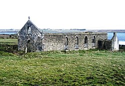 Ruined church near Pullathomas | |
| 54°14′57″N 9°48′40″W / 54.2491°N 9.81098°W / 54.2491; -9.81098 | |
| Country | Ireland |
| Province | Connacht |
| County | County Mayo |
| Area | |
| • Total | (Townland) 2.7745 km2 (685.59 acres) |
| Elevation | 49 m (161 ft) |
| Population (2011)[1] | 100 |
| Poll an tSómais is the only official name. The anglicised spelling Pollatomish and English name Pullathomas have no official status. | |
Pullathomas (Irish: Poll an tSómais;[2] also known as Kilcommon, Pollatomais, Pollatomish and Pollathomas, meaning "hollow of comfort")[3] is a Gaeltacht village and townland in northwest County Mayo, Ireland. In the barony of Erris and parish of Kilcommon, it lies close to the mouth of Broadhaven Bay next to Sruwaddacon Bay. Pullathomas townland has an area of approximately 685.6 acres (2.8 km2) and,[4] as of 2011, had a population of 100 people.[1]
History
Early history
The townland is also called Kilcommon named for Saint Coman. The area is recorded in the Annals of the Four Masters. [3]
In 1585, the Protestant Bishop of Killala is recorded to have owned the townland. In 1636, Michael Cormuck of Inver Castle leased Pullathomas from the Protestant Bishop. By 1770, the O'Donel family had taken over the lease of Pullathomas.[3]
A community of Augustinian friars once resided here but were later expelled. In the 1770s, the O'Donels built Kilcommon Lodge, which became a residence for Catholic clergy.[3]
19th century
The Society of Friends provided aid to people in Pullathomas during the famines of the early 19th century.[3]
In 1847 Kilcommon Lodge was attacked by people seeking food. [3]
Protestant proselytisation was attempted with chapels constructed. Pullathomas was connected by a road to Inver in 1842.[3]
Later history
A Protestant schoolhouse, Ivy Cottage, used as a military camp for anti-treaty forces during the Irish Civil War was later burnt by pro-treaty forces.[3]
The area around Dooncarton Mountain experienced intense rainfall causing a series of 30 peat landslides between Pullathomas and Glengad on 19 September 2003, causing damages amounting to €620,000.[5] A corner of the old graveyard was struck, sweeping graves into the sea.[6] Several million euros were spent in repairs.[7]
Geography

Pollatomish Bog NHA
Pollatomish Bog is a designated Natural Heritage Area of protected low lying blanket bog about 7 km south of the village. Grasses and sedges dominate the lower northern slopes with species like Cottongrasses recorded.[8]
See also
References
- ^ a b "CD164 - Mayo Population by Private Households, Occupied and Vacancy Rate". data.gov.ie. Central Statistics Office. Retrieved 31 December 2023.
Population [..] Townlands [..] Kilcommon or Pollatomish, Knocknalower, Co. Mayo [..] 100
- ^ "Poll an tSómais/Pollatomish". logainm.ie (in Irish). Retrieved 2023-12-30.
- ^ a b c d e f g h Noone, Fr. Sean (1991). Where The Sun Sets (1st ed.). Ballina: Erris Publications. pp. 221–232. ISBN 0951817906.
- ^ "Pollatomish Townland, Co. Mayo". www.townlands.ie. Retrieved 2023-12-30.
- ^ "Mayo landslides caused by freak weather event". The Irish Times. Retrieved 2023-12-30.
- ^ "Bishop: 'The pain is felt worldwide' as landslides destroy graveyard". Independent.ie. 2003-09-27. Retrieved 2023-12-30.
- ^ Long, Michael; Jennings, Paul (2006-03-01). "Analysis of the peat slide at Pollatomish, County Mayo, Ireland". Landslides. 3 (1): 51–61. doi:10.1007/s10346-005-0006-z. hdl:10197/3098. ISSN 1612-5118.
- ^ "Pollatomish Bog NHA | National Parks & Wildlife Service". www.npws.ie. Retrieved 2023-12-30.
Wikimedia Commons has media related to Pollatomish.
- v
- t
- e
Places in County Mayo

and townlands
- Achill Sound
- Askill
- Aghamore
- Ardogommon
- Attymass
- Aughagower
- Aughleam
- Balla
- Ballindine
- Ballintubber
- Ballinvoy
- Ballycastle
- Ballycroy
- Ballydavock
- Ballyglass
- Ballymacrah
- Barroosky
- Bekan
- Belcarra
- Belderrig
- Bellacorick
- Bellavary
- Binghamstown
- Bohalis
- Bohola
- Bonniconlon
- Breaffy
- Brackwanshagh
- Brickens
- Bunacurry
- Carracastle
- Carrowteige
- Carnacon
- Cashel
- Castlehill
- Claddy
- Cloghans
- Cogaula
- Cong
- Corraveggaun West
- Corrimbla
- Corroy
- Cregganbaun
- Cross
- Curraunboy
- Delphi
- Derrew
- Derrycorrib
- Dooagh
- Dooega
- Doohoma
- Dooniver
- Drummin
- Dugort
- Errew
- Fallmore
- Finny
- Glenamoy
- Glencastle
- Glengad
- Glenhest
- Glinsk
- Gweesalia
- Hollymount
- Inver
- Irishtown
- Islandeady
- Keel
- Kilcummin
- Kilfaul
- Kilgalligan
- Kilkelly
- Killala
- Killawalla
- Kilmaine
- Kilmeena
- Kilmovee
- Knock
- Knocknabola
- Knockanillaun
- Knockmore
- Knockroosky
- Lahardane
- Lecanvey
- Lisduvoge
- Lissaniska East
- Lissaniska West
- Mayo
- Meelick
- Midfield
- Moygownagh
- Mulranny
- Murrisk
- Neale
- Partry
- Pollagh
- Pontoon
- Portacloy
- Porturlin
- Pullathomas
- Rathnamagh
- Rossport
- Salia
- Shammer
- Shanaghy
- Sheean
- Shrule
- Sraheens
- Strade
- Tonragee
- Toormakeady
- Tulrahan
- Turlough
- List of townlands of County Mayo
- Category:Geography of County Mayo


