Puerto Rico Highway 803
Highway in Puerto Rico
Major junctions

 PR-152 / PR-802 in Cedro Arriba
 PR-805 in Palos Blancos
 PR-808 in Palos Blancos
 PR-164 in Palmarejo
←  PR-802 PR-802 | →  PR-805 PR-805 |
Puerto Rico Highway 803 (PR-803) is a north–south road that travels from eastern Corozal to southwestern Naranjito in Puerto Rico. With a length of 10.2 km (6.3 mi), it begins at PR-164 in Palmarejo barrio and ends at its junction with PR-152 and PR-802 in Cedro Arriba barrio.[2]
Route description
Puerto Rico Highway 803 is a rural road with one lane in each direction along its entire length. In Corozal, it begins at PR-164 intersection, crossing Palmarejo and Palos Blancos barrios until the Naranjito municipal limit. In Palos Blancos, PR-803 climbs the Corozal mountains and meets with PR-808 and PR-805 near the Monte Choca State Forest.[3] In Naranjito, it has a shorter length than in Corozal, located entirely within Cedro Arriba barrio, beginning from the Corozal municipal limit to its southern terminus at PR-152 and PR-802 intersection.[4]
- Puerto Rico Highway 803 by municipality
-
 Northern terminus at PR-164 junction in Palmarejo, Corozal, heading south
 -
 Southbound sign in Palmarejo, Corozal
 -
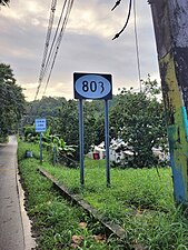
 Northbound sign in Cedro Arriba, Naranjito


History
Prior to its numerical designation, PR-803 was only known as Carretera de Palos Blancos. The current numerical designation corresponds to the 1953 Puerto Rico highway renumbering, a process implemented by the Puerto Rico Department of Transportation and Public Works (Spanish: Departamento de Transportación y Obras Públicas) that increased the insular highway network to connect existing routes with different locations around Puerto Rico.[5]
Major intersections
-
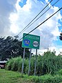
 PR-164 west near PR-803 intersection in Palmarejo, Corozal
 -
 PR-803 north at PR-808 intersection in Palos Blancos, Corozal
 -
 PR-803 south near PR-805 intersection in Palos Blancos, Corozal
 -
 PR-803 south near PR-152 and PR-802 junction in Cedro Arriba, Naranjito


| Municipality | Location | km[1] | mi | Destinations | Notes |
|---|---|---|---|---|---|
| Naranjito | Cedro Arriba | 10.2 | 6.3 | PR-152 / PR-802 – Naranjito, Barranquitas, Comerío, Maná | Southern terminus of PR-803 |
| Corozal | Palos Blancos | 8.0 | 5.0 |  PR-805 – Negros PR-805 – Negros | |
| 6.2 | 3.9 |  PR-808 – Cedro Abajo PR-808 – Cedro Abajo | |||
| Palmarejo | 0.0 | 0.0 | PR-164 – Corozal, Naranjito | Northern terminus of PR-803 | |
| 1.000 mi = 1.609 km; 1.000 km = 0.621 mi | |||||
See also
 Puerto Rico portal
 U.S. Roads portal

References
- ^ a b Google (29 February 2020). "PR-803" (Map). Google Maps. Google. Retrieved 29 February 2020.
- ^ National Geographic Maps (2011). Puerto Rico (Map). 1:125,000. Adventure Map (Book 3107). Evergreen, Colorado: National Geographic Maps. ISBN 978-1566955188. OCLC 756511572.
- ^ "PR-803, Corozal, Puerto Rico". pr.geoview.info. Retrieved 12 August 2019.
- ^ "PR-803, Naranjito, Puerto Rico". pr.geoview.info. Retrieved 12 August 2019.
- ^ "Corozal, Memoria Núm. 61" (PDF). Puerto Rico Planning Board (in Spanish). 1955. Retrieved 22 August 2023.
External links
 Media related to Puerto Rico Highway 803 at Wikimedia Commons
- v
- t
- e
 | This Puerto Rico road-related article is a stub. You can help Wikipedia by expanding it. |
- v
- t
- e


