Paseo Cornisa
Park in Spain
You can help expand this article with text translated from the corresponding article in Spanish. (February 2013) Click [show] for important translation instructions.
- View a machine-translated version of the Spanish article.
- Machine translation, like DeepL or Google Translate, is a useful starting point for translations, but translators must revise errors as necessary and confirm that the translation is accurate, rather than simply copy-pasting machine-translated text into the English Wikipedia.
- Do not translate text that appears unreliable or low-quality. If possible, verify the text with references provided in the foreign-language article.
- You must provide copyright attribution in the edit summary accompanying your translation by providing an interlanguage link to the source of your translation. A model attribution edit summary is
Content in this edit is translated from the existing Spanish Wikipedia article at [[:es:Paseo Cornisa de Algeciras]]; see its history for attribution. - You may also add the template
{{Translated|es|Paseo Cornisa de Algeciras}}to the talk page. - For more guidance, see Wikipedia:Translation.
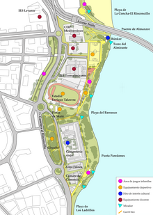
Paseo Cornisa is a park in Algeciras, Spain. It was inaugurated in May 2007. It stretches for just over a kilometre between Punta del Cementerio and Punta del Almirante in the north of the city near the old cemetery and parallel to the Playa del Barranco and Playa de El Rinconcillo. The park has an area of over 20,000 square metres (220,000 sq ft).[1] Within the park is the Torre del Almirante or Admiral's Tower which dates from the 14th century.
In the eighteenth century La Almiranta Battery was near the tower and its role was to defend the city of Algeciras. It worked with the other coastal batteries to defend the area during the Battle of Algeciras in 1801. This battery was partially destroyed by a magazine explosion in the nineteenth century which also damaged the tower.
During the Spanish Civil War the battery was used as a place for machine guns. Nearby was an area that was used by firing squads.
References
- ^ "Urbanización del Paseo de la Cornisa en Algeciras" (in Spanish). DETEA. Archived from the original on 14 July 2013. Retrieved 6 February 2013.
- v
- t
- e
Algeciras
- History of Algeciras
- Algeciras Campaign
- Algeciras Conference
- Battle of Río Palmones
- Caetaria
- Roman fish salting factory
- Fuerte de San Diego
- Fuerte de San García
- Roman kilns of El Rinconcillo
- Siege of Algeciras (1278–1279)
- Battle of Algeciras (1278)
- Siege of Algeciras (1309)
- Siege of Algeciras (1342–1344)
- Siege of Algeciras (1369)
- Battle of Algeciras (1801)
- Taifa of Algeciras

- Bay of Gibraltar
- Cala Arenas
- Parque del Centenario
- Parque de las Acacias de Algeciras
- Parque de la Conferencia
- Parque María Cristina
- Paseo Cornisa
- El Pelayo
- Playa del Barranco
- Playa de El Chinarral
- Playa de Getares
- Playa de Los Ladrillos
- Playa de El Rinconcillo
- Río de la Miel
- Río Pícaro
- Río Palmones
- Algeciras Heliport
- Algeciras Municipal Library
- Algeciras Town Hall
- Aqueduct of Algeciras
- Bahia Park
- Capilla de la Caridad
- Capilla del Cristo de la Alameda
- Chapel of Our Lady of Europe
- Ermita Sagrado Corazón de Jesús
- Fuerte de Isla Verde
- Hospital de la Caridad
- Hospital Punta de Europa
- Iglesia de Nuestra Señora de la Palma
- Kursaal of Algeciras
- La Villa Vieja
- Lighthouse of Isla Verde
- Lighthouse of Punta Carnero
- Marinid Walls of Algeciras
- Municipal Museum of Algeciras
- Teatro Florida
- Torre de los Adalides
- Tower of Almirante
- Torre del Arroyo del Lobo
- Torre del Fraile
- Economy of Algeciras
- Hotel AC Algeciras
- Hotel Anglo-Hispano
- Hotel Reina Cristina
- Hotel Sevilla
- Mercado de abastos de Algeciras
- Mezquita Aljama de Algeciras
- Patio del Coral
- Plaza Alta
- Plaza de Andalucía
- Plaza de toros de Las Palomas
- Polígono Industrial Cortijo Real
- Port of Algeciras
- Escuela de Artes y Oficios de Algeciras
- Fiestas of Algeciras
- Orquesta Sinfónica de Algeciras
- Royal Fair of Algeciras
- Algeciras CF
- Algeciras Balonmano
- Balonmano Ciudad de Algeciras
- Club Baloncesto Ciudad de Algeciras
- Estadio Nuevo Mirador
 Category

 | This article about a location in Andalusia, Spain, is a stub. You can help Wikipedia by expanding it. |
- v
- t
- e
36°08′43″N 5°26′47″W / 36.14528°N 5.44639°W / 36.14528; -5.44639


