National Register of Historic Places listings in Knox County, Nebraska

This is a list of the National Register of Historic Places listings in Knox County, Nebraska.
This is intended to be a complete list of the properties and districts on the National Register of Historic Places in Knox County, Nebraska, United States. The locations of National Register properties and districts for which the latitude and longitude coordinates are included below, may be seen in a map.[1]
There are 15 properties and districts listed on the National Register in the county, and one former listing.
This National Park Service list is complete through NPS recent listings posted September 5, 2024.[2]
Map all coordinates using OpenStreetMap
Download coordinates as:
- KML
- GPX (all coordinates)
- GPX (primary coordinates)
- GPX (secondary coordinates)
Current listings
| [3] | Name on the Register | Image | Date listed[4] | Location | City or town | Description |
|---|---|---|---|---|---|---|
| 1 | Argo Hotel |  | May 5, 1999 (#99000478) | 211 Kansas St. 42°43′54″N 97°29′49″W / 42.731667°N 97.496944°W / 42.731667; -97.496944 (Argo Hotel) | Crofton | |
| 2 | The Commercial Hotel |  | April 5, 1990 (#90000563) | 117 Main St. 42°36′00″N 98°02′00″W / 42.6°N 98.033333°W / 42.6; -98.033333 (The Commercial Hotel) | Verdigre | |
| 3 | Congregational Church and Manse | 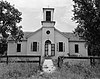 | March 16, 1972 (#72000753) | Santee Sioux Reservation 42°50′19″N 97°50′46″W / 42.838611°N 97.846111°W / 42.838611; -97.846111 (Congregational Church and Manse) | Santee | |
| 4 | Episcopal Church |  | March 16, 1972 (#72000754) | On the Missouri River in the Santee Sioux Reservation 42°50′27″N 97°50′15″W / 42.84085°N 97.83763°W / 42.84085; -97.83763 (Episcopal Church) | Santee | |
| 5 | Gross State Aid Bridge | 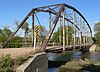 | June 29, 1992 (#92000773) | County road 885 Rd over Verdigris Creek, 3.5 miles north and 0.2 miles west of Verdigre 42°39′16″N 98°02′34″W / 42.654444°N 98.042778°W / 42.654444; -98.042778 (Gross State Aid Bridge) | Verdigre | |
| 6 | Knox County Courthouse |  | July 5, 1990 (#90000972) | Main St. between Brazile and Bridge Sts. 42°36′32″N 97°52′37″W / 42.608889°N 97.876944°W / 42.608889; -97.876944 (Knox County Courthouse) | Center | |
| 7 | Niobrara River Bridge |  | November 12, 1992 (#92001576) | Over the Niobrara River 1.3 miles northwest of Niobrara 42°46′00″N 98°02′55″W / 42.766667°N 98.048611°W / 42.766667; -98.048611 (Niobrara River Bridge) | Niobrara | |
| 8 | Ponca Agency Archeological District | Upload image | July 12, 2006 (#06000555) | Address Restricted | Niobrara | |
| 9 | Ponca Fort Site | Upload image | April 3, 1973 (#73001066) | Hilltop in Section 29, Township 33 North, Range 7 West[5] 42°48′29″N 98°09′50″W / 42.808056°N 98.163833°W / 42.808056; -98.163833 (Ponca Fort Site) | Verdel | University of Nebraska excavations in the 1930s showed this site to be Arikara-affiliated and to date from circa 1790 to 1802[6] |
| 10 | Ponca Tribal Self-Help Community Building Historic District |  | March 13, 2003 (#03000106) | 88915 521 Avenue;[7] approximately 3 miles southeast of Niobrara 42°42′50″N 98°04′30″W / 42.71381°N 98.07495°W / 42.71381; -98.07495 (Ponca Tribal Self-Help Community Building Historic District) | Niobrara | |
| 11 | Rad Sladkovsky | 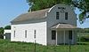 | June 29, 1982 (#82003193) | At Pishelville, northwest of Verdigre 42°43′34″N 98°12′41″W / 42.72619°N 98.21152°W / 42.72619; -98.21152 (Rad Sladkovsky) | Verdigre | |
| 12 | St. Rose of Lima Catholic Church and School Complex |  | March 21, 2011 (#11000106) | 1302-1316 W. 5th St.[8] 42°43′45″N 97°30′03″W / 42.72922°N 97.50085°W / 42.72922; -97.50085 (St. Rose of Lima Catholic Church and School Complex) | Crofton | |
| 13 | Winnetoon Jail |  | February 27, 1995 (#95000094) | Junction of 1st St. and Sherman Ave. 42°30′52″N 97°57′43″W / 42.514444°N 97.961944°W / 42.514444; -97.961944 (Winnetoon Jail) | Winnetoon | |
| 14 | Winnetoon Public School | Upload image | March 13, 2020 (#100005053) | 308 Jones St. 42°30′54″N 97°57′49″W / 42.5150°N 97.9637°W / 42.5150; -97.9637 (Winnetoon Public School) | Winnetoon | |
| 15 | Z.C.B.J. Opera House | 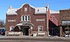 | July 6, 1988 (#88000946) | 4th Ave. and Main 42°35′48″N 98°02′00″W / 42.596778°N 98.033333°W / 42.596778; -98.033333 (Z.C.B.J. Opera House) | Verdigre |
Former listings
| [3] | Name on the Register | Image | Date listed | Date removed | Location | City or town | Description |
|---|---|---|---|---|---|---|---|
| 1 | Pospeshil Theatre | 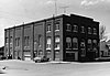 | September 28, 1988 (#88000935) | March 25, 2019 | 123 Broadway 42°35′53″N 97°38′44″W / 42.598056°N 97.645556°W / 42.598056; -97.645556 (Pospeshil Theatre) | Bloomfield | Burned down; Bloomfield library was built in 2000 on former site[9] |
See also
Wikimedia Commons has media related to National Register of Historic Places in Knox County, Nebraska.
- List of National Historic Landmarks in Nebraska
- National Register of Historic Places listings in Nebraska
References
- ^ The latitude and longitude information provided in this table was derived originally from the National Register Information System, which has been found to be fairly accurate for about 99% of listings. Some locations in this table may have been corrected to current GPS standards.
- ^ National Park Service, United States Department of the Interior, "National Register of Historic Places: Weekly List Actions", retrieved September 5, 2024.
- ^ a b Numbers represent an alphabetical ordering by significant words. Various colorings, defined here, differentiate National Historic Landmarks and historic districts from other NRHP buildings, structures, sites or objects.
- ^ The eight-digit number below each date is the number assigned to each location in the National Register Information System database, which can be viewed by clicking the number.
- ^ Howard, James H. "Known Village Sites of the Ponca". Plains Anthropologist 15.48 (1970): 109-134: 125.
- ^ Wood, W. Raymond. "Historical and Archeological Evidence for Arikara Visits to the Central Plains". Plains Anthropologist 4 (1955): 27-39: 34.
- ^ "Culture Department". Ponca Tribe of Nebraska. Retrieved 2013-05-28.
- ^ The National Park Service announcement has the address as South 5th St. Per the church website, the actual address is West 5th St.
- ^ Koertje, Norma."Bloomfield Public Library". Nebraska Library Quarterly. 2000-06-25. Archived 2008-11-21 from original. Retrieved 2010-02-19.
- v
- t
- e

- Adams
- Antelope
- Arthur
- Banner
- Blaine
- Boone
- Box Butte
- Boyd
- Brown
- Buffalo
- Burt
- Butler
- Cass
- Cedar
- Chase
- Cherry
- Cheyenne
- Clay
- Colfax
- Cuming
- Custer
- Dakota
- Dawes
- Dawson
- Deuel
- Dixon
- Dodge
- Douglas
- Dundy
- Fillmore
- Franklin
- Frontier
- Furnas
- Gage
- Garden
- Garfield
- Gosper
- Grant
- Greeley
- Hall
- Hamilton
- Harlan
- Hayes
- Hitchcock
- Holt
- Hooker
- Howard
- Jefferson
- Johnson
- Kearney
- Keith
- Keya Paha
- Kimball
- Knox
- Lancaster
- Lincoln
- Logan
- Loup
- Madison
- McPherson
- Merrick
- Morrill
- Nance
- Nemaha
- Nuckolls
- Otoe
- Pawnee
- Perkins
- Phelps
- Pierce
- Platte
- Polk
- Red Willow
- Richardson
- Rock
- Saline
- Sarpy
- Saunders
- Scotts Bluff
- Seward
- Sheridan
- Sherman
- Sioux
- Stanton
- Thayer
- Thomas
- Thurston
- Valley
- Washington
- Wayne
- Webster
- Wheeler
- York
- Bridges
- Historic districts
- Houses
- National Historic Landmarks
- Properties of religious function
- Railway stations
 Category
 List
List National Register of Historic Places Portal


Municipalities and communities of Knox County, Nebraska, United States | ||
|---|---|---|
County seat: Center | ||
| Cities |  | |
| Villages | ||
| Townships | ||
| CDP | ||
| Unincorporated communities | ||
| Indian reservations | ||
| ||


