Mount Sanford (Alaska)
Shield volcano in the state of Alaska


Mount Sanford
Alaska
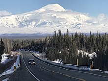

Mount Sanford is a shield volcano[3] in the Wrangell Volcanic Field, in eastern Alaska near the Copper River. It is the sixth highest mountain in the United States and the third highest volcano behind Mount Bona and Mount Blackburn. The south face of the volcano, at the head of the Sanford Glacier, rises 8,000 feet (2,400 m) in 1 mile (1,600 m) resulting in one of the steepest gradients in North America.
Geology
Mount Sanford is mainly composed of andesite, and is an ancient peak, being mostly Pleistocene, although some of the upper parts of the mountain may be Holocene. The mountain first began developing 900,000 years ago, when it began growing on top of three smaller shield volcanoes that had coalesced. Although obscured by icefields, the uppermost 2,000 feet (610 m) of the mountain appear to be a lava dome filling a larger summit crater.[5]
Two notable events in the mountain's history include a large rhyolite flow which traveled some 11 miles (18 km) to the north east of the peak and has a volume of about 5 cubic miles (21 km3), and another flow which erupted from a rift zone on the flank of the volcano some 320,000 years ago. The second flow was basaltic in nature and marks the most recent activity of the volcano. The flow was dated using radiometric methods.[3]
Observers have reported minor activity at Sanford, primarily vapor clouds or plumes from ice and rockfalls. Some reported incidents may have been orographic clouds, while others have been interpreted as avalanches.[6]
The majority of Mount Sanford above 8,000 feet (2,400 m) is covered by icefields, merging to the south with that surrounding Mount Wrangell. The largest glacier on Sanford is the Sanford Glacier, whose source lies at the steep cirque that cuts into the south side of the mountain.[5]
History
The mountain was named in 1885 by Lieutenant Henry T. Allen of the U.S. Army, a descendant of Reuben Sanford (an American politician).[2]
Mount Sanford was first climbed on July 21, 1938 by noted mountaineers Terris Moore and Bradford Washburn, via the still-standard North Ramp route up the Sheep Glacier. This route "offers little technical difficulty" and "is a glacier hike all the way to the summit"[4] but is still a serious mountaineering challenge (Alaska Grade 2) due to the altitude and latitude of the peak. The base of the route is usually accessed by air, but landing near the mountain is not straightforward.
On March 12, 1948, Northwest Airlines Flight 4422 crashed into Mount Sanford. All 24 passengers and 6 crew members were killed. The wreckage was quickly covered by snow and was not found again until 1999.[7]
The first solo ascent of Mount Sanford was achieved on September 19, 1968, by Japanese mountaineer Naomi Uemura, who later died just after making the first solo winter ascent of Denali.[8]
See also
 North America portal
 United States portal
 Alaska portal
 Mountains portal
 Volcanoes portal


- List of mountain peaks of North America
- List of the highest major summits of the United States
- List of the most prominent summits of the United States
- List of the most isolated major summits of the United States
- List of volcanoes in the United States
References
- ^ a b c "Mount Sanford, Alaska". Peakbagger.com. Retrieved 2015-12-30.
- ^ a b "Mount Sanford". Geographic Names Information System. United States Geological Survey, United States Department of the Interior. Retrieved 2008-12-23.
- ^ a b c "Sanford". Global Volcanism Program. Smithsonian Institution. Retrieved 2021-01-04.
- ^ a b c Wood, Michael; Coombs, Colby (2001). Alaska: A climbing guide. The Mountaineers. pp. 146–148. ISBN 0-89886-724-X.
- ^ a b Richter, Donald H.; Rosenkrans, Danny S.; Steigerwald, Margaret J. "Guide to the Volcanoes of the Western Wrangll Mountains, Alaska, U.S. Geological Survey Bulletin 2072" (PDF). U.S. Geological Survey.
- ^ "Sanford reported activity". Alaska Volcano Observatory. U.S. Geological Survey. Retrieved 17 February 2019.
- ^ "Accident description". Aviation Safety Network. Retrieved 2008-12-23.
- ^ Vickery, Jim Dale (1998). Winter Sign. Minneapolis: University of Minnesota Press. pp. 50–51. ISBN 0-8166-2969-2.
Sources
- Richter, Donald H.; Rosenkrans, Danny S.; Steigerwald, Margaret J. (1995). Guide to the Volcanoes of the Western Wrangell Mountains, Alaska (PDF). USGS Bulletin 2072.
- Richter, Donald H.; Preller, Cindi C.; Labay, Keith A.; Shew, Nora B. (2006). Geologic Map of the Wrangell-Saint Elias National Park and Preserve, Alaska. USGS Scientific Investigations Map 2877.
- Winkler, Gary R. (2000). A Geologic Guide to Wrangell—Saint Elias National Park and Preserve, Alaska: A Tectonic Collage of Northbound Terranes. USGS Professional Paper 1616. ISBN 0-607-92676-7.
- Wood, Charles A.; Kienle, Jürgen, eds. (1990). Volcanoes of North America. Cambridge University Press. ISBN 0-521-43811-X.
External links
- Mount Sanford at the Alaska Volcano Observatory
- "Sanford Trip Report". Mt. Sanford Expedition via the Sheep Glacier, 2014. Retrieved 2014-08-14.
- v
- t
- e
- Denali
- Mount Logan
- Pico de Orizaba
- Mount Saint Elias
- Volcán Popocatépetl
- Mount Foraker
- Mount Lucania
- Volcán Iztaccíhuatl
- King Peak
- Mount Bona
- Mount Steele
- Mount Blackburn
- Mount Sanford
- Mount Wood
- Mount Vancouver
- Mount Slaggard
- Nevado de Toluca
- Mount Fairweather
- Sierra Negra
- Mount Hubbard
- Mount Bear
- Mount Walsh
- Mount Hunter
- Volcán La Malinche
- Mount Whitney
- Mount Alverstone
- University Peak
- Mount Elbert
- Mount Massive
- Mount Harvard
- Mount Rainier
- Mount Williamson
- McArthur Peak
- Blanca Peak
- La Plata Peak
- Uncompahgre Peak
- Crestone Peak
- Mount Lincoln
- Castle Peak
- Grays Peak
- Mount Antero
- Mount Blue Sky
- Longs Peak
- Mount Wilson
- White Mountain Peak
- North Palisade
- Mount Princeton
- Mount Yale
- Mount Shasta
- Maroon Peak
- Mount Wrangell
- Mount Sneffels
- Capitol Peak
- Pikes Peak
- Windom Peak/Mount Eolus
- Mount Augusta
- Handies Peak
- Culebra Peak
- Cofre de Perote
- San Luis Peak
- Mount of the Holy Cross
- Nevado de Colima
- Grizzly Peak
- Mount Humphreys
- Mount Keith
- Mount Strickland
- Mount Ouray
- Vermilion Peak
- Avalanche Peak
- Atna Peaks
- Volcán Tajumulco
- Regal Mountain
- Mount Darwin
- Mount Hayes
- Mount Silverheels
- Rio Grande Pyramid
- Gannett Peak
- Mount Kaweah
- Grand Teton
- Mount Cook
- Mount Morgan
- Mount Gabb
- Bald Mountain
- Mount Oso
- Mount Jackson
- Mount Tom
- Bard Peak
- Cerro Tláloc
- West Spanish Peak
- Mount Powell
- Hagues Peak
- Mount Dubois
- Tower Mountain
- Treasure Mountain
- Kings Peak
- North Arapaho Peak
- Mount Pinchot
- Mount Natazhat
- Mount Jarvis
- Parry Peak
- Bill Williams Peak
- Sultan Mountain
- Mount Herard
- Volcán Tacaná
- West Buffalo Peak
- Mount Craig
- Tressider Peak
- Summit Peak
- Middle Peak/Dolores Peak
- Antora Peak
- Henry Mountain
- Hesperus Mountain
- Mount Silverthrone
- Jacque Peak
- Bennett Peak
- Wind River Peak
- Mount Waddington
- Conejos Peak
- Mount Marcus Baker
- Cloud Peak
- Wheeler Peak
- Francs Peak
- Twilight Peak
- South River Peak
- Mount Ritter
- Red Slate Mountain


