Minalungao National Park
National park in the Philippines
15°17′55.3″N 121°07′19.6″E / 15.298694°N 121.122111°E / 15.298694; 121.122111Minalungao National Park is a protected area of the Philippines located in the municipality of General Tinio, Nueva Ecija, near its Boundary with Doña Remedios Trinidad, Bulacan. The park covers an area of 2,018 hectares[1] centered along the scenic Peñaranda River bordered on both sides by up to 16-meter high limestone walls in the foothills of the Sierra Madre mountain range. It was established in 1967 by virtue of Republic Act No. 5100.[2]
The park is considered one of the few remaining natural environments in this region north of Manila. It is promoted by the local government as an ecotourism destination offering breath-taking scenery of green pristine river and unique rock formations. A system of unexplored caverns have also been identified as potential attractions. Facilities for picnics, swimming, fishing, raft riding and cliff diving have likewise been put up to draw more visitors.[3][4]
See also
References
- ^ "Region 3 - Protected Areas". Department of Environment of Natural Resources Protected Areas and Wildlife Bureau. Archived from the original on 21 March 2012. Retrieved 15 June 2012.
- ^ "R.A. No. 5100". PhilippineLaw.info. Archived from the original on 31 May 2012. Retrieved 15 June 2012.
- ^ "The Minalungao National Park". Municipal Government of General Tinio. Retrieved 15 June 2012.
- ^ "Towns and Cities - Gen. Tinio". Biyahero.net. Retrieved 15 June 2012.
External links
 Media related to Minalungao National Park at Wikimedia Commons

- v
- t
- e
- Aurora Memorial
- Balbalasang-Balbalan
- Bangan Hill
- Bataan
- Biak-na-Bato
- Caramoan
- Cassamata Hill
- Fuyot Springs
- Hundred Islands
- Libmanan Caves
- Luneta (Rizal)
- Minalungao
- Mount Arayat
- Mount Data
- Mount Pulag
- Mounts Iglit–Baco
- Naujan Lake
- Northern Luzon Heroes Hill
- Olongapo Naval Base Perimeter
- Pagsanjan Gorge
- Paoay Lake
- Puerto Princesa Subterranean River
- Quezon Memorial
Tourism in Central Luzon | ||
|---|---|---|
| Beaches and islands | 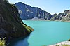 | |
| Cultural | ||
| Historical | ||
| Parks and recreation | ||
| Religious |
| |
| Venues |
| |
 | This article about a location in Central Luzon region is a stub. You can help Wikipedia by expanding it. |
- v
- t
- e


