Long Knoll
Mountain in Wiltshire, England
| Long Knoll | |
|---|---|
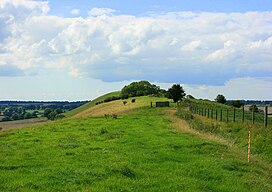 Long view of Long Knoll | |
| Highest point | |
| Elevation | 288 |
| Prominence | 171 m (561 ft) |
| Parent peak | Beacon Batch |
| Listing | Marilyn |
| Geography | |
| Location | Wiltshire, England |
| OS grid | ST786376 |
| Topo map | OS Landranger 183 |
Long Knoll (grid reference ST794376) is a hill in the west of the English county of Wiltshire. It is a ridge of chalk grassland, some 1.5 kilometres (1 mi) in length, and forms the boundary between the civil parishes of Kilmington to the south and Maiden Bradley to the north. The ridge is 288 metres (945 ft) above sea level at its highest point and it is possible to view King Alfred's Tower, Cranmore Tower, the Black Mountains and Glastonbury Tor on clear days.[1]
The hill is the site of the 34.2-hectare (85-acre) Long Knoll biological Site of Special Scientific Interest, which was notified in 1971, and is part of the Cranborne Chase and West Wiltshire Downs Area of Outstanding Natural Beauty. Long Knoll is the most westerly part of the remains of a chalk plateau. It forms a ridge that runs east and west for about a mile, and is 60 m (200 ft) higher than the surrounding land. The south-facing slope has a mosaic of longer and shorter turfs and has a mixture of grasses, sedges and forbs. Here grow a typical calcareous community including glaucus sedge, sheep's-fescue, meadow oat-grass, heath-grass and common quaking-grass, together with cowslip, salad burnet, rock-rose, betony, small scabious and devil's-bit scabious. Some of the less common chalk grassland herbs include clustered bellflower, early purple orchid, horseshoe vetch, kidney vetch and chalk milkwort.[2]
The north-facing slope, by contrast, has more mosses and bryophytes on the closely grazed turf, with tufted hair-grass, false oat-grass, red fescue and crested hair-grass. Common valerian is an unusual species to find on chalk soils, and other herbs include autumn gentian, fairy flax and an abundance of devil's-bit scabious.[2]
Long Knoll is categorised as a Marilyn, a hill with topographic prominence of at least 150 metres (492 ft).[3]
References
- ^ Timlett, Paul (7 April 2019). "Long Knoll and Little Knoll, Kilmington". Retrieved 25 March 2020.
- ^ a b "Long Knoll" (PDF). Natural England. Retrieved 24 March 2020.
- ^ Alan Dawson. "Marilyns". The Relative Hills of Britain.
A Marilyn is a hill of any height with a drop of 150 metres or more on all sides. In other words, a relatively high hill. The Marilyns in Britain and the Isle of Man are listed in a book called The Relative Hills of Britain (RHB) by Alan Dawson, published by Cicerone Press in April 1992. Details of subsequent changes have been published in a series of updates.
Wikimedia Commons has media related to Long Knoll.
- v
- t
- e
- Acres Farm Meadow
- River Avon System
- Baverstock Juniper Bank
- Bencroft Hill Meadows
- Bentley Wood
- Bincknoll Dip Woods
- Blackmoor Copse
- Botley Down
- Bowerchalke Downs
- Box Mine
- Bracknell Croft
- Bradley Woods
- Bratton Downs
- Brickworth Down and Dean Hill
- Brimsdown Hill
- Britford Water Meadows
- Burcombe Down
- Burderop Wood
- Calstone and Cherhill Downs
- Camp Down
- Chilmark Quarries
- Chickengrove Bottom
- Chilton Foliat Meadows
- Clattinger Farm
- Clearbury Down
- Cley Hill
- Cloatley Manor Farm Meadows
- Clout's Wood
- Coate Water
- Cockey Down
- Colerne Park and Monk's Wood
- The Coombes, Hinton Parva
- Cotswold Water Park
- Cranborne Chase
- Dank's Down and Truckle Hill
- Distillery Farm Meadows
- East Harnham Meadows
- Ebsbury Down
- Emmett Hill Meadows
- Figsbury Ring
- Fonthill Grottoes
- Fyfield Down
- Gallows Hill
- Goldborough Farm Meadows
- Great Cheverell Hill
- Great Yews
- Gutch Common
- Ham Hill
- Hang Wood
- Harries Ground, Rodbourne
- Haydon Meadow
- Heath Hill Farm
- Homington and Coombe Bissett Downs
- Honeybrook Farm
- Inwood, Warleigh
- Jones's Mill
- River Kennet
- Kennet and Lambourn Floodplain
- King's Play Hill
- Knapp and Barnett's Downs
- Knighton Downs and Wood
- Landford Bog
- Landford Heath
- Langley Wood and Homan's Copse
- Little Grubbins Meadow
- Long Knoll
- Loosehanger Copse and Meadows
- Lower Coombe and Ferne Brook Meadows
- Lower Woodford Water Meadows
- Midford Valley Woods
- Morgan's Hill
- The New Forest
- North Meadow, Cricklade
- Odstock Down
- Out Woods
- Parsonage Down
- Pewsey Downs
- Picket and Clanger Wood
- Piggledene
- Pike Corner
- Pincombe Down
- Porton Down
- Porton Meadows
- Prescombe Down
- Rack Hill
- Ravensroost Wood
- Restrop Farm and Brockhurst Wood
- Rotherley Downs
- Roundway Down and Covert
- Salisbury Plain
- Savernake Forest
- Scratchbury & Cotley Hills
- Silbury Hill
- Spye Park
- Starveall and Stony Down
- Steeple Langford Down
- Stockton Wood and Down
- Stoke Common Meadows
- Stratford Toney Down
- Sutton Lane Meadows
- Throope Down
- River Till
- Tytherington Down
- Upper Waterhay Meadow
- Upton Cow Down
- West Yatton Down
- Whiteparish Common
- Whitesheet Hill
- Win Green Down
- Winklebury Hill
- Winsley Mines
- Wylye and Church Dean Downs
- Yarnbury Castle
- Neighbouring areas
- Avon
- Berkshire
- Dorset
- Gloucestershire
- Hampshire
- Oxfordshire
- Somerset


