List of national monuments in County Cork
Map all coordinates using OpenStreetMap
Download coordinates as:
- KML
- GPX (all coordinates)
- GPX (primary coordinates)
- GPX (secondary coordinates)
The Irish state has officially approved the following list of national monuments in County Cork. In the Republic of Ireland, a structure or site may be deemed to be a "national monument", and therefore worthy of state protection, if it is of national importance. If the land adjoining the monument is essential to protect it, this land may also be protected.
National Monuments
| NM# | Monument name | Description | Image | Townland | Location |
|---|---|---|---|---|---|
| 645 | Altar Wedge Tomb | Wedge Tomb |  | Altar | 51°30′49″N 9°38′38″W / 51.51373°N 9.64398°W / 51.51373; -9.64398 |
| 314 | Ardskeagh Church | Church | Ardskeagh (Fermoy barony) | 52°19′55″N 8°37′41″W / 52.331832°N 8.627986°W / 52.331832; -8.627986 | |
| 301 | Ballybeg | Dovecote | 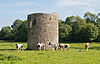 | Ballybeg East | 52°13′13″N 8°40′11″W / 52.22023°N 8.66984°W / 52.22023; -8.66984 |
| 301 | Ballybeg | Tower |  | Ballybeg West | 52°13′12″N 8°40′07″W / 52.21989°N 8.66851°W / 52.21989; -8.66851 |
| 301 | Ballybeg Abbey | Friary (Augustinian) |  | Buttevant | 52°13′10″N 8°40′11″W / 52.21941°N 8.66976°W / 52.21941; -8.66976 |
| 22 | Templekieran, Clear Island | Church & Cross inscribed pillar | Ballyieragh North | 51°26′27″N 9°30′22″W / 51.44070°N 9.50602°W / 51.44070; -9.50602 | |
| 425 | Ballinacarriga Castle | Castle |  | Dunmanway | 51°42′20″N 9°01′54″W / 51.70561°N 9.03175°W / 51.70561; -9.03175 |
| 641 | Barryscourt Castle | Castle |  | Carrigtwohill | 51°54′17″N 8°15′34″W / 51.90462°N 8.25937°W / 51.90462; -8.25937 |
| 594 | Blossomfort | Ringfort | Blossomfort | 52°09′41″N 8°45′15″W / 52.161504°N 8.754160°W / 52.161504; -8.754160 | |
| 558 | Glanworth | Medieval tower |  | Boherash | 52°11′21″N 8°21′20″W / 52.189069°N 8.355511°W / 52.189069; -8.355511 |
| 558 | Glanworth Castle | Castle |  | Glanworth | 52°11′17″N 8°21′17″W / 52.18817°N 8.3547°W / 52.18817; -8.3547 |
| 558 | Rock Abbey, Glanworth | Friary (Franciscan) |  | Boherash | 52°11′21″N 8°21′22″W / 52.18911°N 8.35625°W / 52.18911; -8.35625 |
| 450 | Breeny More Stone Circle | Stone Circle & boulder burials | Breeny More | 51°44′32″N 9°22′30″W / 51.742145°N 9.375097°W / 51.742145; -9.375097 | |
| 202 | Buttevant Abbey | Friary (Franciscan) |  | Buttevant | 52°13′52″N 8°40′09″W / 52.23124°N 8.66909°W / 52.23124; -8.66909 |
| 233 | Cahervagliar | Ringfort | Cappeen West | 51°47′35″N 8°59′49″W / 51.79310°N 8.99694°W / 51.79310; -8.99694 | |
| 660 | Carrigagulla | Stone Circle |  | Ballinagree | 52°00′01″N 8°54′59″W / 52.000410°N 8.916359°W / 52.000410; -8.916359 |
| 255 | Carrigaphooca Castle | Castle |  | Carrigaphooca | 51°54′31″N 9°01′42″W / 51.90855°N 9.02847°W / 51.90855; -9.02847 |
| 255 | Carrigaphooca stone circle | Stone Circle | Carrigaphooca | 51°54′35″N 9°01′30″W / 51.909610°N 9.024975°W / 51.909610; -9.024975 | |
| 656 | Castledonovan Castle | Castle |  | Castledonovan | 51°41′32″N 9°16′57″W / 51.69211°N 9.28259°W / 51.69211; -9.28259 |
| 281 | Mallow Castle | Castle |  | Castlelands | 52°08′02″N 8°38′22″W / 52.13389°N 8.63945°W / 52.13389; -8.63945 |
| 536 | Clodagh Standing Stones | Standing Stones - Pair | Clodagh, County Cork | 51°41′53″N 9°13′27″W / 51.69804°N 9.22428°W / 51.69804; -9.22428 | |
| 240 | Conna Castle | Castle |  | Conna | 52°05′40″N 8°06′06″W / 52.09454°N 8.10170°W / 52.09454; -8.10170 |
| 592 | Carn Tierna | Hillfort & Cairn | Coolcarron (Fermoy) | 52°06′54″N 8°16′58″W / 52.114982°N 8.282754°W / 52.114982; -8.282754 | |
| 565 | Coolcoulaghta Standing Stones | Standing Stones - Pair | Coolcoulaghta | 51°35′48″N 9°32′36″W / 51.59669°N 9.54334°W / 51.59669; -9.54334 | |
| 395 | Coole Upper Churches | Two Churches |  | Coole Upper | 52°06′31″N 8°12′12″W / 52.10873°N 8.20338°W / 52.10873; -8.20338 |
| 600 | Derryarkane Stone Circle | Stone Circle & Standing Stone | Derryarkane | 51°43′43″N 9°22′19″W / 51.72859°N 9.37206°W / 51.72859; -9.37206 | |
| 296 | Drishane Castle | Castle |  | Drishane More | 52°04′31″N 9°02′55″W / 52.07515°N 9.04849°W / 52.07515; -9.04849 |
| 339 | Dromaneen Castle | Castle |  | Dromaneen | 52°07′35″N 8°43′50″W / 52.12636°N 8.73066°W / 52.12636; -8.73066 |
| 381 | Drombeg | Circle, Hut Site & Fulacht Fiadh |  | Glandore | 51°33′52″N 9°05′13″W / 51.56455°N 9.08702°W / 51.56455; -9.08702 |
| 169 | Sherkin Abbey | Friary (Franciscan) |  | Sherkin Island | 51°28′34″N 9°24′01″W / 51.47613°N 9.40022°W / 51.47613; -9.40022 |
| 374 | Farranahineeny Stone Row | Stone Row | Farranahineeny | 51°47′42″N 9°08′20″W / 51.79494°N 9.13888°W / 51.79494; -9.13888 | |
| 284 | Knockdrum Stone Fort | Cashel |  | Farrandau | 51°31′36″N 9°11′37″W / 51.52653°N 9.19368°W / 51.52653; -9.19368 |
| 426 | Ballycrovane Ogham Stone | Ogham Stone |  | Faunkill and the Woods | 51°42′47″N 9°56′41″W / 51.71315°N 9.94460°W / 51.71315; -9.94460 |
| 535 | Charles Fort | Star-Shaped-Fort |  | Summer Cove | 51°41′47″N 8°29′56″W / 51.6965°N 8.499°W / 51.6965; -8.499 |
| 552 | Greenhill Ogham Stones | Ogham Stones | Greenhill | 52°04′40″N 8°36′25″W / 52.07782°N 8.60684°W / 52.07782; -8.60684 | |
| 502 | Island Wedge Tomb | Wedge Tomb | Island (Rahan) | 52°04′04″N 8°34′47″W / 52.067690°N 8.579607°W / 52.067690; -8.579607 | |
| 490 | Kilbolane Castle | Castle |  | Milford | 52°20′20″N 8°51′04″W / 52.339°N 8.851°W / 52.339; -8.851 |
| 182 | Kilcrea Abbey | Friary (Franciscan) |  | Ovens | 51°51′54″N 8°42′41″W / 51.86498°N 8.71128°W / 51.86498; -8.71128 |
| 316 | Kileenemer Church | Church |  | Killeenemer | 52°12′56″N 8°19′43″W / 52.21546°N 8.32850°W / 52.21546; -8.32850 |
| 436 | Kilnaruane Carved Pillar Stone | Shaft of High Cross |  | Kilnaruane | 51°40′17″N 9°28′05″W / 51.67132°N 9.46799°W / 51.67132; -9.46799 |
| 420 | Knocknakilla | Stone Circle |  | Macroom and Millstreet | 52°00′22″N 9°01′25″W / 52.00618°N 9.02355°W / 52.00618; -9.02355 |
| 318 | Labbacallee wedge tomb | Wedge Tomb |  | Labbacallee | 52°10′27″N 8°20′04″W / 52.1741817°N 8.3345418°W / 52.1741817; -8.3345418 |
| 18 | Labbamolaga Church | Church & Grave slabs |  | Labbamolaga Middle | 52°18′39″N 8°20′51″W / 52.31080°N 8.34761°W / 52.31080; -8.34761 |
| 333 | Liscarroll Castle | Castle |  | Liscarroll | 52°15′40″N 8°48′12″W / 52.26108°N 8.80338°W / 52.26108; -8.80338 |
| 571 | Lissacresig Stone Circle | Stone Circle | Lissacresig | 51°55′32″N 9°03′43″W / 51.92566°N 9.06189°W / 51.92566; -9.06189 | |
| 571 | Lissacresig Ringfort | Ringfort | Lissacresig | 51°55′28″N 9°03′21″W / 51.924359°N 9.055811°W / 51.924359; -9.055811 | |
| Maughanasilly Stone Row | Stone Row | Maughanasilly | 51°46′14″N 9°23′11″W / 51.7706°N 9.3865°W / 51.7706; -9.3865 | ||
| 411 | Castlelyons Friary | Friary (Carmelite)[1] |  | Mohera | 52°05′21″N 8°14′01″W / 52.08918°N 8.23366°W / 52.08918; -8.23366 |
| 525 | James Fort | Star-Shaped-Fort & Blockhouse |  | Castlepark | 51°41′55″N 8°30′44″W / 51.69856°N 8.51223°W / 51.69856; -8.51223 |
| 517 | Kanturk Castle | Castle |  | Kanturk | 52°09′53″N 8°54′10″W / 52.16486°N 8.90277°W / 52.16486; -8.90277 |
| 580 | Skeagh Cairn | Ring barrow & Cairn |  | Skeagh (Abbeystrowry) | 51°34′29″N 9°20′18″W / 51.574748°N 9.338447°W / 51.574748; -9.338447 |
| Mount Gabriel | Prehistoric copper mines | Mount Gabriel | 51°33′07″N 9°31′51″W / 51.551977°N 9.530854°W / 51.551977; -9.530854 | ||
| 618 | Kinneigh Round Tower | Round Tower |  | Castletown-Kinneigh | 51°45′50″N 8°58′31″W / 51.76394°N 8.97539°W / 51.76394; -8.97539 |
| 21 | Timoleague Abbey | Friary (Franciscan) |  | Timoleague | 51°38′35″N 8°45′49″W / 51.64302°N 8.76351°W / 51.64302; -8.76351 |
| 360 | Desmond Castle or The French Prison, Kinsale | Tower House |  | Kinsale | 51°42′26″N 8°31′29″W / 51.70736°N 8.52484°W / 51.70736; -8.52484 |
| 299 | Tullylease Church | Church & Grave Slabs |  | Tullylease | 52°19′00″N 8°56′23″W / 52.31669°N 8.93965°W / 52.31669; -8.93965 |
| 634 | Michael Collins birth place | Site with historic associations |  | Woodfield (Kilkerranmore) | 51°37′00″N 8°58′50″W / 51.616551°N 8.980496°W / 51.616551; -8.980496 |
| 286 | North Abbey, Youghal | Friary (Dominican) |  | Youghal | 51°57′27″N 7°51′16″W / 51.95744°N 7.85454°W / 51.95744; -7.85454 |
Sources
- National Monuments in County Cork
References
- ^ Power, Denis, ed. (1994). Volume 2: East and South Cork. Archaeological Inventory of County Cork. Stationery Office. pp. 239–240. ISBN 0-7076-0323-4.


