List of listed buildings in Port Glasgow, Inverclyde
This is a list of listed buildings in the parish of Port Glasgow in Inverclyde, Scotland.
Map all coordinates using OpenStreetMap
Download coordinates as:
- KML
- GPX (all coordinates)
- GPX (primary coordinates)
- GPX (secondary coordinates)
List
| Name | Location | Date Listed | Grid Ref. [note 1] | Geo-coordinates | Notes | LB Number [note 2] | Image |
|---|---|---|---|---|---|---|---|
| Former Clune Park Church Of Scotland, Robert Street | 55°55′54″N 4°40′32″W / 55.931713°N 4.67553°W / 55.931713; -4.67553 (Former Clune Park Church Of Scotland, Robert Street) | Category B | 40072 | 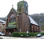 Upload another image | |||
| School Court, Former Jean Street School, Jean Street And HighHolm Street | 55°56′03″N 4°41′44″W / 55.934096°N 4.695679°W / 55.934096; -4.695679 (School Court, Former Jean Street School, Jean Street And HighHolm Street) | Category B | 40075 |  Upload another image | |||
| 6 And 8 Newark Street | 55°55′56″N 4°40′46″W / 55.932273°N 4.67954°W / 55.932273; -4.67954 (6 And 8 Newark Street) | Category B | 40077 |  Upload another image | |||
| Newark Castle, Castle Street | 55°56′04″N 4°40′41″W / 55.93458°N 4.678002°W / 55.93458; -4.678002 (Newark Castle, Castle Street) | Category A | 40069 |  Upload another image | |||
| Fore Street, Former Municipal Buildings | 55°56′05″N 4°41′15″W / 55.934732°N 4.687524°W / 55.934732; -4.687524 (Fore Street, Former Municipal Buildings) | Category A | 40071 |  Upload another image | |||
| Princes Street 49 And 65 Church Street Port Glasgow Royal Bank Building | 55°56′03″N 4°41′26″W / 55.934282°N 4.690455°W / 55.934282; -4.690455 (Princes Street 49 And 65 Church Street Port Glasgow Royal Bank Building) | Category B | 40081 |  Upload another image | |||
| Port Glasgow Harbour, Warehouses On West Quay | 55°56′11″N 4°41′20″W / 55.936503°N 4.688752°W / 55.936503; -4.688752 (Port Glasgow Harbour, Warehouses On West Quay) | Category C(S) | 40087 |  Upload another image | |||
| Former Newark Parish Church, Glen Avenue. (Halls Excluded) | 55°56′01″N 4°41′37″W / 55.933593°N 4.693594°W / 55.933593; -4.693594 (Former Newark Parish Church, Glen Avenue. (Halls Excluded)) | Category B | 40074 |  Upload another image | |||
| St Andrew's Church, Church Street,(West End),(Former Old Parish Church) | 55°56′03″N 4°41′27″W / 55.9343°N 4.690873°W / 55.9343; -4.690873 (St Andrew's Church, Church Street,(West End),(Former Old Parish Church)) | Category B | 40070 |  Upload another image | |||
| Clune Park School, Robert Street | 55°55′53″N 4°40′31″W / 55.931286°N 4.675309°W / 55.931286; -4.675309 (Clune Park School, Robert Street) | Category B | 40073 |  Upload another image | |||
| King George V1 Club, (Old Peoples' Welfare Council) 9-11 1/2 King Street | 55°56′02″N 4°41′20″W / 55.934011°N 4.688867°W / 55.934011; -4.688867 (King George V1 Club, (Old Peoples' Welfare Council) 9-11 1/2 King Street) | Category B | 40076 |  Upload another image | |||
| Parkhill Farm House, Old Greenock Road | 55°55′38″N 4°38′04″W / 55.927087°N 4.634515°W / 55.927087; -4.634515 (Parkhill Farm House, Old Greenock Road) | Category B | 40079 |  Upload another image | |||
| Port Glasgow Harbour, West Quay | 55°56′12″N 4°41′20″W / 55.936772°N 4.68877°W / 55.936772; -4.68877 (Port Glasgow Harbour, West Quay) | Category B | 40084 | Upload another image | |||
| Port Glasgow Harbour, Lighthouse Opposite Warehouse On West Quay | 55°56′15″N 4°41′15″W / 55.937482°N 4.687555°W / 55.937482; -4.687555 (Port Glasgow Harbour, Lighthouse Opposite Warehouse On West Quay) | Category B | 40086 | 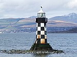 Upload another image | |||
| Bay Street/Robert Street, Gourock Ropeworks | 55°56′01″N 4°40′55″W / 55.933544°N 4.681821°W / 55.933544; -4.681821 (Bay Street/Robert Street, Gourock Ropeworks) | Category A | 40067 |  Upload another image | |||
| Former West Church Of Scotland, Brown St | 55°56′06″N 4°41′45″W / 55.934881°N 4.695909°W / 55.934881; -4.695909 (Former West Church Of Scotland, Brown St) | Category B | 40068 |  Upload another image | |||
| 2 Parkhill Avenue, Holy Family Roman Catholic Church And Presbytery | 55°55′43″N 4°39′31″W / 55.928608°N 4.658681°W / 55.928608; -4.658681 (2 Parkhill Avenue, Holy Family Roman Catholic Church And Presbytery) | Category A | 40088 |  Upload another image | |||
| Broadfield Hospital, Broadstone House, (Mental Home) Old Greenock Road | 55°55′42″N 4°38′36″W / 55.928443°N 4.643412°W / 55.928443; -4.643412 (Broadfield Hospital, Broadstone House, (Mental Home) Old Greenock Road) | Ruin | 40078 |  Upload another image | |||
| Port Glasgow Harbour, Leading Light On West Quay | 55°56′15″N 4°41′26″W / 55.937364°N 4.690509°W / 55.937364; -4.690509 (Port Glasgow Harbour, Leading Light On West Quay) | Category B | 40085 |  Upload another image | |||
| Glenpark Drive, Glenpark House | 55°56′03″N 4°42′05″W / 55.934042°N 4.701423°W / 55.934042; -4.701423 (Glenpark Drive, Glenpark House) | Category C(S) | 46409 |  Upload another image | |||
| Jean Street, Railway Bridge, Bridge Gou/29 | 55°56′05″N 4°41′46″W / 55.934758°N 4.696205°W / 55.934758; -4.696205 (Jean Street, Railway Bridge, Bridge Gou/29) | Category C(S) | 50127 | 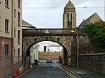 Upload another image |
Key
The scheme for classifying buildings in Scotland is:
- Category A: "buildings of national or international importance, either architectural or historic; or fine, little-altered examples of some particular period, style or building type."[1]
- Category B: "buildings of regional or more than local importance; or major examples of some particular period, style or building type, which may have been altered."[1]
- Category C: "buildings of local importance; lesser examples of any period, style, or building type, as originally constructed or moderately altered; and simple traditional buildings which group well with other listed buildings."[1]
In March 2016 there were 47,288 listed buildings in Scotland. Of these, 8% were Category A, and 50% were Category B, with the remaining 42% being Category C.[2]
See also
Notes
- ^ Sometimes known as OSGB36, the grid reference (where provided) is based on the British national grid reference system used by the Ordnance Survey.
• "Guide to National Grid". Ordnance Survey. Retrieved 12 December 2007.
• "Get-a-map". Ordnance Survey. Retrieved 17 December 2007. - ^ Historic Environment Scotland assign a unique alphanumeric identifier to each designated site in Scotland, for listed buildings this always begins with "LB", for example "LB12345".
References
- All entries, addresses and coordinates are based on data from Historic Scotland. This data falls under the Open Government Licence
- ^ a b c "What is Listing?". Historic Environment Scotland. Retrieved 29 May 2018.
- ^ Scotland's Historic Environment Audit 2016 (PDF). Historic Environment Scotland and the Built Environment Forum Scotland. pp. 15–16. Retrieved 29 May 2018.
- v
- t
- e


