List of listed buildings in Motherwell And Wishaw, North Lanarkshire
This is a list of listed buildings in the parish of Motherwell And Wishaw in North Lanarkshire, Scotland.
Map all coordinates using OpenStreetMap
Download coordinates as:
- KML
- GPX (all coordinates)
- GPX (primary coordinates)
- GPX (secondary coordinates)
List
| Name | Location | Date Listed | Grid Ref. [note 1] | Geo-coordinates | Notes | LB Number [note 2] | Image |
|---|---|---|---|---|---|---|---|
| Cambusnethan, Kirk Road, Cambusnethan Old Parish Church (Church Of Scotland) Including Church Hall, Vestry And Session House, War Memorial, Boundary Wall, Gatepiers, Gates And Railings | 55°46′36″N 3°54′16″W / 55.776732°N 3.904525°W / 55.776732; -3.904525 (Cambusnethan, Kirk Road, Cambusnethan Old Parish Church (Church Of Scotland) Including Church Hall, Vestry And Session House, War Memorial, Boundary Wall, Gatepiers, Gates And Railings) | Category C(S) | 38235 |  Upload another image | |||
| Motherwell, Manse Road, Old Dalzell Manse Including Coach House | 55°46′20″N 3°59′13″W / 55.772211°N 3.986874°W / 55.772211; -3.986874 (Motherwell, Manse Road, Old Dalzell Manse Including Coach House) | Category B | 38241 |  Upload Photo | |||
| Motherwell, South Calder Water, Jerviston Railway Viaduct | 55°48′16″N 3°59′36″W / 55.804344°N 3.993218°W / 55.804344; -3.993218 (Motherwell, South Calder Water, Jerviston Railway Viaduct) | Category B | 38242 |  Upload another image | |||
| Motherwell, 83 Camp Road, Camp Cottage (Also Known As Archibald's Temple) | 55°46′45″N 3°59′52″W / 55.779034°N 3.997825°W / 55.779034; -3.997825 (Motherwell, 83 Camp Road, Camp Cottage (Also Known As Archibald's Temple)) | Category C(S) | 38245 | Upload Photo | |||
| Wishaw, 9-35 (Odd Nos) Banchory Road, The Coach House | 55°47′09″N 3°55′03″W / 55.785735°N 3.917372°W / 55.785735; -3.917372 (Wishaw, 9-35 (Odd Nos) Banchory Road, The Coach House) | Category B | 47346 | Upload Photo | |||
| Wishaw, West Thornlie Street, Thornlie Parish Church, Church Of Scotland Former United Free Church Including Hall Gates And Boundary Walls | 55°46′19″N 3°55′21″W / 55.771949°N 3.922562°W / 55.771949; -3.922562 (Wishaw, West Thornlie Street, Thornlie Parish Church, Church Of Scotland Former United Free Church Including Hall Gates And Boundary Walls) | Category C(S) | 47505 |  Upload another image | |||
| Wishaw, 2 Belhaven Road | 55°46′35″N 3°55′41″W / 55.776339°N 3.927976°W / 55.776339; -3.927976 (Wishaw, 2 Belhaven Road) | Category B | 47936 | Upload Photo | |||
| Wishaw, 47 Clelland Road, Including Boundary Wall | 55°46′39″N 3°55′50″W / 55.777415°N 3.930421°W / 55.777415; -3.930421 (Wishaw, 47 Clelland Road, Including Boundary Wall) | Category B | 47939 | Upload Photo | |||
| Wishaw, 161 Kirk Road Including Boundary Wall | 55°46′37″N 3°54′49″W / 55.77704°N 3.913612°W / 55.77704; -3.913612 (Wishaw, 161 Kirk Road Including Boundary Wall) | Category C(S) | 47946 | Upload Photo | |||
| Wishaw, 2 Kirk Road | 55°46′24″N 3°55′09″W / 55.773458°N 3.919129°W / 55.773458; -3.919129 (Wishaw, 2 Kirk Road) | Category B | 47949 | Upload Photo | |||
| Wishaw, 177-191(Odd Nos) Main Street And 2-20 (Even) Belhaven Terrace, Cylde Chambers | 55°46′32″N 3°55′26″W / 55.775585°N 3.923937°W / 55.775585; -3.923937 (Wishaw, 177-191(Odd Nos) Main Street And 2-20 (Even) Belhaven Terrace, Cylde Chambers) | Category C(S) | 47953 | Upload Photo | |||
| Wishaw, Stewarton Street, Stewarton Street Park, Marker Post | 55°46′03″N 3°54′32″W / 55.767488°N 3.90892°W / 55.767488; -3.90892 (Wishaw, Stewarton Street, Stewarton Street Park, Marker Post) | Category C(S) | 47961 | Upload Photo | |||
| Wishaw, 11 Walter Street | 55°46′35″N 3°54′19″W / 55.776271°N 3.905284°W / 55.776271; -3.905284 (Wishaw, 11 Walter Street) | Category C(S) | 47964 | Upload Photo | |||
| Motherwell, 33 And 35 Hamilton Road, Motherwell Public Library | 55°47′21″N 3°59′39″W / 55.789294°N 3.994124°W / 55.789294; -3.994124 (Motherwell, 33 And 35 Hamilton Road, Motherwell Public Library) | Category B | 48307 | 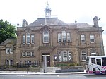 Upload another image | |||
| Wishaw, 59-69 (Odd Nos) Kirk Road, Mecca Bingo (Formerly Green's Playhouse) | 55°46′28″N 3°55′06″W / 55.774493°N 3.918462°W / 55.774493; -3.918462 (Wishaw, 59-69 (Odd Nos) Kirk Road, Mecca Bingo (Formerly Green's Playhouse)) | Category C(S) | 49605 | Upload Photo | |||
| Motherwell, Dalzell Park, Gazebo | 55°46′17″N 3°59′08″W / 55.771521°N 3.985643°W / 55.771521; -3.985643 (Motherwell, Dalzell Park, Gazebo) | Category C(S) | 38240 | Upload Photo | |||
| Motherwell, 78 Muir Street, Gospel Literature Outreach Centre (Formerly Dalziel Free Church) Including Church Hall, Manse And Boundary Wall | 55°47′31″N 3°59′36″W / 55.791888°N 3.99322°W / 55.791888; -3.99322 (Motherwell, 78 Muir Street, Gospel Literature Outreach Centre (Formerly Dalziel Free Church) Including Church Hall, Manse And Boundary Wall) | Category B | 38244 |  Upload another image | |||
| Wishaw, 57-59 (Odd Nos) Main Street | 55°46′27″N 3°55′16″W / 55.774092°N 3.921121°W / 55.774092; -3.921121 (Wishaw, 57-59 (Odd Nos) Main Street) | Category C(S) | 47951 | Upload Photo | |||
| Wishaw, 231 - 257 (Odd Nos) Main Street | 55°46′33″N 3°55′30″W / 55.775971°N 3.925088°W / 55.775971; -3.925088 (Wishaw, 231 - 257 (Odd Nos) Main Street) | Category C(S) | 47954 | Upload Photo | |||
| Wishaw, 206-216 (Even Numbers) Main Street | 55°46′32″N 3°55′23″W / 55.775643°N 3.923095°W / 55.775643; -3.923095 (Wishaw, 206-216 (Even Numbers) Main Street) | Category C(S) | 47958 | Upload Photo | |||
| Wishaw, Young Street, St Ignatius Roman Catholic Church Including Boundary Wall And Gate Pier | 55°46′28″N 3°54′55″W / 55.774407°N 3.915333°W / 55.774407; -3.915333 (Wishaw, Young Street, St Ignatius Roman Catholic Church Including Boundary Wall And Gate Pier) | Category A | 47975 | Upload Photo | |||
| Motherwell, Burnside Street, Burngrange Lodge Including Boundary Wall And Gate Piers | 55°46′38″N 3°58′15″W / 55.777287°N 3.970804°W / 55.777287; -3.970804 (Motherwell, Burnside Street, Burngrange Lodge Including Boundary Wall And Gate Piers) | Category C(S) | 48300 | Upload Photo | |||
| Motherwell, 114 Hamilton Road, The Moorings House Hotel | 55°47′19″N 3°59′53″W / 55.788545°N 3.998185°W / 55.788545; -3.998185 (Motherwell, 114 Hamilton Road, The Moorings House Hotel) | Category C(S) | 48308 | Upload Photo | |||
| Motherwell, 225 Manse Road, North Lodge Including Gatepiers, Gate And Railings | 55°46′35″N 3°59′03″W / 55.776252°N 3.984289°W / 55.776252; -3.984289 (Motherwell, 225 Manse Road, North Lodge Including Gatepiers, Gate And Railings) | Category C(S) | 48310 | 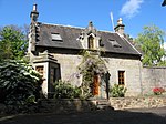 Upload another image | |||
| Motherwell, 344 Muir Street (Formerly St Andrews Parish Church) | 55°47′40″N 3°59′47″W / 55.794516°N 3.996337°W / 55.794516; -3.996337 (Motherwell, 344 Muir Street (Formerly St Andrews Parish Church)) | Category C(S) | 48313 | Upload Photo | |||
| Motherwell, 15 Orchard Street, Crosshill Manse Including Boundary Wall And Gate Piers | 55°47′23″N 3°59′50″W / 55.789597°N 3.99709°W / 55.789597; -3.99709 (Motherwell, 15 Orchard Street, Crosshill Manse Including Boundary Wall And Gate Piers) | Category B | 48314 | Upload Photo | |||
| Motherwell, Windmillhill Street, South Dalziel Parish Church (Church Of Scotland) Including Vestry, Session House, Church Hall And Boundary Wall | 55°47′02″N 3°58′48″W / 55.783815°N 3.980033°W / 55.783815; -3.980033 (Motherwell, Windmillhill Street, South Dalziel Parish Church (Church Of Scotland) Including Vestry, Session House, Church Hall And Boundary Wall) | Category B | 38237 |  Upload another image | |||
| Wishaw, Glen Road, Belhaven Estate, The Coach House | 55°47′10″N 3°56′10″W / 55.785981°N 3.936044°W / 55.785981; -3.936044 (Wishaw, Glen Road, Belhaven Estate, The Coach House) | Category C(S) | 47942 | Upload Photo | |||
| Wishaw, Kenilworth Avenue, Reformed Presbyterian Church Including Boundary Wall And Railings | 55°46′30″N 3°55′14″W / 55.774972°N 3.92059°W / 55.774972; -3.92059 (Wishaw, Kenilworth Avenue, Reformed Presbyterian Church Including Boundary Wall And Railings) | Category C(S) | 47944 | Upload Photo | |||
| Wishaw, 9 Kenilworth Avenue, Reformed Presbertyrian Church Manse | 55°46′30″N 3°55′16″W / 55.775128°N 3.920997°W / 55.775128; -3.920997 (Wishaw, 9 Kenilworth Avenue, Reformed Presbertyrian Church Manse) | Category C(S) | 47945 | Upload Photo | |||
| Wishaw, 155-175 (Odd Nos) Main Street And 1-11 (Odd Nos) Belhaven Terrace, Richmond Place | 55°46′31″N 3°55′24″W / 55.775369°N 3.923384°W / 55.775369; -3.923384 (Wishaw, 155-175 (Odd Nos) Main Street And 1-11 (Odd Nos) Belhaven Terrace, Richmond Place) | Category B | 47952 | Upload Photo | |||
| Wishaw, 40-50 (Even Nos) Main St | 55°46′27″N 3°55′12″W / 55.774036°N 3.920082°W / 55.774036; -3.920082 (Wishaw, 40-50 (Even Nos) Main St) | Category C(S) | 47957 | Upload Photo | |||
| Wishaw, 5 Stewarton Street | 55°46′24″N 3°55′08″W / 55.773372°N 3.918917°W / 55.773372; -3.918917 (Wishaw, 5 Stewarton Street) | Category C(S) | 47962 | Upload Photo | |||
| Cambusnethan, Kirk Road, Cambusnethan North Parish Church Including Church Hall And Boundary Wall (Church Of Scotland Formerly Free Church) | 55°46′38″N 3°54′09″W / 55.777124°N 3.902423°W / 55.777124; -3.902423 (Cambusnethan, Kirk Road, Cambusnethan North Parish Church Including Church Hall And Boundary Wall (Church Of Scotland Formerly Free Church)) | Category C(S) | 48015 | Upload Photo | |||
| Motherwell, Avon Street, Holy Trinity Episcopal Church | 55°47′18″N 3°59′42″W / 55.788265°N 3.994965°W / 55.788265; -3.994965 (Motherwell, Avon Street, Holy Trinity Episcopal Church) | Category C(S) | 48296 | Upload Photo | |||
| Motherwell, Dalzell Park, St Patrick's Well | 55°46′17″N 3°59′09″W / 55.77132°N 3.985808°W / 55.77132; -3.985808 (Motherwell, Dalzell Park, St Patrick's Well) | Category C(S) | 48303 |  Upload another image | |||
| Motherwell, Windmillhill Street, Drinking Fountain | 55°47′10″N 3°59′05″W / 55.786174°N 3.984794°W / 55.786174; -3.984794 (Motherwell, Windmillhill Street, Drinking Fountain) | Category C(S) | 48316 | Upload Photo | |||
| Motherwell, 2-44 (Even Nos) Scott Street And 64 Dalziel Street (Former Dalziel Co-Operative Society Building) | 55°47′32″N 3°59′12″W / 55.792102°N 3.986659°W / 55.792102; -3.986659 (Motherwell, 2-44 (Even Nos) Scott Street And 64 Dalziel Street (Former Dalziel Co-Operative Society Building)) | Category B | 38246 | Upload Photo | |||
| Wishaw, Ballater Crescent, Marker Post | 55°47′02″N 3°54′58″W / 55.783985°N 3.916074°W / 55.783985; -3.916074 (Wishaw, Ballater Crescent, Marker Post) | Category C(S) | 47935 | Upload Photo | |||
| Wishaw, 19-21 Campbell Street | 55°46′30″N 3°54′52″W / 55.774889°N 3.914432°W / 55.774889; -3.914432 (Wishaw, 19-21 Campbell Street) | Category C(S) | 47937 | Upload Photo | |||
| Wishaw, 2 Coltness Road And 279 Kirk Road | 55°46′40″N 3°54′26″W / 55.777896°N 3.907101°W / 55.777896; -3.907101 (Wishaw, 2 Coltness Road And 279 Kirk Road) | Category C(S) | 47940 | Upload Photo | |||
| Wishaw, 32-38 (Even Nos) Main Street | 55°46′26″N 3°55′12″W / 55.774002°N 3.919985°W / 55.774002; -3.919985 (Wishaw, 32-38 (Even Nos) Main Street) | Category C(S) | 47956 | Upload Photo | |||
| Wishaw, 147 Stewarton Street, Coltness Masonic Lodge | 55°46′17″N 3°54′54″W / 55.771332°N 3.914879°W / 55.771332; -3.914879 (Wishaw, 147 Stewarton Street, Coltness Masonic Lodge) | Category C(S) | 47963 | Upload Photo | |||
| Motherwell, 301 Brandon Street, Motherwell Ymca | 55°47′13″N 3°59′07″W / 55.786964°N 3.985408°W / 55.786964; -3.985408 (Motherwell, 301 Brandon Street, Motherwell Ymca) | Category B | 48299 | Upload Photo | |||
| Motherwell, 23-27 Hope Street, Motherwell Masonic Halls | 55°47′33″N 3°59′37″W / 55.792374°N 3.993739°W / 55.792374; -3.993739 (Motherwell, 23-27 Hope Street, Motherwell Masonic Halls) | Category C(S) | 48309 | Upload Photo | |||
| Motherwell, Merry Street, Dalziel Parish Church ( Church Of Scotland) Including Church Hall And Boundary Wall | 55°47′28″N 3°59′32″W / 55.791242°N 3.992086°W / 55.791242; -3.992086 (Motherwell, Merry Street, Dalziel Parish Church ( Church Of Scotland) Including Church Hall And Boundary Wall) | Category B | 48311 | Upload Photo | |||
| Wishaw, 6 West Thornlie St, Thornile Manse | 55°46′20″N 3°55′20″W / 55.772276°N 3.922339°W / 55.772276; -3.922339 (Wishaw, 6 West Thornlie St, Thornile Manse) | Category B | 45577 | Upload Photo | |||
| Wishaw, Main Street, Wishaw Old Parish Church (Church Of Scotland) | 55°46′31″N 3°55′18″W / 55.775187°N 3.921797°W / 55.775187; -3.921797 (Wishaw, Main Street, Wishaw Old Parish Church (Church Of Scotland)) | Category B | 47504 | Upload Photo | |||
| Wishaw 3-19 (Odd Nos) Main Street And 2 Caledonian Road | 55°46′25″N 3°55′12″W / 55.773518°N 3.919929°W / 55.773518; -3.919929 (Wishaw 3-19 (Odd Nos) Main Street And 2 Caledonian Road) | Category C(S) | 47950 | Upload Photo | |||
| Calder Bridge, Wishaw Low Road And Glen Road, Wishaw | 55°47′08″N 3°55′40″W / 55.785627°N 3.927701°W / 55.785627; -3.927701 (Calder Bridge, Wishaw Low Road And Glen Road, Wishaw) | Category C(S) | 48014 | 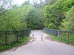 Upload another image | |||
| Motherwell, Windmillhill Street, Motherwell Baptist Church Including Church Hall | 55°47′10″N 3°59′03″W / 55.785988°N 3.984067°W / 55.785988; -3.984067 (Motherwell, Windmillhill Street, Motherwell Baptist Church Including Church Hall) | Category C(S) | 48317 | Upload Photo | |||
| 141-145 (Odd Nos) Main Street, Ymca Building | 55°46′30″N 3°55′23″W / 55.77506°N 3.923002°W / 55.77506; -3.923002 (141-145 (Odd Nos) Main Street, Ymca Building) | Category C(S) | 49232 | Upload Photo | |||
| Cambusnethan, Kirk Road, Former Parish Church Including Boundary Wall And Cemetery (Church Of Scotland) | 55°46′37″N 3°54′13″W / 55.776888°N 3.903719°W / 55.776888; -3.903719 (Cambusnethan, Kirk Road, Former Parish Church Including Boundary Wall And Cemetery (Church Of Scotland)) | Category B | 38236 | Upload Photo | |||
| Motherwell, Dalzell Park, Hamilton Of Dalzell Mausoleum And St Patrick's Graveyard Including Boundary Walls | 55°46′16″N 3°59′10″W / 55.771036°N 3.986145°W / 55.771036; -3.986145 (Motherwell, Dalzell Park, Hamilton Of Dalzell Mausoleum And St Patrick's Graveyard Including Boundary Walls) | Category B | 38239 |  Upload another image | |||
| Motherwell, Mill Road, The Old Mill Hotel (Formerly Motherwell Mill) | 55°47′56″N 3°59′06″W / 55.798915°N 3.984948°W / 55.798915; -3.984948 (Motherwell, Mill Road, The Old Mill Hotel (Formerly Motherwell Mill)) | Category C(S) | 38243 | Upload Photo | |||
| Wishaw, Glasgow Road, St Patricks Roman Catholic Church And Presbytery Including Stone Steps And Concourse | 55°46′46″N 3°57′22″W / 55.779526°N 3.956087°W / 55.779526; -3.956087 (Wishaw, Glasgow Road, St Patricks Roman Catholic Church And Presbytery Including Stone Steps And Concourse) | Category C(S) | 47941 |  Upload another image | |||
| Wishaw, 325 North Dryburgh Road, Bellside Lodge Including Boundary Wall And Railings | 55°47′39″N 3°54′49″W / 55.79408°N 3.913571°W / 55.79408; -3.913571 (Wishaw, 325 North Dryburgh Road, Bellside Lodge Including Boundary Wall And Railings) | Category C(S) | 47960 | Upload Photo | |||
| Motherwell, Crawford Street, Dalziel High School | 55°47′13″N 4°00′00″W / 55.787051°N 4.000022°W / 55.787051; -4.000022 (Motherwell, Crawford Street, Dalziel High School) | Category C(S) | 48302 | Upload Photo | |||
| Motherwell, Park Street, Dalzell Steelworks: Offices And Workshops Fronting Park Street | 55°47′19″N 3°58′58″W / 55.788492°N 3.982647°W / 55.788492; -3.982647 (Motherwell, Park Street, Dalzell Steelworks: Offices And Workshops Fronting Park Street) | Category B | 48315 | Upload Photo | |||
| Wishaw, 57 Kirk Road, Former Cinema | 55°46′27″N 3°55′08″W / 55.77429°N 3.918787°W / 55.77429; -3.918787 (Wishaw, 57 Kirk Road, Former Cinema) | Category C(S) | 49604 | Upload Photo | |||
| Wishaw, Belhaven Terrace, St Andrews Episcopal Church Including Boundary Wall | 55°46′30″N 3°55′25″W / 55.774914°N 3.923728°W / 55.774914; -3.923728 (Wishaw, Belhaven Terrace, St Andrews Episcopal Church Including Boundary Wall) | Category C(S) | 45605 | Upload Photo | |||
| Motherwell, Dalzell House Including Wellhead, Coach House, Stables And Terraced Garden | 55°46′20″N 3°58′41″W / 55.772243°N 3.978186°W / 55.772243; -3.978186 (Motherwell, Dalzell House Including Wellhead, Coach House, Stables And Terraced Garden) | Category A | 38238 | Upload Photo | |||
| Wishaw, East Academy Street, Chalmers Parish Church Including Church Hall And Boundary Wall (Church Of Scotland Formerly United Presbertyrian) | 55°46′20″N 3°55′08″W / 55.772239°N 3.918957°W / 55.772239; -3.918957 (Wishaw, East Academy Street, Chalmers Parish Church Including Church Hall And Boundary Wall (Church Of Scotland Formerly United Presbertyrian)) | Category C(S) | 47503 |  Upload another image | |||
| Wishaw, 307 Kirk Road, Vine Cottage | 55°46′39″N 3°54′18″W / 55.777509°N 3.904866°W / 55.777509; -3.904866 (Wishaw, 307 Kirk Road, Vine Cottage) | Category C(S) | 47948 | Upload Photo | |||
| Wishaw, 26-30 (Even Nos) Main Street | 55°46′26″N 3°55′11″W / 55.773888°N 3.919804°W / 55.773888; -3.919804 (Wishaw, 26-30 (Even Nos) Main Street) | Category C(S) | 47955 | Upload Photo | |||
| Wishaw, Main Street And Kenilworth Avenue Former Coltness Gatehouse | 55°46′28″N 3°55′15″W / 55.774474°N 3.920853°W / 55.774474; -3.920853 (Wishaw, Main Street And Kenilworth Avenue Former Coltness Gatehouse) | Category B | 47959 | Upload Photo | |||
| Motherwell, Brandon Street, Evangelical Union Congregational Church Including Boundary Wall And Gatepiers | 55°47′16″N 3°59′11″W / 55.787737°N 3.9865°W / 55.787737; -3.9865 (Motherwell, Brandon Street, Evangelical Union Congregational Church Including Boundary Wall And Gatepiers) | Category C(S) | 48297 | Upload Photo | |||
| Motherwell, Coursington Road, Our Lady Of Good Aid, Roman Catholic Cathedral Including Presbytery, Boundary Wall, Gatepiers And Railings | 55°47′29″N 3°59′14″W / 55.791349°N 3.987099°W / 55.791349; -3.987099 (Motherwell, Coursington Road, Our Lady Of Good Aid, Roman Catholic Cathedral Including Presbytery, Boundary Wall, Gatepiers And Railings) | Category B | 48301 | Upload Photo | |||
| Motherwell, Dalzell Park, The Sow Bridge Including Feeder Pond, Rill And Cascade | 55°46′21″N 3°58′56″W / 55.772598°N 3.98235°W / 55.772598; -3.98235 (Motherwell, Dalzell Park, The Sow Bridge Including Feeder Pond, Rill And Cascade) | Category C(S) | 48304 |  Upload another image | |||
| Motherwell, Hamilton Road, Former Motherwell Town Hall | 55°47′23″N 3°59′40″W / 55.7898°N 3.994517°W / 55.7898; -3.994517 (Motherwell, Hamilton Road, Former Motherwell Town Hall) | Category C(S) | 48305 |  Upload another image | |||
| Motherwell 1 Hamilton Road And 1, 3-15 (Odd Nos) Muir Street | 55°47′26″N 3°59′36″W / 55.790495°N 3.993244°W / 55.790495; -3.993244 (Motherwell 1 Hamilton Road And 1, 3-15 (Odd Nos) Muir Street) | Category C(S) | 48306 | Upload Photo | |||
| Motherwell, 31-37 (Odd Nos) Merry Street, The Railway Tavern | 55°47′28″N 3°59′32″W / 55.791052°N 3.992156°W / 55.791052; -3.992156 (Motherwell, 31-37 (Odd Nos) Merry Street, The Railway Tavern) | Category C(S) | 48312 | Upload Photo | |||
| Wishaw, 43-45 Clelland Road Including Boundary Wall | 55°46′38″N 3°55′50″W / 55.777172°N 3.930441°W / 55.777172; -3.930441 (Wishaw, 43-45 Clelland Road Including Boundary Wall) | Category C(S) | 47938 | Upload Photo | |||
| Wishaw, 9 Glencairn Avenue, Craigneuk | 55°46′45″N 3°57′15″W / 55.779054°N 3.954102°W / 55.779054; -3.954102 (Wishaw, 9 Glencairn Avenue, Craigneuk) | Category C(S) | 47943 | Upload Photo | |||
| Wishaw, 177 Kirk Road Including Boundary Wall | 55°46′38″N 3°54′43″W / 55.777091°N 3.912052°W / 55.777091; -3.912052 (Wishaw, 177 Kirk Road Including Boundary Wall) | Category C(S) | 47947 | Upload Photo | |||
| Wishaw, Waterloo Dimsdale Road, Pather Farmhouse | 55°45′45″N 3°54′38″W / 55.762503°N 3.910509°W / 55.762503; -3.910509 (Wishaw, Waterloo Dimsdale Road, Pather Farmhouse) | Category B | 47974 | Upload Photo | |||
| Motherwell, 273-287(Odd), 291 And 293 Brandon Street | 55°47′13″N 3°59′09″W / 55.787048°N 3.985747°W / 55.787048; -3.985747 (Motherwell, 273-287(Odd), 291 And 293 Brandon Street) | Category C(S) | 48298 | Upload Photo |
Key
The scheme for classifying buildings in Scotland is:
- Category A: "buildings of national or international importance, either architectural or historic; or fine, little-altered examples of some particular period, style or building type."[1]
- Category B: "buildings of regional or more than local importance; or major examples of some particular period, style or building type, which may have been altered."[1]
- Category C: "buildings of local importance; lesser examples of any period, style, or building type, as originally constructed or moderately altered; and simple traditional buildings which group well with other listed buildings."[1]
In March 2016 there were 47,288 listed buildings in Scotland. Of these, 8% were Category A, and 50% were Category B, with the remaining 42% being Category C.[2]
See also
Notes
- ^ Sometimes known as OSGB36, the grid reference (where provided) is based on the British national grid reference system used by the Ordnance Survey.
• "Guide to National Grid". Ordnance Survey. Retrieved 12 December 2007.
• "Get-a-map". Ordnance Survey. Retrieved 17 December 2007. - ^ Historic Environment Scotland assign a unique alphanumeric identifier to each designated site in Scotland, for listed buildings this always begins with "LB", for example "LB12345".
References
- All entries, addresses and coordinates are based on data from Historic Scotland. This data falls under the Open Government Licence
- ^ a b c "What is Listing?". Historic Environment Scotland. Retrieved 29 May 2018.
- ^ Scotland's Historic Environment Audit 2016 (PDF). Historic Environment Scotland and the Built Environment Forum Scotland. pp. 15–16. Retrieved 29 May 2018.


