List of listed buildings in Lossiemouth, Moray
This is a list of listed buildings in the parish of Lossiemouth in Moray, Scotland.
Map all coordinates using OpenStreetMap
Download coordinates as:
- KML
- GPX (all coordinates)
- GPX (primary coordinates)
- GPX (secondary coordinates)
List
| Name | Location | Date Listed | Grid Ref. [note 1] | Geo-coordinates | Notes | LB Number [note 2] | Image |
|---|---|---|---|---|---|---|---|
| Coulardbank Road, The Wardens And The Leas (Former General Assembly Schools) And Garden Walls | 57°42′59″N 3°17′28″W / 57.716381°N 3.29124°W / 57.716381; -3.29124 (Coulardbank Road, The Wardens And The Leas (Former General Assembly Schools) And Garden Walls) | Category B | 37604 |  Upload Photo | |||
| Seatown, K6 Telephone Kiosk | 57°43′00″N 3°16′52″W / 57.71669°N 3.281146°W / 57.71669; -3.281146 (Seatown, K6 Telephone Kiosk) | Category B | 37615 | Upload Photo | |||
| 15 And 16 Clifton Road | 57°43′10″N 3°16′57″W / 57.719453°N 3.282418°W / 57.719453; -3.282418 (15 And 16 Clifton Road) | Category B | 37593 | Upload Photo | |||
| 22, 24A Clifton Road | 57°43′08″N 3°17′00″W / 57.718904°N 3.28344°W / 57.718904; -3.28344 (22, 24A Clifton Road) | Category C(S) | 37595 | Upload Photo | |||
| 79, 81 Clifton Road | 57°43′01″N 3°17′18″W / 57.716941°N 3.288272°W / 57.716941; -3.288272 (79, 81 Clifton Road) | Category C(S) | 37600 | Upload Photo | |||
| The Courlard (Inn) (Formerly Couldardbank House), Garden Wall And Gatepiers | 57°42′46″N 3°18′08″W / 57.712892°N 3.302127°W / 57.712892; -3.302127 (The Courlard (Inn) (Formerly Couldardbank House), Garden Wall And Gatepiers) | Category B | 37601 | Upload Photo | |||
| Covesea Skerries Lighthouse, Keepers' Cottages And Steading | 57°43′25″N 3°20′15″W / 57.723491°N 3.337515°W / 57.723491; -3.337515 (Covesea Skerries Lighthouse, Keepers' Cottages And Steading) | Category A | 37605 | Upload Photo | |||
| 17 Moray Street, The Hillocks | 57°42′51″N 3°17′18″W / 57.714138°N 3.288374°W / 57.714138; -3.288374 (17 Moray Street, The Hillocks) | Category B | 37608 | Upload Photo | |||
| 5 Clifton Road | 57°43′12″N 3°16′53″W / 57.720021°N 3.281381°W / 57.720021; -3.281381 (5 Clifton Road) | Category C(S) | 37592 | Upload Photo | |||
| Clifton Road, Rock House Hotel (Formerly Rock Cottage) | 57°43′00″N 3°17′23″W / 57.716775°N 3.289643°W / 57.716775; -3.289643 (Clifton Road, Rock House Hotel (Formerly Rock Cottage)) | Category B | 37598 | Upload Photo | |||
| 1 Gregory Place | 57°42′59″N 3°17′03″W / 57.716328°N 3.284054°W / 57.716328; -3.284054 (1 Gregory Place) | Category B | 37606 | Upload Photo | |||
| Pitgaveny Street, Harbour Master's Offices, Lossiemouth Fisheries Museum And Associated Warehouses | 57°43′23″N 3°16′48″W / 57.723144°N 3.279896°W / 57.723144; -3.279896 (Pitgaveny Street, Harbour Master's Offices, Lossiemouth Fisheries Museum And Associated Warehouses) | Category A | 37609 | 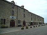 Upload another image | |||
| Prospect Terrace, Craigmount (Formerly Denmark Cottage) | 57°43′13″N 3°17′00″W / 57.720332°N 3.283457°W / 57.720332; -3.283457 (Prospect Terrace, Craigmount (Formerly Denmark Cottage)) | Category B | 37610 | Upload Photo | |||
| Seatown Bridge Over Spynie Canal | 57°43′02″N 3°16′57″W / 57.717108°N 3.28247°W / 57.717108; -3.28247 (Seatown Bridge Over Spynie Canal) | Category B | 37613 | Upload Photo | |||
| 20 Clifton Road | 57°43′08″N 3°17′00″W / 57.718985°N 3.283359°W / 57.718985; -3.283359 (20 Clifton Road) | Category B | 37594 | Upload Photo | |||
| Gregory Place, Market Cross | 57°43′00″N 3°17′04″W / 57.716701°N 3.284486°W / 57.716701; -3.284486 (Gregory Place, Market Cross) | Category B | 37607 | Upload Photo | |||
| St Gerardine's Road, St Gerardine's High Church Of Scotland, Column, Enclosing Walls And Gatepiers | 57°43′06″N 3°17′23″W / 57.71831°N 3.289764°W / 57.71831; -3.289764 (St Gerardine's Road, St Gerardine's High Church Of Scotland, Column, Enclosing Walls And Gatepiers) | Category B | 37611 |  Upload another image | |||
| 1, 2 Seatown Road And Garden Walls | 57°43′03″N 3°17′01″W / 57.717547°N 3.283476°W / 57.717547; -3.283476 (1, 2 Seatown Road And Garden Walls) | Category C(S) | 37612 | Upload Photo | |||
| Coulardbank Road, Mansefield And Garden Walls (Former Free Church Manse) | 57°42′58″N 3°17′32″W / 57.716119°N 3.292305°W / 57.716119; -3.292305 (Coulardbank Road, Mansefield And Garden Walls (Former Free Church Manse)) | Category B | 37602 | Upload Photo | |||
| Coulardbank Road, Newtown Cottage | 57°42′57″N 3°17′30″W / 57.715783°N 3.291722°W / 57.715783; -3.291722 (Coulardbank Road, Newtown Cottage) | Category C(S) | 37603 | Upload Photo | |||
| 24 Clifton Road | 57°43′08″N 3°17′00″W / 57.718778°N 3.283452°W / 57.718778; -3.283452 (24 Clifton Road) | Category B | 37596 | Upload Photo | |||
| 62 Clifton Road, The Deanery, Garden Walls And Gatepiers | 57°43′03″N 3°17′16″W / 57.717556°N 3.287857°W / 57.717556; -3.287857 (62 Clifton Road, The Deanery, Garden Walls And Gatepiers) | Category C(S) | 37597 | Upload Photo | |||
| 33 Clifton Road, Lossiemouth House | 57°43′05″N 3°17′06″W / 57.717997°N 3.285137°W / 57.717997; -3.285137 (33 Clifton Road, Lossiemouth House) | Category B | 37599 |  Upload another image | |||
| Stotfield Road, Blucairn And Sundial | 57°43′02″N 3°18′06″W / 57.71709°N 3.301791°W / 57.71709; -3.301791 (Stotfield Road, Blucairn And Sundial) | Category C(S) | 37614 | Upload Photo |
Key
The scheme for classifying buildings in Scotland is:
- Category A: "buildings of national or international importance, either architectural or historic; or fine, little-altered examples of some particular period, style or building type."[1]
- Category B: "buildings of regional or more than local importance; or major examples of some particular period, style or building type, which may have been altered."[1]
- Category C: "buildings of local importance; lesser examples of any period, style, or building type, as originally constructed or moderately altered; and simple traditional buildings which group well with other listed buildings."[1]
In March 2016 there were 47,288 listed buildings in Scotland. Of these, 8% were Category A, and 50% were Category B, with the remaining 42% being Category C.[2]
See also
Notes
- ^ Sometimes known as OSGB36, the grid reference (where provided) is based on the British national grid reference system used by the Ordnance Survey.
• "Guide to National Grid". Ordnance Survey. Retrieved 12 December 2007.
• "Get-a-map". Ordnance Survey. Retrieved 17 December 2007. - ^ Historic Environment Scotland assign a unique alphanumeric identifier to each designated site in Scotland, for listed buildings this always begins with "LB", for example "LB12345".
References
- All entries, addresses and coordinates are based on data from Historic Scotland. This data falls under the Open Government Licence
- ^ a b c "What is Listing?". Historic Environment Scotland. Retrieved 29 May 2018.
- ^ Scotland's Historic Environment Audit 2016 (PDF). Historic Environment Scotland and the Built Environment Forum Scotland. pp. 15–16. Retrieved 29 May 2018.


