List of listed buildings in Lochcarron, Highland
This is a list of listed buildings in the parish of Lochcarron in Highland, Scotland.
Map all coordinates using OpenStreetMap
Download coordinates as:
- KML
- GPX (all coordinates)
- GPX (primary coordinates)
- GPX (secondary coordinates)
List
| Name | Location | Date Listed | Grid Ref. [note 1] | Geo-coordinates | Notes | LB Number [note 2] | Image |
|---|---|---|---|---|---|---|---|
| Lochcarron Old Parish Church | 57°24′54″N 5°28′24″W / 57.414888°N 5.473375°W / 57.414888; -5.473375 (Lochcarron Old Parish Church) | Category B | 7258 | 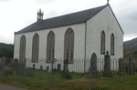 Upload another image | |||
| Balnacra, Old School And Schoolhouse | 57°27′36″N 5°22′12″W / 57.460134°N 5.370102°W / 57.460134; -5.370102 (Balnacra, Old School And Schoolhouse) | Category C(S) | 51036 |  Upload Photo | |||
| Lochcarron Free Church | 57°23′39″N 5°30′21″W / 57.394218°N 5.505917°W / 57.394218; -5.505917 (Lochcarron Free Church) | Category B | 7259 | Upload Photo | |||
| Attadale House | 57°23′40″N 5°27′11″W / 57.394349°N 5.453065°W / 57.394349; -5.453065 (Attadale House) | Category C(S) | 7254 | Upload Photo | |||
| Coulags Bridge Over Fionn-Ahainn River | 57°27′01″N 5°24′23″W / 57.450144°N 5.406284°W / 57.450144; -5.406284 (Coulags Bridge Over Fionn-Ahainn River) | Category C(S) | 7255 | Upload Photo | |||
| Tornapress Bridge Over The Allt Mor | 57°25′02″N 5°36′08″W / 57.417324°N 5.602264°W / 57.417324; -5.602264 (Tornapress Bridge Over The Allt Mor) | Category C(S) | 7266 | Upload Photo | |||
| Lochcarron, Main Street, Bank House (Halifax Royal Bank Of Scotland) Including Former Stables, Boundary Walls, Gatepiers And Railings | 57°23′54″N 5°30′00″W / 57.398363°N 5.500068°W / 57.398363; -5.500068 (Lochcarron, Main Street, Bank House (Halifax Royal Bank Of Scotland) Including Former Stables, Boundary Walls, Gatepiers And Railings) | Category B | 49299 | Upload Photo | |||
| New Kelso House | 57°25′45″N 5°26′00″W / 57.429163°N 5.433431°W / 57.429163; -5.433431 (New Kelso House) | Category A | 7262 | Upload Photo | |||
| Tullich Farm Square | 57°25′34″N 5°28′08″W / 57.426117°N 5.468774°W / 57.426117; -5.468774 (Tullich Farm Square) | Category B | 7267 | Upload Photo | |||
| Drochaid Mhor Bridge Over River Kishorn | 57°25′10″N 5°36′31″W / 57.419365°N 5.608546°W / 57.419365; -5.608546 (Drochaid Mhor Bridge Over River Kishorn) | Category C(S) | 7257 | Upload Photo | |||
| New Kelso Farm Square | 57°25′43″N 5°26′02″W / 57.428595°N 5.433828°W / 57.428595; -5.433828 (New Kelso Farm Square) | Category B | 7263 | Upload Photo | |||
| Lochcarron Hotel | 57°24′13″N 5°28′52″W / 57.403526°N 5.481159°W / 57.403526; -5.481159 (Lochcarron Hotel) | Category C(S) | 7260 | Upload Photo | |||
| Lochcarron Old Police Station | 57°24′07″N 5°29′08″W / 57.402076°N 5.485484°W / 57.402076; -5.485484 (Lochcarron Old Police Station) | Category C(S) | 7261 | Upload Photo | |||
| New Kelso Driveway Pair Estate Cottages | 57°25′38″N 5°26′15″W / 57.427172°N 5.437544°W / 57.427172; -5.437544 (New Kelso Driveway Pair Estate Cottages) | Category C(S) | 7264 | Upload Photo | |||
| Tornapress | 57°25′09″N 5°36′10″W / 57.419114°N 5.602873°W / 57.419114; -5.602873 (Tornapress) | Category C(S) | 7265 | Upload Photo | |||
| Achnashellach Lodge | 57°28′47″N 5°20′03″W / 57.479742°N 5.334161°W / 57.479742; -5.334161 (Achnashellach Lodge) | Category C(S) | 7268 | Upload Photo | |||
| Courthill Episcopal Chapel | 57°24′16″N 5°36′40″W / 57.404441°N 5.611074°W / 57.404441; -5.611074 (Courthill Episcopal Chapel) | Category C(S) | 7256 | Upload Photo |
Key
The scheme for classifying buildings in Scotland is:
- Category A: "buildings of national or international importance, either architectural or historic; or fine, little-altered examples of some particular period, style or building type."[1]
- Category B: "buildings of regional or more than local importance; or major examples of some particular period, style or building type, which may have been altered."[1]
- Category C: "buildings of local importance; lesser examples of any period, style, or building type, as originally constructed or moderately altered; and simple traditional buildings which group well with other listed buildings."[1]
In March 2016 there were 47,288 listed buildings in Scotland. Of these, 8% were Category A, and 50% were Category B, with the remaining 42% being Category C.[2]
See also
Notes
- ^ Sometimes known as OSGB36, the grid reference (where provided) is based on the British national grid reference system used by the Ordnance Survey.
• "Guide to National Grid". Ordnance Survey. Retrieved 12 December 2007.
• "Get-a-map". Ordnance Survey. Retrieved 17 December 2007. - ^ Historic Environment Scotland assign a unique alphanumeric identifier to each designated site in Scotland, for listed buildings this always begins with "LB", for example "LB12345".
References
- All entries, addresses and coordinates are based on data from Historic Scotland. This data falls under the Open Government Licence
- ^ a b c "What is Listing?". Historic Environment Scotland. Retrieved 29 May 2018.
- ^ Scotland's Historic Environment Audit 2016 (PDF). Historic Environment Scotland and the Built Environment Forum Scotland. pp. 15–16. Retrieved 29 May 2018.


