List of listed buildings in Kildonan, Highland
This is a list of listed buildings in the parish of Kildonan in Highland, Scotland.
Map all coordinates using OpenStreetMap
Download coordinates as:
- KML
- GPX (all coordinates)
- GPX (primary coordinates)
- GPX (secondary coordinates)
List
| Name | Location | Date Listed | Grid Ref. [note 1] | Geo-coordinates | Notes | LB Number [note 2] | Image |
|---|---|---|---|---|---|---|---|
| Navidale House, Garden Walls And Gatepiers | 58°07′27″N 3°37′45″W / 58.124087°N 3.629283°W / 58.124087; -3.629283 (Navidale House, Garden Walls And Gatepiers) | Category B | 12370 |  Upload Photo | |||
| Sutherland House, Sutherland Street | Helmsdale | 58°07′04″N 3°39′11″W / 58.117646°N 3.653027°W / 58.117646; -3.653027 (Sutherland House, Sutherland Street) | Category C(S) | 7186 | 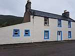 Upload another image | ||
| 3 Gartymore | 58°06′42″N 3°40′35″W / 58.111699°N 3.676413°W / 58.111699; -3.676413 (3 Gartymore) | Category B | 7202 | Upload Photo | |||
| Anvil House, Strathnaver Street | Helmsdale | 58°07′06″N 3°39′12″W / 58.118298°N 3.653261°W / 58.118298; -3.653261 (Anvil House, Strathnaver Street) | Category C(S) | 7203 |  Upload another image | ||
| Alltanduin, Winnowing Barn | 58°12′23″N 4°01′41″W / 58.206429°N 4.027951°W / 58.206429; -4.027951 (Alltanduin, Winnowing Barn) | Category C(S) | 45595 | Upload Photo | |||
| The Customs House And Ancillary Buildings, Including Rear Courtyard Walls, Shore Street | Helmsdale | 58°06′55″N 3°38′57″W / 58.115296°N 3.649269°W / 58.115296; -3.649269 (The Customs House And Ancillary Buildings, Including Rear Courtyard Walls, Shore Street) | Category B | 12914 | Upload Photo | ||
| Helmsdale Railway Station, Footbridge And Signal Box On Platform | Helmsdale | 58°07′03″N 3°39′31″W / 58.117501°N 3.658606°W / 58.117501; -3.658606 (Helmsdale Railway Station, Footbridge And Signal Box On Platform) | Category B | 7184 |  Upload another image | ||
| Feranich, Sutherland Street | Helmsdale | 58°07′03″N 3°39′10″W / 58.117543°N 3.652666°W / 58.117543; -3.652666 (Feranich, Sutherland Street) | Category C(S) | 7185 | Upload Photo | ||
| Kildonan Farm (Former Kildonan Parish Manse) | 58°09′49″N 3°51′12″W / 58.163546°N 3.853358°W / 58.163546; -3.853358 (Kildonan Farm (Former Kildonan Parish Manse)) | Category C(S) | 7189 | Upload Photo | |||
| Kilphedir Bridge Over Allt Cille Pheadair (Burn) | 58°08′42″N 3°43′05″W / 58.145048°N 3.718007°W / 58.145048; -3.718007 (Kilphedir Bridge Over Allt Cille Pheadair (Burn)) | Category C(S) | 7191 | Upload Photo | |||
| 69 and 70, Dunrobin Street | Helmsdale | 58°06′56″N 3°38′56″W / 58.115644°N 3.648776°W / 58.115644; -3.648776 (69 and 70, Dunrobin Street) | Category B | 7198 | Upload Photo | ||
| 73, Dunrobin Street | Helmsdale | 58°06′56″N 3°38′52″W / 58.115549°N 3.64777°W / 58.115549; -3.64777 (73, Dunrobin Street) | Category C(S) | 7200 | Upload Photo | ||
| Helmsdale Harbour, Shore Street, Old House To Rear 11 Shore Street | 58°06′55″N 3°39′02″W / 58.115343°N 3.65051°W / 58.115343; -3.65051 (Helmsdale Harbour, Shore Street, Old House To Rear 11 Shore Street) | Category C(S) | 7194 | Upload Photo | |||
| Ruard And Rear Service Cottage (Former Church Of Scotland Manse), Stafford Street | Helmsdale | 58°07′02″N 3°38′56″W / 58.11735°N 3.64882°W / 58.11735; -3.64882 (Ruard And Rear Service Cottage (Former Church Of Scotland Manse), Stafford Street) | Category B | 7199 | Upload Photo | ||
| The Free Church Manse, Wall And Gate Piers, Stittenham Street | Helmsdale | 58°07′08″N 3°39′16″W / 58.118866°N 3.654544°W / 58.118866; -3.654544 (The Free Church Manse, Wall And Gate Piers, Stittenham Street) | Category B | 7201 | Upload Photo | ||
| Helmsdale War Memorial | Helmsdale | 58°07′00″N 3°39′23″W / 58.116676°N 3.656445°W / 58.116676; -3.656445 (Helmsdale War Memorial) | Category C(S) | 7196 |  Upload another image | ||
| Logielea, Strathnaver Street | Helmsdale | 58°07′06″N 3°39′10″W / 58.118314°N 3.652786°W / 58.118314; -3.652786 (Logielea, Strathnaver Street) | Category C(S) | 7204 | Upload Photo | ||
| Kildonan Old Parish Church And Burial Ground | 58°09′43″N 3°51′16″W / 58.162031°N 3.854316°W / 58.162031; -3.854316 (Kildonan Old Parish Church And Burial Ground) | Category B | 7188 | Upload Photo | |||
| Kildonan Bridge Over River Helmsdale | Kildonan | 58°10′14″N 3°52′05″W / 58.170598°N 3.868143°W / 58.170598; -3.868143 (Kildonan Bridge Over River Helmsdale) | Category C(S) | 7190 |  Upload another image | ||
| Blar-Mhor (By Achentoul) | Kinbrace | 58°16′43″N 3°55′18″W / 58.278668°N 3.921652°W / 58.278668; -3.921652 (Blar-Mhor (By Achentoul)) | Category B | 7192 |  Upload another image | ||
| Masonic Lodge, Sutherland Street | Helmsdale | 58°07′04″N 3°39′12″W / 58.117877°N 3.653225°W / 58.117877; -3.653225 (Masonic Lodge, Sutherland Street) | Category C(S) | 7187 | 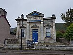 Upload another image | ||
| Old Bridge, Over River Helmsdale | Helmsdale | 58°07′00″N 3°39′18″W / 58.116658°N 3.655103°W / 58.116658; -3.655103 (Old Bridge, Over River Helmsdale) | Category A | 7193 |  Upload another image | ||
| The Bridge Hotel, Bridge Street | Helmsdale | 58°07′02″N 3°39′14″W / 58.117222°N 3.653839°W / 58.117222; -3.653839 (The Bridge Hotel, Bridge Street) | Category B | 7197 | 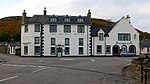 Upload another image | ||
| Helmsdale Ice House | Helmsdale | 58°07′00″N 3°39′21″W / 58.116557°N 3.655914°W / 58.116557; -3.655914 (Helmsdale Ice House) | Category B | 7195 |  Upload another image |
Key
The scheme for classifying buildings in Scotland is:
- Category A: "buildings of national or international importance, either architectural or historic; or fine, little-altered examples of some particular period, style or building type."[1]
- Category B: "buildings of regional or more than local importance; or major examples of some particular period, style or building type, which may have been altered."[1]
- Category C: "buildings of local importance; lesser examples of any period, style, or building type, as originally constructed or moderately altered; and simple traditional buildings which group well with other listed buildings."[1]
In March 2016 there were 47,288 listed buildings in Scotland. Of these, 8% were Category A, and 50% were Category B, with the remaining 42% being Category C.[2]
See also
Notes
- ^ Sometimes known as OSGB36, the grid reference (where provided) is based on the British national grid reference system used by the Ordnance Survey.
• "Guide to National Grid". Ordnance Survey. Retrieved 12 December 2007.
• "Get-a-map". Ordnance Survey. Retrieved 17 December 2007. - ^ Historic Environment Scotland assign a unique alphanumeric identifier to each designated site in Scotland, for listed buildings this always begins with "LB", for example "LB12345".
References
- All entries, addresses and coordinates are based on data from Historic Scotland. This data falls under the Open Government Licence
- ^ a b c "What is Listing?". Historic Environment Scotland. Retrieved 29 May 2018.
- ^ Scotland's Historic Environment Audit 2016 (PDF). Historic Environment Scotland and the Built Environment Forum Scotland. pp. 15–16. Retrieved 29 May 2018.


