List of listed buildings in Dunnet, Highland
This is a list of listed buildings in the parish of Dunnet in Highland, Scotland.
Map all coordinates using OpenStreetMap
Download coordinates as:
- KML
- GPX (all coordinates)
- GPX (primary coordinates)
- GPX (secondary coordinates)
List
| Name | Location | Date Listed | Grid Ref. [note 1] | Geo-coordinates | Notes | LB Number [note 2] | Image |
|---|---|---|---|---|---|---|---|
| Dunnet Head Lighthouse And Keepers' Houses With Enclosure And Gate Piers | 58°40′16″N 3°22′35″W / 58.671248°N 3.376416°W / 58.671248; -3.376416 (Dunnet Head Lighthouse And Keepers' Houses With Enclosure And Gate Piers) | Category B | 1890 |  Upload Photo | |||
| West Side, Dunnet, (Mrs Calder) | 58°37′29″N 3°21′40″W / 58.624607°N 3.360977°W / 58.624607; -3.360977 (West Side, Dunnet, (Mrs Calder)) | Category B | 6223 | Upload Photo | |||
| Dunnet Free Church Gate Piers And Enclosure Wall, Barrock | 58°37′21″N 3°16′52″W / 58.622463°N 3.281134°W / 58.622463; -3.281134 (Dunnet Free Church Gate Piers And Enclosure Wall, Barrock) | Category B | 1887 | Upload Photo | |||
| Ham Girnal And Corn Mill | 58°38′35″N 3°18′45″W / 58.643164°N 3.312595°W / 58.643164; -3.312595 (Ham Girnal And Corn Mill) | Category B | 1891 | Upload Photo | |||
| Dunnet Parish Manse | 58°37′15″N 3°20′43″W / 58.620954°N 3.345338°W / 58.620954; -3.345338 (Dunnet Parish Manse) | Category B | 1889 | Upload Photo | |||
| Rattar House | 58°38′24″N 3°17′30″W / 58.639916°N 3.2918°W / 58.639916; -3.2918 (Rattar House) | Category B | 1892 | Upload Photo | |||
| Dunnet Parish Church (Church Of Scotland) And Burial Ground | 58°37′17″N 3°20′42″W / 58.621525°N 3.344895°W / 58.621525; -3.344895 (Dunnet Parish Church (Church Of Scotland) And Burial Ground) | Category A | 1888 | 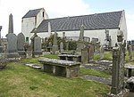 Upload another image |
Key
The scheme for classifying buildings in Scotland is:
- Category A: "buildings of national or international importance, either architectural or historic; or fine, little-altered examples of some particular period, style or building type."[1]
- Category B: "buildings of regional or more than local importance; or major examples of some particular period, style or building type, which may have been altered."[1]
- Category C: "buildings of local importance; lesser examples of any period, style, or building type, as originally constructed or moderately altered; and simple traditional buildings which group well with other listed buildings."[1]
In March 2016 there were 47,288 listed buildings in Scotland. Of these, 8% were Category A, and 50% were Category B, with the remaining 42% being Category C.[2]
See also
Notes
- ^ Sometimes known as OSGB36, the grid reference (where provided) is based on the British national grid reference system used by the Ordnance Survey.
• "Guide to National Grid". Ordnance Survey. Retrieved 12 December 2007.
• "Get-a-map". Ordnance Survey. Retrieved 17 December 2007. - ^ Historic Environment Scotland assign a unique alphanumeric identifier to each designated site in Scotland, for listed buildings this always begins with "LB", for example "LB12345".
References
- All entries, addresses and coordinates are based on data from Historic Scotland. This data falls under the Open Government Licence
- ^ a b c "What is Listing?". Historic Environment Scotland. Retrieved 29 May 2018.
- ^ Scotland's Historic Environment Audit 2016 (PDF). Historic Environment Scotland and the Built Environment Forum Scotland. pp. 15–16. Retrieved 29 May 2018.


