List of listed buildings in Creich, Highland
This is a list of listed buildings in the parish of Creich in Highland, Scotland.
Map all coordinates using OpenStreetMap
Download coordinates as:
- KML
- GPX (all coordinates)
- GPX (primary coordinates)
- GPX (secondary coordinates)
List
| Name | Location | Date Listed | Grid Ref. [note 1] | Geo-coordinates | Notes | LB Number [note 2] | Image |
|---|---|---|---|---|---|---|---|
| Bonar Bridge, Bank Of Scotland | 57°53′26″N 4°20′43″W / 57.890532°N 4.345273°W / 57.890532; -4.345273 (Bonar Bridge, Bank Of Scotland) | Category B | 285 |  Upload another image | |||
| Foot Bridge Over River Oykel, Brae Doune | 57°58′27″N 4°38′18″W / 57.974279°N 4.638387°W / 57.974279; -4.638387 (Foot Bridge Over River Oykel, Brae Doune) | Category B | 287 |  Upload another image | |||
| Creich Old Manse (Former Church Of Scotland Manse) And Walled Garden | 57°52′22″N 4°17′55″W / 57.872749°N 4.298701°W / 57.872749; -4.298701 (Creich Old Manse (Former Church Of Scotland Manse) And Walled Garden) | Category C(S) | 264 |  Upload Photo | |||
| Ospisdale House And West Gate Piers | 57°52′44″N 4°10′14″W / 57.87894°N 4.170628°W / 57.87894; -4.170628 (Ospisdale House And West Gate Piers) | Category B | 274 |  Upload another image | |||
| Balblair House Gate Lodges And Entrance Gates Only | 57°54′50″N 4°22′52″W / 57.913758°N 4.381043°W / 57.913758; -4.381043 (Balblair House Gate Lodges And Entrance Gates Only) | Category C(S) | 283 | Upload Photo | |||
| Rosehall, North Lodge And Adjoining Walls | 57°58′46″N 4°34′19″W / 57.979485°N 4.572023°W / 57.979485; -4.572023 (Rosehall, North Lodge And Adjoining Walls) | Category C(S) | 276 |  Upload another image | |||
| Bonar Bridge Migdale Hospital | 57°53′31″N 4°20′09″W / 57.891813°N 4.33579°W / 57.891813; -4.33579 (Bonar Bridge Migdale Hospital) | Category B | 284 | Upload Photo | |||
| Cassley Bridge Over River Cassley, Rosehall | 57°59′00″N 4°35′10″W / 57.983367°N 4.586156°W / 57.983367; -4.586156 (Cassley Bridge Over River Cassley, Rosehall) | Category B | 277 | 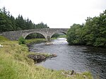 Upload another image | |||
| Bonar Bridge, Creich Parish Church | 57°53′34″N 4°20′42″W / 57.892783°N 4.345048°W / 57.892783; -4.345048 (Bonar Bridge, Creich Parish Church) | Category C(S) | 288 |  Upload another image | |||
| Migdale Free Church Wall And Gate Piers | 57°53′51″N 4°19′07″W / 57.897428°N 4.318654°W / 57.897428; -4.318654 (Migdale Free Church Wall And Gate Piers) | Category C(S) | 268 | 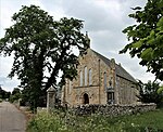 Upload another image | |||
| Migdale Mill | 57°53′45″N 4°18′48″W / 57.895772°N 4.313367°W / 57.895772; -4.313367 (Migdale Mill) | Category C(S) | 271 | Upload Photo | |||
| Migdale Mill House | 57°53′44″N 4°18′50″W / 57.895573°N 4.313962°W / 57.895573; -4.313962 (Migdale Mill House) | Category C(S) | 272 | Upload Photo | |||
| Rosehall House And Walled Garden | 57°58′38″N 4°34′50″W / 57.97729°N 4.580542°W / 57.97729; -4.580542 (Rosehall House And Walled Garden) | Category B | 275 |  Upload another image | |||
| Old Shin Bridge Over River Shin, Inveran | 57°56′39″N 4°24′33″W / 57.944248°N 4.409035°W / 57.944248; -4.409035 (Old Shin Bridge Over River Shin, Inveran) | Category B | 265 | 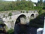 Upload another image | |||
| Invernauld Bridge Over Allt Mor Burn | 57°58′05″N 4°33′08″W / 57.968088°N 4.552115°W / 57.968088; -4.552115 (Invernauld Bridge Over Allt Mor Burn) | Category B | 266 |  Upload another image | |||
| Migdale Free Church Manse | 57°53′52″N 4°19′12″W / 57.897755°N 4.319924°W / 57.897755; -4.319924 (Migdale Free Church Manse) | Category C(S) | 270 | Upload Photo | |||
| Spinningdale, Feorlig | 57°52′44″N 4°14′15″W / 57.878999°N 4.237606°W / 57.878999; -4.237606 (Spinningdale, Feorlig) | Category B | 281 | Upload Photo | |||
| Migdale Free Church Parish Room And Adjoining Cottage | 57°53′51″N 4°19′09″W / 57.8975°N 4.319148°W / 57.8975; -4.319148 (Migdale Free Church Parish Room And Adjoining Cottage) | Category C(S) | 269 | Upload Photo | |||
| Shin Railway Viaduct Over Kyle of Sutherland | 57°55′27″N 4°24′04″W / 57.924103°N 4.40098°W / 57.924103; -4.40098 (Shin Railway Viaduct Over Kyle of Sutherland) | Category A | 279 |  Upload another image | |||
| Achinduich Old Achinduich House | 57°57′56″N 4°24′05″W / 57.965555°N 4.401301°W / 57.965555; -4.401301 (Achinduich Old Achinduich House) | Category B | 282 | Upload Photo | |||
| Bonar Bridge, Bridge End | 57°53′31″N 4°20′48″W / 57.892053°N 4.346637°W / 57.892053; -4.346637 (Bonar Bridge, Bridge End) | Category C(S) | 286 | Upload Photo | |||
| Invershin Farm And Salmon Station | 57°56′10″N 4°24′39″W / 57.936183°N 4.410707°W / 57.936183; -4.410707 (Invershin Farm And Salmon Station) | Category B | 267 | Upload Photo | |||
| Old Oykel Bridge Over River Oykel | 57°58′05″N 4°43′51″W / 57.968192°N 4.730829°W / 57.968192; -4.730829 (Old Oykel Bridge Over River Oykel) | Category B | 273 |  Upload another image | |||
| Skibo Castle, Principal Gate Lodge And Entrance Gates And Piers | 57°52′19″N 4°10′27″W / 57.871932°N 4.17427°W / 57.871932; -4.17427 (Skibo Castle, Principal Gate Lodge And Entrance Gates And Piers) | Category B | 280 |  Upload another image | |||
| Rosehall Free Church | 57°58′35″N 4°33′54″W / 57.976374°N 4.565°W / 57.976374; -4.565 (Rosehall Free Church) | Category C(S) | 278 | Upload Photo |
Key
The scheme for classifying buildings in Scotland is:
- Category A: "buildings of national or international importance, either architectural or historic; or fine, little-altered examples of some particular period, style or building type."[1]
- Category B: "buildings of regional or more than local importance; or major examples of some particular period, style or building type, which may have been altered."[1]
- Category C: "buildings of local importance; lesser examples of any period, style, or building type, as originally constructed or moderately altered; and simple traditional buildings which group well with other listed buildings."[1]
In March 2016 there were 47,288 listed buildings in Scotland. Of these, 8% were Category A, and 50% were Category B, with the remaining 42% being Category C.[2]
See also
Notes
- ^ Sometimes known as OSGB36, the grid reference (where provided) is based on the British national grid reference system used by the Ordnance Survey.
• "Guide to National Grid". Ordnance Survey. Retrieved 12 December 2007.
• "Get-a-map". Ordnance Survey. Retrieved 17 December 2007. - ^ Historic Environment Scotland assign a unique alphanumeric identifier to each designated site in Scotland, for listed buildings this always begins with "LB", for example "LB12345".
References
- All entries, addresses and coordinates are based on data from Historic Scotland. This data falls under the Open Government Licence
- ^ a b c "What is Listing?". Historic Environment Scotland. Retrieved 29 May 2018.
- ^ Scotland's Historic Environment Audit 2016 (PDF). Historic Environment Scotland and the Built Environment Forum Scotland. pp. 15–16. Retrieved 29 May 2018.


