List of landmarks of St. Louis
St. Louis Landmark is a designation of the Board of Aldermen of the City of St. Louis for historic buildings and other sites in St. Louis, Missouri. Listed sites are selected after meeting a combination of criteria, such as whether the site is a cultural resource, near a cultural resource, or contributes in aggregate to the city as a cultural resource.[1] Once a site is designated as a landmark, it is subject to the St. Louis Preservation Board, which requires that any alterations beyond routine maintenance, up to and including demolition, must have permits that are reviewed by the Board.[1] Many St. Louis Landmarks are also listed on the National Register of Historic Places, providing federal tax support for preservation, and some are further designated National Historic Landmarks, providing additional federal oversight.
Criteria
The Mayor appoints an eight-member Preservation Board to develop recommendations for landmark status in the city, which are then presented to and voted upon by the Board of Aldermen.[1] Recommendations are made based on petitions submitted to the Preservation Board by property owners, city aldermen, or the St. Louis City Cultural Resources Office (on behalf of the Preservation Board itself). The Preservation Board determines if a property is a cultural resource (and therefore is eligible for landmark status) based on whether it
- Has significant character or value as part of the development, heritage or cultural characteristics of the city, state or nation; or
- Is the site of a significant historic event; or
- Is the work of a master whose individual work has significantly influenced the development of the city, state or nation; or
- Contains elements of design, detail, materials or craftsmanship which represent a significant innovation; or
- Owing to its unique location or singular physical characteristic represents an established and familiar visual feature of a neighborhood, community or the city; or
- Has yielded, or is likely to yield, according to the best available scholarship, archaeological artifacts important in prehistory or history.
- Is a work of art located in a public space.[1]
However, Landmark property owned or controlled by the St. Louis Public Library, the St. Louis City Board of Education, Missouri or the United States government, or formerly owned or controlled by the former Art Museum Board of Control is exempt from the Preservation Board's authority.
National recognition
Several St. Louis Landmarks have been designated with National Historic Landmark status by the United States Secretary of the Interior for historical significance. All of those and a number of other districts, sites, buildings, structures, and objects worthy of preservation have been listed on the National Register of Historic Places. Not all St. Louis Landmarks have been listed on the National Register, and not all sites listed as National Historic Landmarks or listed on the National Register have been listed as St. Louis Landmarks. Additionally, St. Louis is home to Gateway Arch National Park (classed as a National Memorial) and Ulysses S. Grant National Historic Site (classed as a National Historic Site), neither of which are listed as St. Louis Landmarks.
Map all coordinates using OpenStreetMap
Download coordinates as:
- KML
- GPX (all coordinates)
- GPX (primary coordinates)
- GPX (secondary coordinates)
List of landmarks
For consistency, the list below uses the name from the list of current city landmarks on the official St. Louis government website.
| St. Louis Landmark[2] | Location | Construction[2][3] | Demolition[4] | NRHP[5] | NHL[3] | Image |
|---|---|---|---|---|---|---|
| A 19th Century House | 911 N. Tucker St. 38°38′05″N 90°11′46″W / 38.6348°N 90.1960°W / 38.6348; -90.1960 (A 19th Century House) | c. 1840 |  | |||
| Al's Restaurant | 1200 N. 1st St. 38°38′08″N 90°10′57″W / 38.635449229897375°N 90.18240402664104°W / 38.635449229897375; -90.18240402664104 (A 19th Century House) | 1872 | Upload image | |||
| Ambassador Theater | 411 N. 7th St. 38°37′46″N 90°11′28″W / 38.62952658736046°N 90.1911067203343°W / 38.62952658736046; -90.1911067203343 (A 19th Century House) | 1926 | 1996 | March 29, 1983 |  | |
| American Theatre | 416 N. 9th St. 38°37′48″N 90°11′34″W / 38.6301°N 90.1929°W / 38.6301; -90.1929 (Orpheum Theatre) | 1917 | March 18, 1985 |  | ||
| Anheuser-Busch Complex | 711 Pestalozzi St. 38°35′55″N 90°12′54″W / 38.5985°N 90.2150°W / 38.5985; -90.2150 (Anheuser-Busch Brewery) | 1859 | November 13, 1966 | November 13, 1966 |  | |
| Arcade Building | 810 Olive St. 38°37′43″N 90°11′34″W / 38.6287°N 90.1929°W / 38.6287; -90.1929 (Arcade Building) | 1919 | March 23, 2003 | 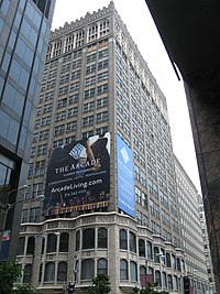 | ||
| Art Museum | 1 Fine Arts Dr. 38°38′21″N 90°17′40″W / 38.63929935090041°N 90.29448897689643°W / 38.63929935090041; -90.29448897689643 (Arcade Building) | 1904 |  | |||
| Ashley Street Power House | Ashley St. and Mississippi River 38°38′09″N 90°10′53″W / 38.6357°N 90.1815°W / 38.6357; -90.1815 (Ashley Street Power House) | 1902 |  | |||
| Bee Hat Company Building | 1021 Washington Ave. 38°37′54″N 90°11′41″W / 38.6317°N 90.1946°W / 38.6317; -90.1946 (Bee Hat Building) | 1905 | March 24, 1987 |  | ||
| Bethlehem Lutheran Church | 2153 Salisbury St. 38°39′33″N 90°12′19″W / 38.6592°N 90.2054°W / 38.6592; -90.2054 (Bethlehem Lutheran Church) | 1895 |  | |||
| Bevo Mill | 4749 Gravois Ave. 38°34′54″N 90°16′01″W / 38.5817°N 90.2670°W / 38.5817; -90.2670 (Bevo Mill) | 1917 | June 3, 2013 |  | ||
| Bissell Mansion | 4426 Randall Pl. 38°40′13″N 90°12′12″W / 38.6704°N 90.2034°W / 38.6704; -90.2034 (Lewis Bissell House) | 1823 |  | |||
| Bissell Street Water Tower | 1423 Bissell St. 38°40′13″N 90°12′20″W / 38.6704°N 90.2056°W / 38.6704; -90.2056 (Bissell Water Tower) | 1886 | June 5, 1970 |  | ||
| Campbell House | 1508 Locust St. 38°37′54″N 90°12′06″W / 38.6316°N 90.2018°W / 38.6316; -90.2018 (Campbell House Museum) | 1851 | April 20, 1977 |  | ||
| Carondelet Branch Library | 6800 Michigan Ave. 38°33′17″N 90°15′15″W / 38.5548°N 90.2542°W / 38.5548; -90.2542 (Carondelet Branch Public Library) | 1907 | February 21, 2006 |  | ||
| Centenary Methodist Church | N. 16th St. & Pine St. 38°37′49″N 90°12′13″W / 38.6304°N 90.2036°W / 38.6304; -90.2036 (Centenary Methodist Episcopal Church) | 1869 | January 15, 1977 |  | ||
| Central Baptist Church | 2842 Washington Blvd. 38°38′09″N 90°13′09″W / 38.63594070944462°N 90.21929996970084°W / 38.63594070944462; -90.21929996970084 (Centenary Methodist Episcopal Church) | 1975 |  | |||
| Central Public Library | 1301 Olive St. 38°37′50″N 90°11′58″W / 38.6306°N 90.1995°W / 38.6306; -90.1995 (St. Louis Public Library (Central Library Branch)) | 1912 |  | |||
| Chase Park Plaza Hotel | 212 N. Kingshighway Blvd. 38°38′42″N 90°15′52″W / 38.6449°N 90.2645°W / 38.6449; -90.2645 (Chase Park Plaza Hotel) | 1920 |  | |||
| Chatillon-DeMenil Mansion | 3352 DeMenil Pl. 38°35′33″N 90°12′58″W / 38.5925°N 90.2162°W / 38.5925; -90.2162 (Chatillon-DeMenil House) | 1849 | June 9, 1978 |  | ||
| Chemical Building | 721 Olive St. 38°37′43″N 90°11′32″W / 38.6285°N 90.1921°W / 38.6285; -90.1921 (Chemical Building) | 1896 | March 19, 1982 |  | ||
| Christ Baptist Church | 3114 Lismore Ave. 38°39′23″N 90°12′41″W / 38.6565°N 90.2113°W / 38.6565; -90.2113 (Christ Baptist Church) | 1896 |  | |||
| Christ Church Cathedral | 1210 Locust St. 38°37′50″N 90°11′54″W / 38.6305°N 90.1984°W / 38.6305; -90.1984 (Christ Church Cathedral) | 1867 | March 7, 1990 | October 12, 1994 |  | |
| Christian Peper Building (Raeder Place) | 721–27 N. 1st St. 38°37′49″N 90°11′00″W / 38.6304°N 90.1832°W / 38.6304; -90.1832 (Christian Peper Building) | 1874 | August 25, 1976 |  | ||
| Church of the Messiah | 508 N. Garrison Ave. | 1879 | 1987 | September 21, 1980 |  | |
| City Hall | Tucker Blvd. & Market St. 38°37′36″N 90°11′58″W / 38.6268°N 90.1994°W / 38.6268; -90.1994 (St. Louis City Hall) | 1893 |  | |||
| Clemens House | 1849 Cass Ave. 38°38′36″N 90°12′09″W / 38.6434°N 90.2024°W / 38.6434; -90.2024 (James L. Clemens House) | 1860 | 2017 | July 19, 1984 |  | |
| Compton Hill Missionary Baptist Church | 3141 LaSalle St. 38°37′26″N 90°13′47″W / 38.62391122629253°N 90.22965933550081°W / 38.62391122629253; -90.22965933550081 (James L. Clemens House) | c. 1892 | Upload image | |||
| Compton Hill Water Tower | Grand Blvd. & Russell Blvd. 38°36′54″N 90°14′20″W / 38.6150°N 90.2389°W / 38.6150; -90.2389 (Compton Hill Water Tower) | 1899 | September 29, 1972 |  | ||
| Convent of Sisters of St. Joseph | 6400 Minnesota Ave. 38°33′23″N 90°15′02″W / 38.5565°N 90.2506°W / 38.5565; -90.2506 (Sisters of St. Joseph Convent) | 1841 | February 28, 1980 |  | ||
| Cupples House | 3673 W. Pine Blvd. 38°38′12″N 90°14′09″W / 38.6367°N 90.2357°W / 38.6367; -90.2357 (Cupples House) | 1890 | July 7, 1978 |  | ||
| Cupples Station | Clark Ave. to Interstate 64 between 8th St. to 11th St. 38°37′24″N 90°11′45″W / 38.6234°N 90.1957°W / 38.6234; -90.1957 (Cupples Station) | 1894 | June 26, 1998 |  | ||
| DeHodiamont House | 951 Maple Pl. 38°39′40″N 90°17′32″W / 38.6610°N 90.2923°W / 38.6610; -90.2923 (Emmanuel DeHodiamont House) | 1830 | December 4, 2002 |  | ||
| DeSmet Hall | 3647 West Pine Blvd. | 1898 | 1977 | Upload image | ||
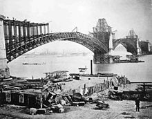
| Eads Bridge | Washington Ave. & Mississippi River 38°37′44″N 90°10′44″W / 38.6289°N 90.1790°W / 38.6289; -90.1790 (Eads Bridge) | 1874 | October 15, 1966 | January 29, 1964 |  | |
| Eastern Star Missionary Baptist Church | 3117 St. Louis Ave. 38°39′15″N 90°13′07″W / 38.654242°N 90.218561°W / 38.654242; -90.218561 (Eastern Star Missionary Baptist Church) | 1912 | December 16, 2012 |  | ||
| Eugene Field House | 635 S. Broadway 38°37′11″N 90°11′30″W / 38.6197°N 90.1917°W / 38.6197; -90.1917 (Eugene Field House) | 1845 | March 29, 2007 |  | ||
| Feasting Fox (Al Smith's) Restaurant and Pub | 4200 S. Grand Blvd. 38°34′51″N 90°14′38″W / 38.5808°N 90.2440°W / 38.5808; -90.2440 (Feasting Fox Restaurant and Pub) | 1913 | May 11, 2005 |  | ||
| Fox Theatre | 523 N. Grand Blvd. 38°38′19″N 90°13′54″W / 38.6386°N 90.2317°W / 38.6386; -90.2317 (Fox Theatre) | 1929 | October 8, 1976 |  | ||
| Goldenrod Showboat | Relocated to Calhoun County, Illinois 39°20′28″N 90°37′10″W / 39.3410°N 90.6194°W / 39.3410; -90.6194 (Goldenrod Showboat) | 1909 | 1968[6] |  | ||
| Grand Avenue (Old or White) Water Tower | 20th St. and Grand Blvd. 38°40′13″N 90°12′31″W / 38.6702°N 90.2086°W / 38.6702; -90.2086 (Grand Avenue Water Tower) | 1871 | June 15, 1970 |  | ||
| Harris Row | 18th St. between LaSalle St. & Hickory St. 38°37′09″N 90°12′37″W / 38.6193°N 90.2103°W / 38.6193; -90.2103 (Harris Row) | c. 1874 | June 28, 1972 |  | ||
| Hartley B. Comfort Building | 920 Olive St. 38°37′45″N 90°11′40″W / 38.6291°N 90.1945°W / 38.6291; -90.1945 (Bell Telephone Building) | 1889 | August 5, 1999 |  | ||
| Henry Shaw's Country House | Missouri Botanical Garden 38°36′42″N 90°15′30″W / 38.6116°N 90.2584°W / 38.6116; -90.2584 (Henry Shaw's Country House) | 1849 | November 19, 1971 |  | ||
| Henry Shaw's Town House | Missouri Botanical Garden 38°36′39″N 90°15′28″W / 38.6107°N 90.2579°W / 38.6107; -90.2579 (Henry Shaw's Town House) | 1850 | November 19, 1971 |  | ||
| Holy Corners | Kingshighway Blvd. between Westminster Pl. & Washington Ave. 38°39′01″N 90°15′49″W / 38.6504°N 90.2637°W / 38.6504; -90.2637 (Holy Corners Historic District) | 1902–1908 | December 29, 1975 |  | ||
| Holy Cross Lutheran Church | 2650 Miami St. 38°35′23″N 90°13′41″W / 38.5898°N 90.2280°W / 38.5898; -90.2280 (Holy Cross Lutheran Church) | 1867 | May 11, 2005 |  | ||
| Homer G. Phillips Hospital | 2601 Whittier Ave. 38°39′31″N 90°14′09″W / 38.6587°N 90.2358°W / 38.6587; -90.2358 (Homer G. Phillips Hospital) | 1937 | September 23, 1982 |  | ||
| Homes: 200-204 Steins and 7012 Minnesota | 200–204 W. Steins St. & 7012 Minnesota Ave. 38°32′54″N 90°15′33″W / 38.5482°N 90.2591°W / 38.5482; -90.2591 (Houses at 200-204 Steins) 38°33′09″N 90°15′18″W / 38.5525°N 90.2550°W / 38.5525; -90.2550 (House at 7012 Minnesota) | c. 1840–50 | March 27, 1980 |  | ||
| Intake Water Tower No. 1 | Mississippi River Channel 38°45′31″N 90°10′36″W / 38.7586°N 90.1768°W / 38.7586; -90.1768 (Intake Water Tower No. 1) | 1894 |  | |||
| Intake Water Tower No. 2 | Mississippi River Channel 38°45′33″N 90°10′28″W / 38.7593°N 90.1744°W / 38.7593; -90.1744 (Intake Water Tower No. 2) | 1913 |  | |||
| Jack Buck Statue | Busch Stadium 38°37′25″N 90°11′34″W / 38.6236°N 90.1927°W / 38.6236; -90.1927 (Jack Buck Statue) | 1998 |  | |||
| Jefferson Memorial (original structure) | Lindell St. & DeBaliviere Ave. 38°38′44″N 90°17′09″W / 38.6455°N 90.2857°W / 38.6455; -90.2857 (Jefferson Memorial) | 1911 |  | |||
| Kingsbury Place | Kingsbury Pl. & Kinshighway Blvd. 38°39′03″N 90°16′42″W / 38.6507°N 90.2782°W / 38.6507; -90.2782 (Kingsbury Place) | c. 1890–1910 | June 11, 2007 |  | ||
| Kulage House | 1904 E. College Ave. 38°40′34″N 90°12′46″W / 38.6762°N 90.2128°W / 38.6762; -90.2128 (Kulage House) | 1876 | May 10, 2002 |  | ||
| Lammert Furniture Building | 911 Washington Ave. 38°37′52″N 90°11′36″W / 38.6311°N 90.1933°W / 38.6311; -90.1933 (Lammert Furniture Building) | 1897 | March 24, 1987 |  | ||
| Lionberger House | 3630 Grandel Square 38°38′26″N 90°13′55″W / 38.6405°N 90.2320°W / 38.6405; -90.2320 (Lionberger House) | 1886 | July 7, 1978 |  | ||
| Lyle Mansion | Carondelet Park 38°33′36″N 90°15′45″W / 38.5601°N 90.2624°W / 38.5601; -90.2624 (Lyle Mansion) | 1842 |  | |||
| Masonic Temple | 3681 Lindell Blvd. 38°38′17″N 90°14′07″W / 38.6380°N 90.2354°W / 38.6380; -90.2354 (Masonic Hall) | 1926 | July 7, 1978 |  | ||
| Maya Angelou Birthplace | 3130 Hickory St. 38°37′21″N 90°13′47″W / 38.622613°N 90.229670°W / 38.622613; -90.229670 (Maya Angelou Birthplace) |  | ||||
| Meeting of the Waters Fountain | Aloe Plaza 38°37′48″N 90°12′28″W / 38.6299°N 90.2077°W / 38.6299; -90.2077 (Meeting of the Waters Fountain) | 1940 |  | |||
| Memorial Home | S. Grand Blvd. & Magnolia Ave. 38°36′28″N 90°14′31″W / 38.6079°N 90.2419°W / 38.6079; -90.2419 (Memorial Home) | 1867 |  | |||
| Mercantile Library Collection | Now in the Thomas Jefferson Library at UMSL | 1846 |  | |||
| Merchandise Mart Building also known as Liggett and Myers (Rice-Stix) Building | 1000 Washington Ave. 38°37′51″N 90°11′40″W / 38.6309°N 90.1944°W / 38.6309; -90.1944 (Merchandise Mart Building) | 1889 | March 24, 1987 |  | ||
| Merchants Laclede Building | 408 Olive St. 38°37′38″N 90°11′18″W / 38.6273°N 90.1883°W / 38.6273; -90.1883 (Merchants Laclede Building) | 1889 | August 5, 1978 |  | ||
| Mississippi Valley Trust Building | 401 Pine St. 38°37′36″N 90°11′18″W / 38.6268°N 90.1883°W / 38.6268; -90.1883 (Mississippi Valley Trust Building) | 1896 | May 25, 2001 |  | ||
| Missouri Athletic Club | 409 Washington Ave. 38°37′48″N 90°11′14″W / 38.6299°N 90.1873°W / 38.6299; -90.1873 (Missouri Athletic Club Building) | 1915 | April 16, 2007 |  | ||
| Most Holy Trinity Church | 3519 N. 14th St. 38°39′37″N 90°11′54″W / 38.6603°N 90.1984°W / 38.6603; -90.1984 (Most Holy Trinity Church) | 1899 |  | |||
| Naked Truth Statue | Compton Hill Reservoir Park 38°36′53″N 90°14′20″W / 38.6146°N 90.2390°W / 38.6146; -90.2390 (Naked Truth Statue) | 1914 |  | |||
| Neighborhood Gardens Apartments Complex | 1200 N. 8th St. 38°38′12″N 90°11′21″W / 38.6368°N 90.1893°W / 38.6368; -90.1893 (Neighborhood Gardens Apartments) | 1935 | January 30, 1986 |  | ||
| New Age Federal Savings & Loan | 1401 N. Kingshighway Blvd. 38°39′42″N 90°15′43″W / 38.661745°N 90.262036°W / 38.661745; -90.262036 (New Age Federal Savings & Loan) | 1958 |  | |||
| New Jerusalem Church of God in Christ at the Cathedral | 2047 E. Grand Blvd. 38°40′12″N 90°12′36″W / 38.6699°N 90.2099°W / 38.6699; -90.2099 (New Jerusalem Church of God) | 1916 |  | |||
| Old Cathedral | 209 Walnut St. 38°37′26″N 90°11′15″W / 38.6239°N 90.1876°W / 38.6239; -90.1876 (Basilica of St. Louis (Old Cathedral)) | 1834 | October 15, 1966 | 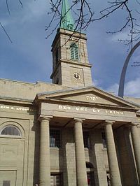 | ||
| Old Courthouse | 11 N. 4th Street 38°37′32″N 90°11′20″W / 38.6256°N 90.1888°W / 38.6256; -90.1888 (Old Courthouse) | 1859 | October 15, 1966 |  | ||
| Old May Company Department Store Building | 555 Washington Ave. 38°37′49″N 90°11′20″W / 38.6302°N 90.1890°W / 38.6302; -90.1890 (May Company Department Store Building) | 1875 | June 23, 1983 |  | ||
| Old Mutual Bank Building | 716 Locust St. 38°37′45″N 90°11′30″W / 38.6291°N 90.1917°W / 38.6291; -90.1917 (Old Mutual Bank Building) | 1917 |  | |||
| Old Post Office | 815 Olive St. 38°37′45″N 90°11′34″W / 38.629104°N 90.192797°W / 38.629104; -90.192797 (U.S. Customhouse and Post Office) | 1884 | November 22, 1968 | December 30, 1970 |  | |
| Old Strassberger Music Conservatory | 2300 S. Grand Blvd. 38°36′35″N 90°14′27″W / 38.6097°N 90.2407°W / 38.6097; -90.2407 (Strassberger's Conservatory) | 1904 |  | |||
| Oscar Waring House | 1211 Tower Grove Ave. 38°37′32″N 90°15′25″W / 38.625680288613516°N 90.25692488973546°W / 38.625680288613516; -90.25692488973546 (Strassberger's Conservatory) | c. 1881[7] | December 19, 2012 | Upload image | ||
| Page Boulevard Police Station | Northeast corner of Page Blvd. & Union Blvd. 38°39′40″N 90°16′18″W / 38.66108088281418°N 90.27163501658389°W / 38.66108088281418; -90.27163501658389 (Strassberger's Conservatory) | 1908 | 1995 | September 10, 1980 | Upload image | |
| Park Keeper's House (Cabanne House) | Forest Park 38°38′40″N 90°16′31″W / 38.6445°N 90.2754°W / 38.6445; -90.2754 (Cabanne House (Park Keeper's House)) | 1875 | June 10, 1986 |  | ||
| Pelican's Restaurant | 2256 S. Grand Ave. 38°36′36″N 90°14′26″W / 38.6100°N 90.2406°W / 38.6100; -90.2406 (Pelican's Restaurant) | 1895 |  | |||
| Pilgrim Congregational Church | 826 Union Blvd. 38°39′17″N 90°16′22″W / 38.6546°N 90.2729°W / 38.6546; -90.2729 (Pilgrim Congregational Church) | 1906 | September 13, 2002 |  | ||
| Powell Symphony Hall | 718 N. Grand Blvd. 38°38′25″N 90°13′49″W / 38.6404°N 90.2302°W / 38.6404; -90.2302 (Powell Symphony Hall) | 1925 | May 25, 2001 |  | ||
| Prince Hall Grand Lodge #2 | 3615-19 Dr. Martin Luther King Blvd. 38°38′51″N 90°13′37″W / 38.6474153397028°N 90.22706143835416°W / 38.6474153397028; -90.22706143835416 (Powell Symphony Hall) | 1886 | 1995 | 1993 | Upload image | |
| Resurrection Church | 3900 Meramec St. 38°35′03″N 90°15′06″W / 38.5843°N 90.2517°W / 38.5843; -90.2517 (Resurrection of Our Lord Catholic Church) | 1954 |  | |||
| Sacred Heart of Jesus Catholic Church | 2830 N. 25th St. 38°39′11″N 90°12′31″W / 38.65316702041597°N 90.2084920038981°W / 38.65316702041597; -90.2084920038981 (Resurrection of Our Lord Catholic Church) | 1898 | 1986 | August 30, 2011 | Upload image | |
| Schlichtig House | 300 E. Marceau St. 38°32′25″N 90°15′45″W / 38.5404°N 90.2624°W / 38.5404; -90.2624 (Schlichtig House) | 1852 | May 29, 1980 |  | ||
| Second Presbyterian Church | 4501 Westminster Pl. 38°38′51″N 90°15′21″W / 38.6475°N 90.2557°W / 38.6475; -90.2557 (Second Presbyterian Church) | 1896 | September 10, 1975 |  | ||
| Security Building | 319 N. 4th St. 38°37′41″N 90°11′16″W / 38.6280°N 90.1878°W / 38.6280; -90.1878 (Security Building) | 1890 | February 9, 2009 |  | ||
| Shaw Place | Ten Houses 38°36′58″N 90°14′31″W / 38.6160°N 90.2419°W / 38.6160; -90.2419 (Shaw Place) | 1879 | April 12, 1982 |  | ||
| Sheldon Concert Hall | 3646 Washington Ave. 38°38′24″N 90°13′59″W / 38.6399°N 90.2331°W / 38.6399; -90.2331 (Sheldon Concert Hall) | 1912 | July 7, 1978 |  | ||
| Shining Light Tabernacle (formerly Christ Church) | 7121 Manchester Rd. 38°36′58″N 90°18′40″W / 38.6160°N 90.3110°W / 38.6160; -90.3110 (Shining Light Tabernacle (formerly Christ Church)) | 1891 | November 13, 2019 |  | ||
| Soulard Market | 730 Carroll St. 38°36′39″N 90°12′03″W / 38.6109°N 90.2008°W / 38.6109; -90.2008 (Soulard Market) | 1928 | December 26, 1972 |  | ||
| South Broadway Bluff Area | c. 4500–5500 S. Broadway 38°34′01″N 90°14′18″W / 38.5669°N 90.2384°W / 38.5669; -90.2384 (South Broadway Bluff Area) |  | ||||
| SS. Peter and Paul Church | 1919 S. 7th St. 38°36′25″N 90°12′13″W / 38.607°N 90.2036°W / 38.607; -90.2036 (Sts. Peter and Paul Church) | c. 1873 | December 26, 1972 |  | ||
| St. Mark's Episcopal Church | 4712 Clifton Ave. 38°35′15″N 90°17′43″W / 38.5875°N 90.2953°W / 38.5875; -90.2953 (St. Mark's Episcopal Church) | 1939 |  | |||
| St. Alphonsus Catholic Church | 1118 N. Grand Blvd. 38°38′39″N 90°13′41″W / 38.6442°N 90.2281°W / 38.6442; -90.2281 (St. Alphonsus Catholic Church) | 1893 |  | |||
| St. Francis DeSales Church | 2653 Ohio Ave. 38°36′14″N 90°13′33″W / 38.6040°N 90.2257°W / 38.6040; -90.2257 (St. Francis de Sales Church) | 1906 | October 8, 2012 | 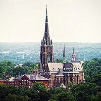 | ||
| St. Francis Xavier College Church | Lindell Blvd. & N. Grand Blvd. 38°38′13″N 90°13′59″W / 38.6370°N 90.2330°W / 38.6370; -90.2330 (St. Francis Xavier College Church) | 1898 | July 7, 1978 |  | ||
| St. John Nepomuk Church | S. 11th St. & Lafayette Ave. 38°36′44″N 90°12′19″W / 38.6123°N 90.2053°W / 38.6123; -90.2053 (St. John Nepomuk Church) | 1895 | June 19, 1972 |  | ||
| St. John the Apostle and Evangelist Church | c. 1600 Chestnut St. 38°37′46″N 90°12′13″W / 38.6295°N 90.2035°W / 38.6295; -90.2035 (St. John the Apostle and Evangelist Church) | 1869 | July 11, 2007 | 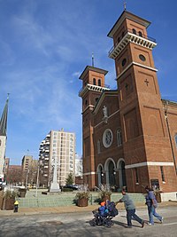 | ||
| St. Joseph Church and Parish House | 1220 N. 11th St. 38°38′13″N 90°11′34″W / 38.6370°N 90.1927°W / 38.6370; -90.1927 (Shrine of St. Joseph Catholic Church) | 1844 | May 19, 1978 |  | ||
| St. Liborius Parish Complex | 1835 N. Market St. 38°38′48″N 90°12′00″W / 38.6468°N 90.2001°W / 38.6468; -90.2001 (St. Liborius Church and Buildings) | 1857 | October 11, 1979 |  | ||
| St. Louis Cathedral | 4431 Lindell Blvd. 38°38′32″N 90°15′17″W / 38.6421°N 90.2548°W / 38.6421; -90.2548 (Cathedral Basilica of St. Louis (New Cathedral)) | 1914 |  | |||
| St. Mary of Victories Catholic Church | 744 S. 3rd St. 38°37′05″N 90°11′26″W / 38.6180°N 90.1906°W / 38.6180; -90.1906 (St. Mary of Victories Catholic Church) | 1843 | August 28, 1980 |  | ||
| St. Stanislaus Kostka Church | 1419 N. 20th St. 38°38′31″N 90°12′21″W / 38.6420°N 90.2058°W / 38.6420; -90.2058 (St. Stanislaus Kostka Church) | 1891 | July 10, 1979 |  | ||
| St. Vincent de Paul Church | 1417 S. 9th St. 38°36′48″N 90°12′02″W / 38.6133°N 90.2006°W / 38.6133; -90.2006 (St. Vincent DePaul Church) | 1844 | August 19, 1983 |  | ||
| Statue of St. Louis | Forest Park 38°38′23″N 90°17′39″W / 38.6398°N 90.2941°W / 38.6398; -90.2941 (Apotheosis of St. Louis) | 1906 |  | |||
| Steins House | Steins St. & Reilly St. 38°32′43″N 90°15′18″W / 38.5454°N 90.2550°W / 38.5454; -90.2550 (Jacob Steins House) | 1843 | May 28, 1980 |  | ||
| Stockstrom House | 3400 Russell Blvd. 38°36′46″N 90°14′10″W / 38.6127°N 90.2362°W / 38.6127; -90.2362 (Stockstrom House) | 1907 | November 8, 2018 | 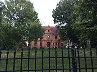 | ||
| Store buildings | 7121–7129 S. Broadway 38°33′02″N 90°15′16″W / 38.5505°N 90.2545°W / 38.5505; -90.2545 (Broadway store buildings) | 1850 | February 22, 2006 |  | ||
| T.S. Eliot House | 4446 Westminster Pl. 38°38′48″N 90°15′15″W / 38.6466°N 90.2542°W / 38.6466; -90.2542 (T.S. Eliot House) | 1904 | April 10, 1980 |  | ||
| Tillie's Corner | 1345-55 N. Garrison Ave. 38°38′40″N 90°13′13″W / 38.644499°N 90.220243°W / 38.644499; -90.220243 (Tillie's Corner) |  | ||||
| Towne Theatre | 210 N. 6th St. 38°37′38″N 90°11′24″W / 38.6272133317384°N 90.18997611030355°W / 38.6272133317384; -90.18997611030355 (Tillie's Corner) | 1896 | 1983 | Upload image | ||
| Union Avenue Christian Church | 733 Union Ave. 38°39′14″N 90°16′25″W / 38.6540°N 90.2737°W / 38.6540; -90.2737 (Union Avenue Christian Church) | 1904 |  | |||
| Union Market | 711 North Broadway 38°37′51″N 90°11′16″W / 38.6308°N 90.1879°W / 38.6308; -90.1879 (Union Market) | 1924 | January 15, 1984 |  | ||
| Union Station | 1820 Market St. 38°37′45″N 90°12′26″W / 38.6293°N 90.2073°W / 38.6293; -90.2073 (St. Louis Union Station) | 1894 | December 30, 1970 | December 30, 1970 |  | |
| Union Trust Building | 705 Olive St. 38°37′42″N 90°11′30″W / 38.6284°N 90.1916°W / 38.6284; -90.1916 (Union Trust Building) | 1892 | June 16, 1982 |  | ||
| United Missouri Bank Building | 312 N. 8th St. 38°37′44″N 90°11′31″W / 38.6290°N 90.1920°W / 38.6290; -90.1920 (United Missouri Bank Building) | 1892 | November 21, 2000 |  | ||
| Vess Advertising Device | 6th St. & O'Fallon St. 38°38′12″N 90°11′12″W / 38.6368°N 90.1868°W / 38.6368; -90.1868 (Vess Advertising Device) | 1950 |  | |||
| Veterans Administration Building | 200 N. Broadway 38°37′37″N 90°11′20″W / 38.627066051323155°N 90.1889603734836°W / 38.627066051323155; -90.1889603734836 (Vess Advertising Device) | 1907 | 1977 | Upload image | ||
| von Harten Residence | 5433 Enright Ave. 38°39′17″N 90°16′38″W / 38.6548°N 90.2771°W / 38.6548; -90.2771 (Von Harten Residence) | 1896 |  | |||
| Wainwright Building | 705 Chestnut St. 38°37′38″N 90°11′32″W / 38.6271°N 90.1921°W / 38.6271; -90.1921 (Wainwright Building) | 1892 | May 23, 1968 | May 23, 1968 | 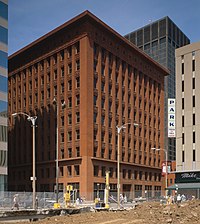 | |
| Wainwright Tomb | Bellefontaine Cemetery 38°41′23″N 90°13′30″W / 38.68961287138456°N 90.22491570517828°W / 38.68961287138456; -90.22491570517828 (Wainwright Building) | 1892 | June 15, 1970 |  | ||
| Walz House | 4708 S. Broadway 38°34′13″N 90°14′04″W / 38.57015752038704°N 90.2343941128381°W / 38.57015752038704; -90.2343941128381 (Wainwright Building) | 1849 | 1982 | June 14, 1970 | Upload image | |
| Washington Tabernacle Baptist Church | 3200 Washington Ave. 38°38′14″N 90°13′31″W / 38.6372°N 90.2254°W / 38.6372; -90.2254 (Washington Tabernacle Baptist Church) | 1879 |  | |||
| Washington Terrace | 48 Houses 38°39′06″N 90°16′25″W / 38.6516°N 90.2737°W / 38.6516; -90.2737 (Washington Terrace) | c. 1890–1910 |  | |||
| Westminster Presbyterian Church | 5300 Delmar Blvd. 38°39′09″N 90°16′26″W / 38.6524°N 90.2739°W / 38.6524; -90.2739 (Westminster Presbyterian Church) | 1925 |  | |||
| Woolworth Building | 3663 Lindell Blvd. 38°38′16″N 90°14′05″W / 38.6379°N 90.2348°W / 38.6379; -90.2348 (Saint Louis University Museum of Art) | 1899 | July 7, 1978 |  |
Historic districts
The City has 18 Local Historic Districts, 8 of which are Certified Local Historic Districts.[8]
Local historic districts
- 4100-4300 Lindell
- Benton Park
- Cherokee-Lemp Brewery
- Kingsbury-Washington Terrace
- Lafayette Square
- McKinley Heights
- North I-44
- Tower Grove East
- Union Station
- The Ville
Certified local historic districts
- Central West End
- Compton Hill
- Fox Park
- Hyde Park
- Shaw Neighborhood
- Skinker-DeBaliviere-Catlin Tract-Parkview
- Soulard Neighborhood
- Visitation Park
See also
- Landmarks of St. Louis, Missouri
- List of public art in St. Louis
- National Register of Historic Places listings in Downtown and Downtown West St. Louis
- National Register of Historic Places listings in St. Louis north and west of downtown
- National Register of Historic Places listings in St. Louis south and west of downtown
References
- ^ a b c d "St. Louis City Ordinance 64689". Laws of the City of St. Louis. Archived from the original on November 20, 2000. Retrieved February 20, 2010.
- ^ a b "List of Current City Landmarks". stlouis-mo.gov. Retrieved December 12, 2023.
- ^ a b "List of NHLs by State - National Historic Landmarks (U.S. National Park Service)". www.nps.gov. Retrieved December 13, 2023.
- ^ "City Landmarks in St. Louis". City of St. Louis Cultural Resources Office. Retrieved August 3, 2012.
- ^ "ArcGIS Web Application". modnr.maps.arcgis.com. Retrieved December 13, 2023.
- ^ "Goldenrod (Showboat, 1909-?) - UWDC - UW-Madison Libraries". search.library.wisc.edu. Retrieved December 13, 2023.
- ^ United States Department of the Interior National Park Service (March 31, 2012). "Forest-Park-Southeast-Historic-District_BI-IV.pdf" (PDF). National Register of Historic Places Registration Form: 79.
- ^ "City Historic Districts". stlouis-mo.gov. Retrieved October 15, 2023.
External links
- List of City Landmarks
- 2012 Most Endangered Landmarks


| ||
|---|---|---|
| Topics |  | |
| Central city | ||
| Largest cities (over 50,000 in 2020) | ||
| Medium-sized cities (over 20,000 in 2020) | ||
| Largest towns and villages (over 10,000 in 2020) |
| |
| Missouri counties | ||
| Illinois counties | ||
| Subregions | ||


