List of Category A listed buildings in Perth and Kinross
Map all coordinates using OpenStreetMap
Download coordinates as:
- KML
- GPX (all coordinates)
- GPX (primary coordinates)
- GPX (secondary coordinates)
This is a list of Category A listed buildings in Perth and Kinross, Scotland.
In Scotland, the term listed building refers to a building or other structure officially designated as being of "special architectural or historic interest".[1] Category A structures are those considered to be "buildings of national or international importance, either architectural or historic, or fine little-altered examples of some particular period, style or building type."[2] Listing was begun by a provision in the Town and Country Planning (Scotland) Act 1947, and the current legislative basis for listing is the Planning (Listed Buildings and Conservation Areas) (Scotland) Act 1997.[3] The authority for listing rests with Historic Scotland, an executive agency of the Scottish Government, which inherited this role from the Scottish Development Department in 1991. Once listed, severe restrictions are imposed on the modifications allowed to a building's structure or its fittings. Listed building consent must be obtained from local authorities prior to any alteration to such a structure.[3] There are approximately 47,400 listed buildings in Scotland, of which around 8% (some 3,800) are Category A.[4]
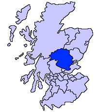
The council area of Perth and Kinross covers 5,286 square kilometres (2,041 sq mi), and has a population of around 144,200. There are 195 Category A listed buildings in the area.[5]
Listed buildings
| Name | Location | Date Listed | Grid Ref. [note 1] | Geo-coordinates | Notes | LB Number [note 2] | Image |
|---|---|---|---|---|---|---|---|
| Canal Street and Tay Street, Greyfriars Burial Ground including Gates and Boundary Walls | Perth | NO1199623263 | 56°23′37″N 3°25′38″W / 56.39367°N 3.42718°W / 56.39367; -3.42718 (Canal Street and Tay Street, Greyfriars Burial Ground including Gates and Boundary Walls) | 39338 |  Upload another image | ||
| Bridge of Ruim | Over Quiech Burn east of Alyth | NO2695349304 | 56°37′47″N 3°11′32″W / 56.629857°N 3.192274°W / 56.629857; -3.192274 (Bridge of Ruim) | Early-18th-century packhorse bridge[6] | 53 |  Upload Photo | |
| Old Fincastle House | Glen Fincastle, south of Blair Atholl | NN8678462175 | 56°44′15″N 3°51′09″W / 56.737433°N 3.852377°W / 56.737433; -3.852377 (Old Fincastle House) | 17th-century house[7] | 69 | Upload Photo | |
| Stobhall, Sundial No. 2 | North-east of Stanley | NO1325234477 | 56°29′40″N 3°24′38″W / 56.494354°N 3.410564°W / 56.494354; -3.410564 (Stobhall, Sundial No. 2) | 17th-century faceted sundial[8] | 79 | Upload Photo | |
| Drummonie House | South-west of Bridge of Earn | NO1171117088 | 56°20′16″N 3°25′47″W / 56.337892°N 3.429713°W / 56.337892; -3.429713 (Drummonie House) | Late-17th- or early-18th-century house[9] | 163 |  Upload another image | |
| Balhary House | South of Alyth | NO2643446602 | 56°36′20″N 3°12′00″W / 56.605507°N 3.199961°W / 56.605507; -3.199961 (Balhary House) | Late Georgian country house[10] | 4379 | Upload Photo | |
| Bridge of Isla | Over River Isla near Meikleour | NO1637238142 | 56°31′40″N 3°21′40″W / 56.527836°N 3.361085°W / 56.527836; -3.361085 (Bridge of Isla) | Late-18th-century five-arch bridge[11] | 4424 |  Upload another image | |
| Gourdie House | Craigie | NO1225642314 | 56°33′52″N 3°25′46″W / 56.564555°N 3.429384°W / 56.564555; -3.429384 (Gourdie House) | 18th-century house[12] | 4440 |  Upload another image | |
| Meikleour Mercat Cross | Meikleour | NO1575039530 | 56°32′25″N 3°22′18″W / 56.540191°N 3.371644°W / 56.540191; -3.371644 (Meikleour Mercat Cross) | mercat cross dated 1698[13] | 4446 |  Upload another image | |
| Stanley Mills, Bell Mill (or West Mill) | Stanley | NO1134532833 | 56°28′45″N 3°26′27″W / 56.479234°N 3.440967°W / 56.479234; -3.440967 (Stanley Mills, Bell Mill (or West Mill)) | Cotton mill of 1787, brick with iron columns, "perhaps the finest and best-preserved cotton mill with which Sir Richard Arkwright was concerned"[14] | 4486 |  Upload another image | |
| Stanley Mills, Mid Mill | Stanley | NO1137432809 | 56°28′44″N 3°26′26″W / 56.479024°N 3.440488°W / 56.479024; -3.440488 (Stanley Mills, Mid Mill) | Cotton mill of c. 1823, contains "probably the oldest cotton-spinning machinery in Scotland"[15] | 4489 | Upload another image | |
| Kilgraston House | Bridge of Earn | NO1254717502 | 56°20′30″N 3°24′59″W / 56.341766°N 3.416333°W / 56.341766; -3.416333 (Kilgraston House) | Georgian house of c. 1793[16] | 4527 |  Upload another image | |
| Aberuchill Castle | Strathearn, west of Comrie | NN7449221162 | 56°21′58″N 4°02′00″W / 56.366065°N 4.03333°W / 56.366065; -4.03333 (Aberuchill Castle) | 17th-century tower house with later additions[17] | 5296 |  Upload another image | |
| Comrie Old Parish Church | Comrie | NN7728621954 | 56°22′26″N 3°59′19″W / 56.37391°N 3.988502°W / 56.37391; -3.988502 (Comrie Old Parish Church) | Gothic church of 1805[18] | 5385 |  Upload another image | |
| 1 Dunira Street | Comrie | NN7731221995 | 56°22′27″N 3°59′17″W / 56.374284°N 3.988101°W / 56.374284; -3.988101 (1 Dunira Street) | Shop and offices, 1904 by Charles Rennie Mackintosh[19] | 5393 |  Upload another image | |
| Balmanno Castle | Aberargie | NO1435715575 | 56°19′29″N 3°23′11″W / 56.32479°N 3.386434°W / 56.32479; -3.386434 (Balmanno Castle) | 16th-century tower house[20] | 5422 | 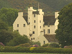 Upload another image | |
| Ecclesiamagirdle House | South-west of Bridge of Earn | NO1075616398 | 56°19′53″N 3°26′42″W / 56.331516°N 3.444921°W / 56.331516; -3.444921 (Ecclesiamagirdle House) | 17th-century T-plan house[21] | 5427 | Upload Photo | |
| Ecclesiamagirdle House: Dovecot | South-west of Bridge of Earn | NO1077416398 | 56°19′53″N 3°26′41″W / 56.33152°N 3.44463°W / 56.33152; -3.44463 (Ecclesiamagirdle House: Dovecot) | 17th-century circular dovecote[22] | 5430 | Upload Photo | |
| Balvaird Castle | Ochil Hills, east of Glenfarg | NO1698211536 | 56°17′20″N 3°20′34″W / 56.28898°N 3.342728°W / 56.28898; -3.342728 (Balvaird Castle) | Late-15th-century tower house[23] | 5466 |  Upload another image | |
| Stobhall Chapel Block | North-east of Stanley | NO1319734351 | 56°29′36″N 3°24′41″W / 56.493213°N 3.411415°W / 56.493213; -3.411415 (Stobhall Chapel Block) | 16th-century chapel and tower house[24] | 5473 | 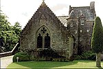 Upload another image | |
| Stobhall Laundry, Brewhouse and Bakehouse | North-east of Stanley | NO1319234364 | 56°29′36″N 3°24′41″W / 56.493328°N 3.411501°W / 56.493328; -3.411501 (Stobhall Laundry, Brewhouse and Bakehouse) | 16th- 17th-century vernacular buildings[25] | 5474 | Upload Photo | |
| Stobhall Dowery House | North-east of Stanley | NO1320834371 | 56°29′36″N 3°24′40″W / 56.493394°N 3.411243°W / 56.493394; -3.411243 (Stobhall Dowery House) | 17th-century house[26] | 5475 | Upload another image | |
| Stobhall New Library | North-east of Stanley | NO1318734339 | 56°29′35″N 3°24′42″W / 56.493103°N 3.411573°W / 56.493103; -3.411573 (Stobhall New Library) | 1965 replica of earlier building[27] | 5477 | Upload Photo | |
| Stobhall, Sundial No. 1 | North-east of Stanley | NO1321234399 | 56°29′37″N 3°24′40″W / 56.493646°N 3.411187°W / 56.493646; -3.411187 (Stobhall, Sundial No. 1) | Possibly 17th-century[28] | 5479 | Upload Photo | |
| Dunkeld Bridge | Over River Tay at Dunkeld | NO0267542453 | 56°33′50″N 3°35′07″W / 56.563913°N 3.585275°W / 56.563913; -3.585275 (Dunkeld Bridge) | Seven-arch bridge of 1809, by Thomas Telford[29] | 5620 |  Upload another image | |
| Dunkeld Cathedral | Dunkeld | NO0239342595 | 56°33′54″N 3°35′24″W / 56.56513°N 3.589916°W / 56.56513; -3.589916 (Dunkeld Cathedral) | Oldest parts are 13th-century, with additions of the 14th, 15th, 17 and 19th centuries[30] | 5631 |  Upload another image | |
| Blackcraig Bridge | Over River Ardle on Blackcraig Castle drive | NO1083453607 | 56°39′57″N 3°27′23″W / 56.665707°N 3.456415°W / 56.665707; -3.456415 (Blackcraig Bridge) | 19th-century bridge with picturesque gatehouses[31] | 5674 |  Upload another image | |
| Ardblair Castle | Blairgowrie | NO1635844530 | 56°35′07″N 3°21′48″W / 56.585206°N 3.363374°W / 56.585206; -3.363374 (Ardblair Castle) | 17th- 18th-century tower house and courtyard[32] | 5677 | Upload Photo | |
| Cleish Castle | Cleish Hills, south of Kinross | NT0824097974 | 56°09′56″N 3°28′45″W / 56.165563°N 3.4792°W / 56.165563; -3.4792 (Cleish Castle) | 16th-century tower house[33] | 5711 |  Upload another image | |
| Blair Adam | Kelty | NT1292995700 | 56°08′46″N 3°24′11″W / 56.146019°N 3.402974°W / 56.146019; -3.402974 (Blair Adam) | House of 1733 by William Adam[34] | 5715 | Upload Photo | |
| Tummel Bridge | Over River Tummel west of Loch Tummel | NN7624559180 | 56°42′28″N 4°01′23″W / 56.707866°N 4.023099°W / 56.707866; -4.023099 (Tummel Bridge) | Single-arch bridge by George Wade, c. 1734[35] | 5742 |  Upload another image | |
| Monzie Castle | Crieff | NN8737924502 | 56°23′57″N 3°49′35″W / 56.399302°N 3.826276°W / 56.399302; -3.826276 (Monzie Castle) | 17th-century tower house with 18th-century range[36] | 5779 |  Upload another image | |
| Innerpeffray Library | Innerpeffray, by Crieff | NN9018418347 | 56°20′41″N 3°46′42″W / 56.344692°N 3.778278°W / 56.344692; -3.778278 (Innerpeffray Library) | Purpose-built library completed 1762[37] | 5792 |  Upload another image | |
| Montrose Mausoleum | Aberuthven, St Kattan's Churchyard | NN9735015103 | 56°19′02″N 3°39′40″W / 56.317169°N 3.661132°W / 56.317169; -3.661132 (Montrose Mausoleum) | Mausoleum of the Dukes of Montrose, designed by John Adam in 1736[38] | 5819 |  Upload another image | |
| Clunie Castle | Loch of Clunie, Clunie | NO1132044015 | 56°34′47″N 3°26′43″W / 56.579655°N 3.445192°W / 56.579655; -3.445192 (Clunie Castle) | Ruined 16th-century tower house[39] | 5843 |  Upload another image | |
| Keltie Castle | Dunning | NO0075813274 | 56°18′05″N 3°36′19″W / 56.30147°N 3.60537°W / 56.30147; -3.60537 (Keltie Castle) | 17th-century tower house with later alterations[40] | 5912 | Upload Photo | |
| Duncrub House: Dovecot | Dunning | NO0148714967 | 56°19′01″N 3°35′39″W / 56.316826°N 3.594228°W / 56.316826; -3.594228 (Duncrub House: Dovecot) | 18th-century dovecote[41] | 5915 |  Upload another image | |
| Parish Church of St. Serf | Dunning | NO0190514490 | 56°18′45″N 3°35′14″W / 56.312629°N 3.587295°W / 56.312629; -3.587295 (Parish Church of St. Serf) | Medieval church[42] | 52454 |  Upload another image | |
| Auchleeks House | Trinafour | NN7412664634 | 56°45′23″N 4°03′37″W / 56.756264°N 4.060365°W / 56.756264; -4.060365 (Auchleeks House) | Late Georgian house[43] | 6054 | Upload Photo | |
| Blair Castle, Front Lodge | Blair Atholl | NN8727665451 | 56°46′01″N 3°50′45″W / 56.766967°N 3.845782°W / 56.766967; -3.845782 (Blair Castle, Front Lodge) | 1869 lodge by David Bryce[44] | 6064 |  Upload another image | |
| Blair Castle, River Tilt Grotto | On River Tilt, Blair Atholl | NN8756566305 | 56°46′29″N 3°50′29″W / 56.774705°N 3.841432°W / 56.774705; -3.841432 (Blair Castle, River Tilt Grotto) | 18th-century Gothic viewpoint at York Cascade[45] | 6065 | Upload Photo | |
| Blair Castle | Blair Atholl | NN8657766186 | 56°46′24″N 3°51′27″W / 56.773397°N 3.857537°W / 56.773397; -3.857537 (Blair Castle) | 15th-century tower house with 16th- and 17th-century additions, remodelled by David Bryce in the 19th century[46] | 6074 |  Upload another image | |
| Blair Castle, Walled Garden, Sundial | Blair Atholl | NN8648866182 | 56°46′24″N 3°51′32″W / 56.773339°N 3.85899°W / 56.773339; -3.85899 (Blair Castle, Walled Garden, Sundial) | Brass sundial of 1743[47] | 6076 |  Upload another image | |
| Keithick House | Burrelton | NO2031438539 | 56°31′56″N 3°17′50″W / 56.532087°N 3.297144°W / 56.532087; -3.297144 (Keithick House) | Early-19th-century Neoclassical house[48] | 6170 | Upload Photo | |
| Stanley Mills, East Mill | Stanley | NO1142432825 | 56°28′45″N 3°26′23″W / 56.479177°N 3.439682°W / 56.479177; -3.439682 (Stanley Mills, East Mill) | 19th-century cotton mill[49] | 6690 | 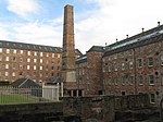 Upload another image | |
| Megginch Castle | Errol | NO2419524605 | 56°24′27″N 3°13′48″W / 56.407576°N 3.230009°W / 56.407576; -3.230009 (Megginch Castle) | 15th-century tower house with later additions, including a wing by Robert Adam[50] | 10963 |  Upload another image | |
| Megginch Castle, Stables | Errol | NO2414224670 | 56°24′29″N 3°13′51″W / 56.408151°N 3.230886°W / 56.408151; -3.230886 (Megginch Castle, Stables) | Early-19th-century Gothic stable courtyard[51] | 10964 | Upload Photo | |
| Megginch Castle, North Lodges | Errol | NO2348124936 | 56°24′38″N 3°14′30″W / 56.410434°N 3.241673°W / 56.410434; -3.241673 (Megginch Castle, North Lodges) | Late-18th-century gatehouse lodges[52] | 10969 | 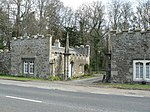 Upload another image | |
| Balthayock House, Bridge over Hail Pool | North-west of Glencarse | NO1779223096 | 56°23′35″N 3°20′00″W / 56.39295°N 3.333264°W / 56.39295; -3.333264 (Balthayock House, Bridge over Hail Pool) | Cast-iron bridge c. 1870, on north-east drive of Balthayock House[53] | 10986 | Upload Photo | |
| Forteviot Square | Forteviot | NO0514817523 | 56°20′26″N 3°32′10″W / 56.340529°N 3.535988°W / 56.340529; -3.535988 (Forteviot Square) | U-plan group of single-storey houses by James Miller, 1925[54] | 11057 |  Upload another image | |
| Forteviot Hall | Forteviot | NO0518317488 | 56°20′25″N 3°32′07″W / 56.340222°N 3.535409°W / 56.340222; -3.535409 (Forteviot Hall) | Village hall by James Miller, 1925[55] | 11058 |  Upload another image | |
| Invermay House | South of Forteviot | NO0606816095 | 56°19′40″N 3°31′14″W / 56.327888°N 3.520601°W / 56.327888; -3.520601 (Invermay House) | Mid 18th-century Georgian house[56] | 11071 | Upload Photo | |
| Old House of Invermay | South of Forteviot | NO0608716206 | 56°19′44″N 3°31′13″W / 56.328888°N 3.520334°W / 56.328888; -3.520334 (Old House of Invermay) | Late-16th-century tower house[57] | 11074 | Upload Photo | |
| Hermitage Bridge | Over River Braan at The Hermitage, Dunkeld | NO0087541753 | 56°33′26″N 3°36′51″W / 56.55725°N 3.614284°W / 56.55725; -3.614284 (Hermitage Bridge) | Rustic stone arch bridge, c. 1785[58] | 11104 |  Upload another image | |
| Dalguise Viaduct | Over River Tay at Dalguise | NN9949747943 | 56°36′45″N 3°38′21″W / 56.612544°N 3.639097°W / 56.612544; -3.639097 (Dalguise Viaduct) | Lattice-girder railway viaduct of 1863, by Joseph Mitchell[59] | 11117 |  Upload another image | |
| Dunkeld & Birnam railway station | Dunkeld and Birnam | NO0308441676 | 56°33′25″N 3°34′42″W / 56.55702°N 3.578332°W / 56.55702; -3.578332 (Dunkeld & Birnam railway station) | Gothic station building of 1856, by Andrew Heiton Jr.[60] | 11139 | 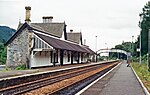 Upload another image | |
| Murthly Castle, Roman Bridge | Over Birnam Burn, Murthly | NO0570339536 | 56°32′18″N 3°32′06″W / 56.538335°N 3.534963°W / 56.538335; -3.534963 (Murthly Castle, Roman Bridge) | Mid 19th-century six-arch bridge in the style of a Roman aqueduct[61] | 11145 | Upload Photo | |
| Murthly Castle | Murthly | NO0705039560 | 56°32′20″N 3°30′47″W / 56.538819°N 3.513077°W / 56.538819; -3.513077 (Murthly Castle) | 16th-century tower house with later additions[62] | 11146 |  Upload another image | |
| Murthly Castle, Walled Garden | Murthly | NO0721439811 | 56°32′28″N 3°30′38″W / 56.541106°N 3.510501°W / 56.541106; -3.510501 (Murthly Castle, Walled Garden) | Walled garden dating to the 17th century[63] | 11147 | Upload Photo
| |
| Kinross House | Kinross | NO1263702044 | 56°12′11″N 3°24′35″W / 56.202946°N 3.40976°W / 56.202946; -3.40976 (Kinross House) | Begun in 1686, by Sir William Bruce[64] | 11200 | 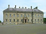 Upload another image | |
| Dalreoch Bridge | Over River Earn north of Dunning | NO0038417896 | 56°20′34″N 3°36′47″W / 56.3429°N 3.613161°W / 56.3429; -3.613161 (Dalreoch Bridge) | 18th-century four-arch bridge[65] | 11211 | Upload Photo | |
| Kinnaird Castle | Kinnaird, Gowrie | NO2412228904 | 56°26′46″N 3°13′57″W / 56.446178°N 3.23244°W / 56.446178; -3.23244 (Kinnaird Castle) | Tower house of c. 1500[66] | 11218 |  Upload another image | |
| Kirk O' The Muir | Murthly | NO1122137044 | 56°31′01″N 3°26′40″W / 56.51703°N 3.444416°W / 56.51703; -3.444416 (Kirk O' The Muir) | Disused United Presbyterian Church[67] | 11233 | Upload Photo | |
| Hilton House | Bridge of Earn | NO1163320067 | 56°21′53″N 3°25′55″W / 56.364633°N 3.431977°W / 56.364633; -3.431977 (Hilton House) | Little-altered house of 1732[68] | 11329 | Upload Photo | |
| Tulliebole Castle | Crook of Devon | NO0526800575 | 56°11′18″N 3°31′41″W / 56.188342°N 3.527967°W / 56.188342; -3.527967 (Tulliebole Castle) | 16th-century tower house[69] | 11459 |  Upload another image | |
| Aldie Castle | Crook of Devon | NT0500597789 | 56°09′48″N 3°31′52″W / 56.163268°N 3.531207°W / 56.163268; -3.531207 (Aldie Castle) | 16th-century tower house[70] | 11469 | 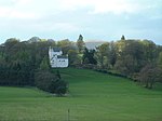 Upload another image | |
| Errol Parish Church | Errol | NO2526922959 | 56°23′35″N 3°12′44″W / 56.392963°N 3.212139°W / 56.392963; -3.212139 (Errol Parish Church) | 18th-century Gothic church by James Gillespie Graham[71] | 11589 | 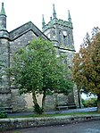 Upload another image | |
| Errol Park House | Errol | NO2476122611 | 56°23′23″N 3°13′13″W / 56.389756°N 3.220266°W / 56.389756; -3.220266 (Errol Park House) | 19th-century Renaissance-style house by Alexander Johnston[72] | 11598 |  Upload another image | |
| Errol Park Stables | Errol | NO2472722659 | 56°23′25″N 3°13′15″W / 56.390182°N 3.22083°W / 56.390182; -3.22083 (Errol Park Stables) | Early-19th-century circular-plan stable courtyard[73] | 11599 | 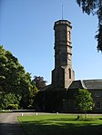 Upload another image | |
| Seasyde House | Errol | NO2836424383 | 56°24′22″N 3°09′45″W / 56.406233°N 3.162406°W / 56.406233; -3.162406 (Seasyde House) | Country house of c. 1800[74] | 11605 | Upload Photo | |
| Fingask Castle sundial | Rait | NO2283327442 | 56°25′58″N 3°15′10″W / 56.432837°N 3.252911°W / 56.432837; -3.252911 (Fingask Castle sundial) | Polyhedral Baroque sundial, possibly 17th-century[75] | 11635 | Upload Photo | |
| Ballindean House | Inchture | NO2685929929 | 56°27′21″N 3°11′18″W / 56.455817°N 3.188341°W / 56.455817; -3.188341 (Ballindean House) | Classical country house of 1832[76] | 11760 |  Upload another image | |
| Rossie Church | Rossie Priory, Longforgan | NO2916130807 | 56°27′51″N 3°09′04″W / 56.464056°N 3.151237°W / 56.464056; -3.151237 (Rossie Church) | Medieval church, rebuilt in the 19th century[77] | 11786 | Upload Photo | |
| Old Rossie Market Cross | Rossie Priory, Longforgan | NO2921130728 | 56°27′48″N 3°09′01″W / 56.463353°N 3.150404°W / 56.463353; -3.150404 (Old Rossie Market Cross) | Mercat cross dated 1746[78] | 11787 | Upload Photo | |
| Grandtully Castle | Grandtully | NN8911751342 | 56°38′27″N 3°48′35″W / 56.640722°N 3.809587°W / 56.640722; -3.809587 (Grandtully Castle) | Late-16th-century Z-plan tower house[79] | 11830 |  Upload another image | |
| Grandtully Chapel | Grandtully | NN8869250638 | 56°38′03″N 3°48′58″W / 56.6343°N 3.816209°W / 56.6343; -3.816209 (Grandtully Chapel) | 16th-century chapel[80] | 11831 |  Upload another image | |
| Logierait Viaduct | Over River Tay at Logierait | NN9686351816 | 56°38′48″N 3°41′01″W / 56.64675°N 3.683541°W / 56.64675; -3.683541 (Logierait Viaduct) | Iron railway viaduct, now used as a road bridge[81] | 11851 |  Upload another image | |
| Kinfauns Castle | East of Perth | NO1504622647 | 56°23′18″N 3°22′39″W / 56.388432°N 3.377586°W / 56.388432; -3.377586 (Kinfauns Castle) | Castellated mansion of 1825, by Sir Robert Smirke[82] | 11955 | 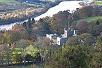 Upload another image | |
| Glendoick House | St Madoes | NO2075023605 | 56°23′53″N 3°17′08″W / 56.398028°N 3.285516°W / 56.398028; -3.285516 (Glendoick House) | Mid 18th-century Georgian house[83] | 11966 | 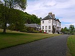 Upload another image | |
| Taymouth Castle Dairy | Kenmore | NN7797845915 | 56°35′21″N 3°59′19″W / 56.589225°N 3.98853°W / 56.589225; -3.98853 (Taymouth Castle Dairy) | Rustic Italianate ornamental building in white quartz[84] | 12091 | 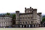 Upload another image | |
| Taymouth Castle | Kenmore | NN7844046523 | 56°35′41″N 3°58′53″W / 56.594804°N 3.981298°W / 56.594804; -3.981298 (Taymouth Castle) | Castellated mansion, mainly 19th-century, including work by Archibald Elliot, William Atkinson and James Gillespie Graham[85] | 12093 | 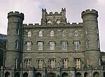 Upload another image | |
| Taymouth Castle, Fort Lodge | Kenmore | NN7902246094 | 56°35′28″N 3°58′18″W / 56.591102°N 3.971625°W / 56.591102; -3.971625 (Taymouth Castle, Fort Lodge) | Rustic cottage of late 1830s[86] | 12096 | Upload Photo | |
| Taymouth Castle, Chinese Bridge | Kenmore | NN7824346734 | 56°35′48″N 3°59′05″W / 56.596647°N 3.984603°W / 56.596647; -3.984603 (Taymouth Castle, Chinese Bridge) | Early-19th-century cast-iron three-arch bridge[87] | 12097 | 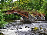 Upload another image | |
| Taymouth Castle, Rustic Lodge | Kenmore | NN7893347870 | 56°36′25″N 3°58′26″W / 56.607025°N 3.973905°W / 56.607025; -3.973905 (Taymouth Castle, Rustic Lodge) | Rustic cottage of c. 1840[88] | 12100 | Upload Photo | |
| Kenmore Bridge | Over River Tay at Kenmore | NN7715045554 | 56°35′09″N 4°00′07″W / 56.585767°N 4.001831°W / 56.585767; -4.001831 (Kenmore Bridge) | Seven-arch stone bridge, c. 1774, by John Baxter, possibly working with John Smeaton[89] | 12138 |  Upload another image | |
| Connachan Lodge | North of Crieff | NN8958527582 | 56°25′39″N 3°47′31″W / 56.427481°N 3.791854°W / 56.427481; -3.791854 (Connachan Lodge) | Early-19th-century Cottage ornée[90] | 12213 | Upload Photo | |
| Abercairny sundial | Crieff | NN9111122393 | 56°22′52″N 3°45′54″W / 56.381239°N 3.764967°W / 56.381239; -3.764967 (Abercairny sundial) | 17th-century lectern sundial[91] | 12257 | Upload Photo | |
| All Souls Episcopal Church | Invergowrie Main Street | NO3460330359 | 56°27′39″N 3°03′46″W / 56.460819°N 3.062825°W / 56.460819; -3.062825 (All Souls Episcopal Church) | Late-19th-century Gothic church by Hippolyte Blanc[92] | 12849 |  Upload another image | |
| HMP Castle Huntly | Longforgan | NO3019429105 | 56°26′56″N 3°08′02″W / 56.448922°N 3.134021°W / 56.448922; -3.134021 (HMP Castle Huntly) | Mid 15th-century tower house with 18th-century wings, now an open prison[93] | 12868 | Upload Photo | |
| Castle Huntly, North Gates | Longforgan | NO3043629580 | 56°27′12″N 3°07′49″W / 56.453224°N 3.130222°W / 56.453224; -3.130222 (Castle Huntly, North Gates) | Late-17th-century Renaissance-style gateway[94] | 12871 |  Upload another image | |
| Longforgan Market Cross | Longforgan Main Street | NO3107630010 | 56°27′26″N 3°07′12″W / 56.457181°N 3.119955°W / 56.457181; -3.119955 (Longforgan Market Cross) | Later 17th-century mercat cross[95] | 13283 | 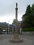 Upload another image | |
| Chapel of St Anthony The Eremite | Murthly | NO0713440061 | 56°32′36″N 3°30′43″W / 56.543335°N 3.511891°W / 56.543335; -3.511891 (Chapel of St Anthony The Eremite) | Pre-reformation mortuary chapel, extended by James Gillespie Graham and A W N Pugin in 1846[96] | 13460 |  Upload another image | |
| Marlee House (formerly Kinloch House) | Kinloch, Blairgowrie | NO1489544505 | 56°35′05″N 3°23′14″W / 56.584719°N 3.387177°W / 56.584719; -3.387177 (Marlee House (formerly Kinloch House)) | 17th-century house, remodelled c. 1746[97] | 13742 |  Upload another image | |
| Inchmartine House | Inchture | NO2624128076 | 56°26′21″N 3°11′52″W / 56.439077°N 3.197841°W / 56.439077; -3.197841 (Inchmartine House) | House of c. 1800, incorporating earlier fabric[98] | 13773 |  Upload another image | |
| Taymouth Castle, Maxwell's Temple | Kenmore | NN7756145974 | 56°35′23″N 3°59′43″W / 56.589646°N 3.995343°W / 56.589646; -3.995343 (Taymouth Castle, Maxwell's Temple) | Monument of 1831 by William Atkinson[99] | 13804 | Upload Photo | |
| Meggernie Castle | Glenlyon | NN5538246033 | 56°35′02″N 4°21′22″W / 56.58386°N 4.356209°W / 56.58386; -4.356209 (Meggernie Castle) | 17th-century tower house[100] | 13812 |  Upload another image | |
| Inchyra House | St Madoes | NO1903621311 | 56°22′38″N 3°18′45″W / 56.377133°N 3.312567°W / 56.377133; -3.312567 (Inchyra House) | Classical country house of c. 1800[101] | 17624 |  Upload another image | |
| Pitfour Castle | St Madoes | NO1994820880 | 56°22′24″N 3°17′52″W / 56.373417°N 3.297672°W / 56.373417; -3.297672 (Pitfour Castle) | Castellated house of 1784 by Robert Adam[102] | 17628 | 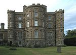 Upload another image | |
| Elcho Castle, Dovecot | Rhynd | NO1632720918 | 56°22′23″N 3°21′23″W / 56.373131°N 3.356292°W / 56.373131; -3.356292 (Elcho Castle, Dovecot) | Late-16th-century circular dovecote[103] | 17714 |  Upload another image | |
| Telephone Call Box | Rhynd | NO1581520055 | 56°21′55″N 3°21′51″W / 56.365289°N 3.364302°W / 56.365289; -3.364302 (Telephone Call Box) | "K3" telephone box, the only one surviving in its original location[104] | 17718 |  Upload another image | |
| Colquhalzie House | East of Muthill | NN9137317466 | 56°20′13″N 3°45′31″W / 56.337055°N 3.758687°W / 56.337055; -3.758687 (Colquhalzie House) | 18th-century country house[105] | 17771 | Upload Photo | |
| Weem Old Parish Kirk | Weem | NN8429649797 | 56°37′32″N 3°53′15″W / 56.625683°N 3.887455°W / 56.625683; -3.887455 (Weem Old Parish Kirk) | 17th-century former church, including the funerary monuments of the Menzies family[106] | 17815 |  Upload another image | |
| Williamston House | South-west of Methven | NN9722322056 | 56°22′46″N 3°39′57″W / 56.379582°N 3.665904°W / 56.379582; -3.665904 (Williamston House) | Early-17th-century country house[107] | 17836 | Upload Photo | |
| Glenalmond College Main Building | Glenalmond | NN9775328984 | 56°26′31″N 3°39′36″W / 56.441913°N 3.660034°W / 56.441913; -3.660034 (Glenalmond College Main Building) | Gothic revival college building, begun in 1846 with later additions[108] | 17869 |  Upload another image | |
| Methven Castle | Methven | NO0416626040 | 56°25′01″N 3°33′18″W / 56.416821°N 3.554981°W / 56.416821; -3.554981 (Methven Castle) | Country house of 1664 by John Mylne[109] | 17895 | 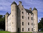 Upload another image | |
| Dalcrue House | Methven | NO0430327922 | 56°26′02″N 3°33′12″W / 56.43375°N 3.55345°W / 56.43375; -3.55345 (Dalcrue House) | Italianate house of 1832 by William Henry Playfair[110] | 17897 | Upload Photo | |
| Dry Bridge | Methven | NO0532328346 | 56°26′16″N 3°32′13″W / 56.437764°N 3.53707°W / 56.437764; -3.53707 (Dry Bridge) | Part of Lynedoch estate drive, designed by William Henry Playfair in 1832[111] | 17921 |  Upload another image | |
| Methven Aisle, Methven Parish Church | Methven | NO0256826045 | 56°25′00″N 3°34′51″W / 56.416538°N 3.580874°W / 56.416538; -3.580874 (Methven Aisle, Methven Parish Church) | 15th-century transept of former collegiate church[112] | 17928 | Upload Photo | |
| Lochlane House | Crieff | NN8341921358 | 56°22′12″N 3°53′20″W / 56.37011°N 3.888999°W / 56.37011; -3.888999 (Lochlane House) | Small mansion of 1710[113] | 18149 | Upload Photo | |
| Lawers House | Comrie | NN7992023029 | 56°23′03″N 3°56′47″W / 56.384238°N 3.946375°W / 56.384238; -3.946375 (Lawers House) | Country house of 1738 by William Adam[114] | 18152 |  Upload another image | |
| Ochtertyre House | Ochtertyre | NN8387523626 | 56°23′26″N 3°52′57″W / 56.390588°N 3.882625°W / 56.390588; -3.882625 (Ochtertyre House) | Georgian country house of 1790[115] | 18170 |  Upload another image | |
| Belmont Castle | Meigle | NO2861443926 | 56°34′55″N 3°09′49″W / 56.581809°N 3.16372°W / 56.581809; -3.16372 (Belmont Castle) | 15th-century tower extended in the 18th century, 19th-century alterations[116] | 18332 | Upload Photo | |
| Scone Palace | Scone | NO1138726527 | 56°25′21″N 3°26′17″W / 56.422606°N 3.438143°W / 56.422606; -3.438143 (Scone Palace) | Early-19th-century rebuilding of earlier house, by William Atkinson[117] | 18370 |  Upload another image | |
| Scone Palace Mortuary Chapel or Mausoleum | Scone Palace | NO1141826636 | 56°25′25″N 3°26′16″W / 56.423591°N 3.437678°W / 56.423591; -3.437678 (Scone Palace Mortuary Chapel or Mausoleum) | Remodelling of earlier church aisle by William Atkinson, monument to Viscount Stormont inside[118] | 18371 | 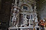 Upload another image | |
| Cottown School House | Cottown | NO2057521023 | 56°22′29″N 3°17′15″W / 56.374807°N 3.287567°W / 56.374807; -3.287567 (Cottown School House) | 18th-century thatched building, formerly a school[119] | 19809 | Upload Photo | |
| Haugh of Drimmie Suspension Bridge | Over River Ericht at Glenericht Lodge Drive | NO1700050214 | 56°38′11″N 3°21′17″W / 56.63637°N 3.354752°W / 56.63637; -3.354752 (Haugh of Drimmie Suspension Bridge) | Wrought iron bridge built before 1837[120] | 19830 | Upload Photo | |
| Old Scone Market Cross | Scone Palace | NO1158026652 | 56°25′26″N 3°26′06″W / 56.423765°N 3.435058°W / 56.423765; -3.435058 (Old Scone Market Cross) | Medieval town cross[121] | 19876 | 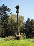 Upload another image | |
| Drummond Castle Formal Garden | Muthill | NN8444917930 | 56°20′22″N 3°52′15″W / 56.339582°N 3.870825°W / 56.339582; -3.870825 (Drummond Castle Formal Garden) | Walled gardens laid out in 1832, with pavilions and 17th-century sundial[122] | 19883 | 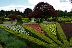 Upload another image | |
| Aberfeldy Water Mill | Aberfeldy | NN8551949067 | 56°37′10″N 3°52′02″W / 56.619429°N 3.86721°W / 56.619429; -3.86721 (Aberfeldy Water Mill) | 19th-century water mill, restored in 1988[123] | 20859 |  Upload another image | |
| Tay Bridge | Aberfeldy | NN8513449298 | 56°37′17″N 3°52′25″W / 56.621409°N 3.873583°W / 56.621409; -3.873583 (Tay Bridge) | Classically detailed bridge, designed by William Adam and built by General Wade in 1733[124] | 20861 | 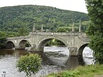 Upload another image | |
| Newton Castle | Blairgowrie | NO1716945273 | 56°35′31″N 3°21′01″W / 56.592024°N 3.350413°W / 56.592024; -3.350413 (Newton Castle) | Mid 16th-century Z-plan tower house with later additions[125] | 22314 | 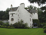 Upload another image | |
| War Memorial | Wellmeadow, Blairgowrie | NO1799145220 | 56°35′30″N 3°20′13″W / 56.591692°N 3.337015°W / 56.591692; -3.337015 (War Memorial) | World War I memorial, designed by Reginald Fairlie and sculpted by Alexander Carrick[126] | 22321 | 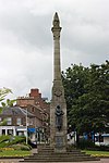 Upload another image | |
| Keathbank Mill | Rattray | NO1777646153 | 56°36′00″N 3°20′27″W / 56.600034°N 3.340812°W / 56.600034; -3.340812 (Keathbank Mill) | 19th-century textile mill[127] | 22332 |  Upload another image | |
| Inchglas | Crieff | NN8653021277 | 56°22′13″N 3°50′19″W / 56.37014°N 3.838627°W / 56.37014; -3.838627 (Inchglas) | Gothic villa of 1854 by Frederick Thomas Pilkington[128] | 23488 | Upload Photo | |
| The Avanti Restaurant (former British Linen Bank) | Crieff, 32-34, Crieff High Street | NN8649021578 | 56°22′22″N 3°50′22″W / 56.372833°N 3.839405°W / 56.372833; -3.839405 (The Avanti Restaurant (former British Linen Bank)) | Offices of 1900 by George Washington Browne[129] | 23489 | 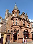 Upload another image | |
| South United Free Church | Crieff | NN8625721782 | 56°22′29″N 3°50′36″W / 56.374609°N 3.843263°W / 56.374609; -3.843263 (South United Free Church) | Later 19th-century Scots Gothic church by J. J. Stevenson[130] | 23509 | 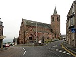 Upload another image | |
| St John's Kirk | Perth | NO1194223546 | 56°23′45″N 3°25′41″W / 56.395937°N 3.428146°W / 56.395937; -3.428146 (St John's Kirk) | 15th-century church[131] | 39300 |  Upload another image | |
| St Leonard's-in-the-Fields Church | Perth | NO1162723166 | 56°23′33″N 3°25′59″W / 56.392465°N 3.433119°W / 56.392465; -3.433119 (St Leonard's-in-the-Fields Church) | Scots Gothic church of 1885 by J. J. Stevenson[132] | 39310 |  Upload another image | |
| St Ninian's Cathedral | Perth | NO1147123915 | 56°23′57″N 3°26′09″W / 56.399163°N 3.435898°W / 56.399163; -3.435898 (St Ninian's Cathedral) | Mid 19th-century Episcopal cathedral by William Butterfield[133] | 39314 |  Upload another image | |
| King James VI Hospital | Perth | NO1151023427 | 56°23′41″N 3°26′06″W / 56.394788°N 3.435101°W / 56.394788; -3.435101 (King James VI Hospital) | Former infirmary and school built 1750, one of the finest 18th-century examples of its type in Scotland[134] | 39319 |  Upload another image | |
| Old Perth Academy | Perth | NO1167824027 | 56°24′01″N 3°25′57″W / 56.400208°N 3.432583°W / 56.400208; -3.432583 (Old Perth Academy) | Former school built 1804, by Robert Reid[135] | 39322 |  Upload another image | |
| York Place, A K Bell Library including Boundary Wall to York Place | Perth | NO1135423454 | 56°23′42″N 3°26′15″W / 56.395001°N 3.437637°W / 56.395001; -3.437637 (York Place, A K Bell Library including Boundary Wall to York Place) | Neo-classical infirmary by W M Mackenzie, built 1836 and later converted to offices[136] | 39323 |  Upload another image | |
| Perth Sheriff Court | Perth | NO1206223391 | 56°23′40″N 3°25′34″W / 56.394567°N 3.42615°W / 56.394567; -3.42615 (Perth Sheriff Court) | Greek Revival court house by Robert Smirke, 1819[137] | 39325 |  Upload another image | |
| Perth Prison, Main Block | Perth | NO1178622395 | 56°23′08″N 3°25′49″W / 56.38557°N 3.430284°W / 56.38557; -3.430284 (Perth Prison, Main Block) | Central building of 1812 by Robert Reid, radial buildings added in the 1840s and 1850s by Thomas Brown and Robert Matheson [138] | 39331 |  Upload another image | |
| Perth Bridge | Over River Tay at Perth | NO1211823883 | 56°23′56″N 3°25′31″W / 56.398997°N 3.425408°W / 56.398997; -3.425408 (Perth Bridge) | Seven-arch bridge by John Smeaton, completed 1771[139] | 39339 |  Upload another image | |
| Perth Water Works | Perth | NO1203823137 | 56°23′32″N 3°25′35″W / 56.392282°N 3.426454°W / 56.392282; -3.426454 (Perth Water Works) | Neo-Classical former waterworks, 1832 by Adam Anderson, one of Scotland's most significant industrial buildings, now an art gallery[140] | 39341 |  Upload another image | |
| Pitheavlis Castle | Perth | NO1051822805 | 56°23′20″N 3°27′03″W / 56.389014°N 3.450953°W / 56.389014; -3.450953 (Pitheavlis Castle) | Late-16th-century L-plan tower house[141] | 39346 |  Upload another image | |
| 2–8 Atholl Crescent | Perth | NO1175323910 | 56°23′57″N 3°25′53″W / 56.399171°N 3.431329°W / 56.399171; -3.431329 (2–8 Atholl Crescent) | Crescent of houses, begun in 1797[142] | 39354 |  Upload another image | |
| 2–4 Charlotte Place and 20 Charlotte Street | Perth | NO1190723846 | 56°23′55″N 3°25′44″W / 56.398625°N 3.428813°W / 56.398625; -3.428813 (2–4 Charlotte Place and 20 Charlotte Street) | Neo-Greek houses of circa 1830[143] | 39392 | 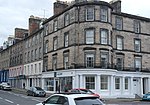 Upload another image | |
| Barnhill Tollhouse | Perth, Dundee Road | NO1247022754 | 56°23′20″N 3°25′10″W / 56.388922°N 3.41933°W / 56.388922; -3.41933 (Barnhill Tollhouse) | Early-19th-century toll house[144] | 39422 |  Upload another image | |
| Upper City Mills (now City Mills Hotel) | Perth | NO1141723731 | 56°23′51″N 3°26′12″W / 56.3975°N 3.43671°W / 56.3975; -3.43671 (Upper City Mills (now City Mills Hotel)) | 18th-century water mill[145] | 39577 | Upload Photo | |
| Lower City Mills | Perth | NO1148523722 | 56°23′51″N 3°26′08″W / 56.397432°N 3.435606°W / 56.397432; -3.435606 (Lower City Mills) | Early-19th-century water mill[146] | 39578 | 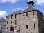 Upload another image | |
| Bank of Scotland | St John Street, Perth | NO1200223519 | 56°23′45″N 3°25′38″W / 56.395706°N 3.427165°W / 56.395706; -3.427165 (Bank of Scotland) | Italian Renaissance bank offices of 1846 by David Rhind[147] | 39618 |  Upload another image | |
| Pitlochry Parish Church | Pitlochry | NN9400558286 | 56°42′15″N 3°43′58″W / 56.704209°N 3.73279°W / 56.704209; -3.73279 (Pitlochry Parish Church) | Romanesque church of 1884 by Charles & Leslie Ower[148] | 39850 | 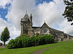 Upload another image | |
| Sunnybrae Cottage | Pitlochry | NN9364658315 | 56°42′16″N 3°44′19″W / 56.704388°N 3.738663°W / 56.704388; -3.738663 (Sunnybrae Cottage) | Cruck-framed vernacular cottage of late 18th or early 19th century[149] | 39866 |  Upload another image | |
| Pitlochry railway station | Pitlochry | NN9382458103 | 56°42′09″N 3°44′08″W / 56.702525°N 3.735669°W / 56.702525; -3.735669 (Pitlochry railway station) | Station buildings built 1890[150] | 39867 |  Upload another image | |
| Castle Menzies | Weem | NN8370149613 | 56°37′26″N 3°53′49″W / 56.623883°N 3.897064°W / 56.623883; -3.897064 (Castle Menzies) | 16th-century Z-plan tower house[151] | 43568 | 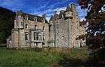 Upload another image | |
| Stobhall, Folly | North-east of Stanley | NO1324734511 | 56°29′41″N 3°24′38″W / 56.494659°N 3.410657°W / 56.494659; -3.410657 (Stobhall, Folly) | Summer house built in 1989 to incorporate earlier 18th-century panelling[152] | 43856 | Upload Photo | |
| Pitlochry Power Station, dam and fish ladder | Loch Faskally, Pitlochry | NN9354257719 | 56°41′56″N 3°44′24″W / 56.699013°N 3.740113°W / 56.699013; -3.740113 (Pitlochry Power Station, dam and fish ladder) | Mid 20th-century hydro-electric power station[153] | 47534 |  Upload another image | |
| Clunie Power Station | Loch Faskally | NN9126759775 | 56°43′01″N 3°46′41″W / 56.71695°N 3.778116°W / 56.71695; -3.778116 (Clunie Power Station) | Mid 20th-century hydro-electric power station[154] | 47621 | 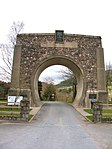 Upload another image | |
| Cultybraggan Former Cadet Camp, Huts 19 and 20 (Guard's Block) and 44, 45, 46 | Comrie | NN7687719948 | 56°21′21″N 3°59′39″W / 56.355792°N 3.994179°W / 56.355792; -3.994179 (Cultybraggan Former Cadet Camp, Huts 19 and 20 (Guard's Block) and 44, 45, 46) | Purpose-built World War II Prisoner of War camp, one of the best-preserved in Britain[155] | 50471 | 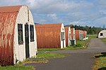 Upload another image |
See also
Notes
- ^ Sometimes known as OSGB36, the grid reference (where provided) is based on the British national grid reference system used by the Ordnance Survey.
• "Guide to National Grid". Ordnance Survey. Retrieved 12 December 2007.
• "Get-a-map". Ordnance Survey. Retrieved 17 December 2007. - ^ Historic Environment Scotland assign a unique alphanumeric identifier to each designated site in Scotland, for listed buildings this always begins with "LB", for example "LB12345".
References
- ^ Guide to the Protection of Scotland’s Listed Buildings (PDF). Historic Scotland. 2009. p. 4. ISBN 978-1-84917-013-0. Retrieved 5 May 2010.
- ^ "What is Listing?". Historic Scotland. Retrieved 5 May 2010.
- ^ a b Scottish Historic Environment Policy (PDF). Historic Scotland. October 2008. pp. 24–25. ISBN 978-1-84917-002-4. Retrieved 5 May 2010.
- ^ Guide to the Protection of Scotland’s Listed Buildings, p. 17.
- ^ "Category A Listed Buildings in Perth and Kinross". British Listed Buildings. Retrieved 7 July 2020.
- ^ "Bridge Of Ruim Over Quiech Burn (Variously Spelt Also Rome Or Room: Listed Building Report". Historic Scotland.
- ^ "Old Fincastle House: Listed Building Report". Historic Scotland.
- ^ "Stobhall Sundial No. 2 Approx 35 Yards North Of Caretakers House And Garages: Listed Building Report". Historic Scotland.
- ^ "Drummonie House: Listed Building Report". Historic Scotland.
- ^ "Balhary House: Listed Building Report". Historic Scotland.
- ^ "Bridge Of Isla, Near Meikleour, Over R. Isla: Listed Building Report". Historic Scotland.
- ^ "Gourdie House: Listed Building Report". Historic Scotland.
- ^ "Meikleour Cross, Meikleour: Listed Building Report". Historic Scotland.
- ^ "Bell Mill, Or West Mill, Stanley Mills Including Iron Gangway, Belt Proofing Machine And West Sluice Chamber: Listed Building Report". Historic Scotland.
- ^ "Mid Mill, Stanley Mills, Including Cotton Machinery: Listed Building Report". Historic Scotland.
- ^ "Kilgraston House: Listed Building Report". Historic Scotland.
- ^ "Aberuchill (Original Tower House And Wing To East Only): Listed Building Report". Historic Scotland.
- ^ "Old Parish Church, (Now Comrie Youth Centre Flambeaux Club) Dunira St.: Listed Building Report". Historic Scotland.
- ^ "Property Occupied By Brough & Mcpherson, Mitchell & Thomson, And Smith, Also Miss Findlay, Dunira St.: Listed Building Report". Historic Scotland.
- ^ "Balmanno Castle Including Garden House Outbuilding And Gatehouse.: Listed Building Report". Historic Scotland.
- ^ "Ecclesmagirdle (Or Ecclesiamagirdle) House: Listed Building Report". Historic Scotland.
- ^ "Ecclesmagirdle, Doocot: Listed Building Report". Historic Scotland.
- ^ "Balvaird Castle: Listed Building Report". Historic Scotland.
- ^ "Stobhall, Chapel Block: Listed Building Report". Historic Scotland.
- ^ "Stobhall, Laundry, Brewhouse And Bakehouse Block: Listed Building Report". Historic Scotland.
- ^ "Stobhall, Dowery House: Listed Building Report". Historic Scotland.
- ^ "Stobhall New Library Barnet Road: Listed Building Report". Historic Scotland.
- ^ "Stobhall, Sundial No. 1. Approx 25 Yards North Of Dowery House: Listed Building Report". Historic Scotland.
- ^ "Dunkeld Bridge Over River Tay.: Listed Building Report". Historic Scotland.
- ^ "Dunkeld Cathedral: Listed Building Report". Historic Scotland.
- ^ "Blackcraig Bridge Over R. Ericht: Listed Building Report". Historic Scotland.
- ^ "Ardblair Castle Including Sundials And Garden Statuary: Listed Building Report". Historic Scotland.
- ^ "Cleish Castle: Listed Building Report". Historic Scotland.
- ^ "Blair Adam House: Listed Building Report". Historic Scotland.
- ^ "Tummel Bridge.: Listed Building Report". Historic Scotland.
- ^ "Monzie Castle: Listed Building Report". Historic Scotland.
- ^ "Innerpeffray Library: Listed Building Report". Historic Scotland.
- ^ "Montrose Mausoleum St. Kattan's Churchyard Aberuthven: Listed Building Report". Historic Scotland.
- ^ "Clunie Castle: Listed Building Report". Historic Scotland.
- ^ "Keltie Castle.: Listed Building Report". Historic Scotland.
- ^ "Duncrub Dovecot: Listed Building Report". Historic Scotland.
- ^ "Parish Church Of St. Serf.: Listed Building Report". Historic Scotland.
- ^ "Auchleeks House: Listed Building Report". Historic Scotland.
- ^ "Front Lodge, Blair Castle: Listed Building Report". Historic Scotland.
- ^ "Grotto On River Tilt Opposite York Cascade: Listed Building Report". Historic Scotland.
- ^ "Blair Castle: Listed Building Report". Historic Scotland.
- ^ "Sundial: Listed Building Report". Historic Scotland.
- ^ "Keithick House: Listed Building Report". Historic Scotland.
- ^ "East Mill, Stanley Mills, With Mill Pond And Sluice: Listed Building Report". Historic Scotland.
- ^ "Megginch Castle And Garden Structures: Listed Building Report". Historic Scotland.
- ^ "Megginch Castle, Stables, Dovecot, Screen Walls And Gatepiers: Listed Building Report". Historic Scotland.
- ^ "Megginch Castle, North Lodges And Gatepiers: Listed Building Report". Historic Scotland.
- ^ "Balthayock House, Bridge Over Hail Pool: Listed Building Report". Historic Scotland.
- ^ "Forteviot Square.: Listed Building Report". Historic Scotland.
- ^ "Forteviot Hall.: Listed Building Report". Historic Scotland.
- ^ "Invermay House: Listed Building Report". Historic Scotland.
- ^ "Old House Of Invermay: Listed Building Report". Historic Scotland.
- ^ "Hermitage Bridge Over R. Braan: Listed Building Report". Historic Scotland.
- ^ "Dalguise Railway Viaduct Over R. Tay: Listed Building Report". Historic Scotland.
- ^ "Dunkeld And Birnam Station: Listed Building Report". Historic Scotland.
- ^ "Roman Bridge, Over Birnam Burn: Listed Building Report". Historic Scotland.
- ^ "Murthly Castle: Listed Building Report". Historic Scotland.
- ^ "Walled Garden, Garden House, Gatepiers On E., Steps, Urns, Etc. On East Of Castle: Listed Building Report". Historic Scotland.
- ^ "Kinross House: Listed Building Report". Historic Scotland.
- ^ "Dalreoch Bridge Over River Earn.: Listed Building Report". Historic Scotland.
- ^ "Kinnaird Castle: Listed Building Report". Historic Scotland.
- ^ "Kirk O' The Muir: Listed Building Report". Historic Scotland.
- ^ "Hilton House: Listed Building Report". Historic Scotland.
- ^ "Tulliebole Castle: Listed Building Report". Historic Scotland.
- ^ "Aldie Castle: Listed Building Report". Historic Scotland.
- ^ "Errol Village, North Bank Dykes, Errol (Church Of Scotland) Parish Church Including Boundary Walls And Gatepiers: Listed Building Report". Historic Scotland.
- ^ "Errol Park House: Listed Building Report". Historic Scotland.
- ^ "Errol Park Stables: Listed Building Report". Historic Scotland.
- ^ "Seasyde House: Listed Building Report". Historic Scotland.
- ^ "Fingask Castle, Sundial: Listed Building Report". Historic Scotland.
- ^ "Ballindean House: Listed Building Report". Historic Scotland.
- ^ "Rossie Church Within Rossie Priory Policies: Listed Building Report". Historic Scotland.
- ^ "Market Cross, Old Rossie Within Rossie Priory Policies: Listed Building Report". Historic Scotland.
- ^ "Grandtully Castle: Listed Building Report". Historic Scotland.
- ^ "Grantully Chapel (Including Adjoining Walls, Gates, Etc.): Listed Building Report". Historic Scotland.
- ^ "Logierait Railway Viaduct Over R. Tay: Listed Building Report". Historic Scotland.
- ^ "Kinfauns Castle: Listed Building Report". Historic Scotland.
- ^ "Glendoick House: Listed Building Report". Historic Scotland.
- ^ "Taymouth Dairy And Terrace On West: Listed Building Report". Historic Scotland.
- ^ "Taymouth Castle: Listed Building Report". Historic Scotland.
- ^ "Fort Lodge: Listed Building Report". Historic Scotland.
- ^ "Chinese Bridge: Listed Building Report". Historic Scotland.
- ^ "Rustic Lodge: Listed Building Report". Historic Scotland.
- ^ "Kenmore Bridge Over River Tay: Listed Building Report". Historic Scotland.
- ^ "Connachan Lodge: Listed Building Report". Historic Scotland.
- ^ "Abercairny Sundial: Listed Building Report". Historic Scotland.
- ^ "Invergowrie, Main Street, All Souls' Episcopal Church, Including Gatepiers And Boundary Walls: Listed Building Report". Historic Scotland.
- ^ "Castle Huntly, Including Terraced Garden And Statuary, And Boundary Walls: Listed Building Report". Historic Scotland.
- ^ "Castle Huntly, North Gates: Listed Building Report". Historic Scotland.
- ^ "Longforgan, Main Street, Market Cross: Listed Building Report". Historic Scotland.
- ^ "Chapel Of St Anthony The Eremite, Murthly: Listed Building Report". Historic Scotland.
- ^ "Marlee House (Originally Kinloch House): Listed Building Report". Historic Scotland.
- ^ "Inchmartine House: Listed Building Report". Historic Scotland.
- ^ "'Maxwell's Temple', Or 'The Cross'.: Listed Building Report". Historic Scotland.
- ^ "Meggernie Castle: Listed Building Report". Historic Scotland.
- ^ "Inchyra House With Court Of Offices At Rear: Listed Building Report". Historic Scotland.
- ^ "Pitfour Castle: Listed Building Report". Historic Scotland.
- ^ "Elcho Castle, Doo'cot: Listed Building Report". Historic Scotland.
- ^ "Rhynd Village, K3 Telephone Kiosk: Listed Building Report". Historic Scotland.
- ^ "Colquhalzie House: Listed Building Report". Historic Scotland.
- ^ "Weem Old Parish Kirk (Menzies Mausoleum): Listed Building Report". Historic Scotland.
- ^ "Williamston House: Listed Building Report". Historic Scotland.
- ^ "Trinity College, Glenalmond Main Building: Listed Building Report". Historic Scotland.
- ^ "Methven Castle: Listed Building Report". Historic Scotland.
- ^ "Dalcrue House: Listed Building Report". Historic Scotland.
- ^ "Dry Bridge: Listed Building Report". Historic Scotland.
- ^ "Methven Aisle Methven Parish Church Graveyard: Listed Building Report". Historic Scotland.
- ^ "Lochlane House: Listed Building Report". Historic Scotland.
- ^ "Lawers House (Now School Of Agriculture): Listed Building Report". Historic Scotland.
- ^ "Ochtertyre House: Listed Building Report". Historic Scotland.
- ^ "Belmont Castle: Listed Building Report". Historic Scotland.
- ^ "Scone Palace Including Terraces.: Listed Building Report". Historic Scotland.
- ^ "Scone Palace Mortuary Chapel or Mausoleum: Listed Building Report". Historic Scotland.
- ^ "Cottown, Former School And Schoolhouse: Listed Building Report". Historic Scotland.
- ^ "Haugh Of Drimmie Suspension Bridge Over River Ericht, Glenericht Lodge Drive: Listed Building Report". Historic Scotland.
- ^ "Scone Palace, Cross Of Old Scone.: Listed Building Report". Historic Scotland.
- ^ "Drummond Castle, Formal Garden: Listed Building Report". Historic Scotland.
- ^ "Mill Street, Aberfeldy Water Mill: Listed Building Report". Historic Scotland.
- ^ "Tay Bridge: Listed Building Report". Historic Scotland.
- ^ "Newton Street, Newton Castle: Listed Building Report". Historic Scotland.
- ^ "Wellmeadow Gardens, War Memorial: Listed Building Report". Historic Scotland.
- ^ "Rattray (New), Balmoral Road, Keathbank Mill: Listed Building Report". Historic Scotland.
- ^ "Broich Terrace, Inchglas Including Boundary Walls And Gatepiers: Listed Building Report". Historic Scotland.
- ^ "High Street, The Bank Restaurant, Former British Linen Bank: Listed Building Report". Historic Scotland.
- ^ "Comrie Street, Old South Church, Antique Galleries Including Mission Hall, Boundary Walls, Railings, Gatepiers And Gates: Listed Building Report". Historic Scotland.
- ^ "St John's Kirk, Kirkside, St John's Place, St John Street: Listed Building Report". Historic Scotland.
- ^ "St Leonard's-In-The Fields Church And Halls, Marshall Place: Listed Building Report". Historic Scotland.
- ^ "St Ninian's Cathedral (Episcopal) Atholl Street And North Methven Street: Listed Building Report". Historic Scotland.
- ^ "King James Vi Hospital, Hospital Street, Albert Place, King Street. (Converted Into Flats): Listed Building Report". Historic Scotland.
- ^ "The Old Academy, 6, 7 Rose Terrace: Listed Building Report". Historic Scotland.
- ^ "Perth And Kinross District Council Offices York Place (Centre Block Only): Listed Building Report". Historic Scotland.
- ^ "Sheriff Court, Tay Street: Listed Building Report". Historic Scotland.
- ^ "Main Prison Block: Listed Building Report". Historic Scotland.
- ^ "Perth Bridge Over River Tay: Listed Building Report". Historic Scotland.
- ^ "Perth Water Works (Now Tourist Information Centre) Tay Street.: Listed Building Report". Historic Scotland.
- ^ "Pitheavlis Castle, 50 Needless Road: Listed Building Report". Historic Scotland.
- ^ "Atholl Crescent, 2-8 (All Numbers): Listed Building Report". Historic Scotland.
- ^ "Charlotte Place 2-4, And 20 Charlotte Street: Listed Building Report". Historic Scotland.
- ^ "Dundee Road Barnhill Tollhouse: Listed Building Report". Historic Scotland.
- ^ "Mill Street, Upper City Mills Now City Mills Hotel: Listed Building Report". Historic Scotland.
- ^ "Mill Street, Lower City Mills: Listed Building Report". Historic Scotland.
- ^ "St John Street, (E. Side) 48, 50, Bank Of Scotland Formerly Central Bank Buildings.: Listed Building Report". Historic Scotland.
- ^ "Church Road, Pitlochry Parish Church, Including Celtic Cross Memorial: Listed Building Report". Historic Scotland.
- ^ "156 Atholl Road, Sunnybrae Cottage: Listed Building Report". Historic Scotland.
- ^ "Station Road, Pitlochry Station, Including Down Platform Building, Footbridge, Fountain And Signal Box: Listed Building Report". Historic Scotland.
- ^ "Castle Menzies: Listed Building Report". Historic Scotland.
- ^ "Stobhall, Summer House: Listed Building Report". Historic Scotland.
- ^ "Pitlochry Power Station And Dam Including Fish Ladder And Drum Gates: Listed Building Report". Historic Scotland.
- ^ "Clunie Power Station Including Memorial Arch, Scottish And Southern Energy Plc: Listed Building Report". Historic Scotland.
- ^ "Comrie, Cultybraggan Former Cadet Camp, Huts 19 And 20 (Guard's Block) and 44, 45, 46: Listed Building Report". Historic Scotland.
External links
![]() Media related to Category A listed buildings in Perth and Kinross at Wikimedia Commons
Media related to Category A listed buildings in Perth and Kinross at Wikimedia Commons
- v
- t
- e
- City of Aberdeen
- Aberdeenshire
- Angus
- Argyll and Bute
- Clackmannanshire
- Dumfries and Galloway
- City of Dundee
- East Ayrshire
- East Dunbartonshire
- East Lothian
- East Renfrewshire
- City of Edinburgh
- Falkirk
- Fife
- City of Glasgow
- Highland
- Inverclyde
- Midlothian
- Moray
- North Ayrshire
- North Lanarkshire
- Orkney
- Perth and Kinross
- Renfrewshire
- Scottish Borders
- Shetland
- South Ayrshire
- South Lanarkshire
- Stirling
- West Dunbartonshire
- West Lothian
- Western Isles (na h-Eileanan Siar)


