La Palma, Los Santos
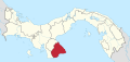
Corregimiento in Los Santos, Panama
7°32′00″N 80°20′00″W / 7.5333°N 80.3333°W / 7.5333; -80.3333 Panama
[1]
(2010)[1]
La Palma is a corregimiento in Las Tablas District, Los Santos Province, Panama with a population of 1,247 as of 2010.[1] Its population as of 1990 was 1,271; its population as of 2000 was 1,280.[1]
References
- ^ a b c d "Cuadro 11 (Superficie, población y densidad de población en la República...)" [Table 11 (Area, population, and population density in the Republic...)] Archived 2016-03-04 at the Wayback Machine (.xls). In "Resultados Finales Básicos" [Basic Final Results] (in Spanish). National Institute of Statistics and Census of Panama. Archived from the original on July 10, 2015. Retrieved May 26, 2015.
- v
- t
- e
 Los Santos Province
Capital: Las Tablas
- Guararé
- El Espinal
- El Macano
- Guararé Arriba
- La Enea
- La Pasera
- Las Trancas
- Llano Abajo
- El Hato
- Perales
This article about the geography of Los Santos Province is a stub. You can help Wikipedia by expanding it. |
- v
- t
- e


