Jutiapa Department
Department of Guatemala
You can help expand this article with text translated from the corresponding article in Spanish. (January 2023) Click [show] for important translation instructions.
- Machine translation, like DeepL or Google Translate, is a useful starting point for translations, but translators must revise errors as necessary and confirm that the translation is accurate, rather than simply copy-pasting machine-translated text into the English Wikipedia.
- Do not translate text that appears unreliable or low-quality. If possible, verify the text with references provided in the foreign-language article.
- You must provide copyright attribution in the edit summary accompanying your translation by providing an interlanguage link to the source of your translation. A model attribution edit summary is
Content in this edit is translated from the existing Spanish Wikipedia article at [[:es:Departamento de Jutiapa]]; see its history for attribution. - You may also add the template
{{Translated|es|Departamento de Jutiapa}}to the talk page. - For more guidance, see Wikipedia:Translation.
Department of Guatemala
Jutiapa Department Departmento de Jutiapa | |
|---|---|
Department of Guatemala | |
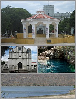 From the top: Park and kiosk, Church, Anda Mira Cave and Atescatempa Lagoon. | |
 Flag  Coat of arms | |
 Jutiapa and its neighbors[a] Jutiapa and its neighbors[a]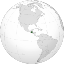 Guatemala on the Western Hemisphere Guatemala on the Western Hemisphere | |
| Country |  Guatemala Guatemala |
| Capital | Jutiapa |
| Municipalities | 17 |
| Government | |
| • Type | Departmental |
| Area | |
| • Department of Guatemala | 3,219 km2 (1,243 sq mi) |
| Population (2018)[1] | |
| • Department of Guatemala | 488,395 |
| • Density | 150/km2 (390/sq mi) |
| • Urban | 249,754 |
| • Religions | Roman Catholicism Evangelicalism |
| Time zone | UTC-6 |
Jutiapa Department is a department of Guatemala that borders along El Salvador and the Pacific Ocean. The capital is the city of Jutiapa. As of 2018, it has a population of 488,395.[1] The department is divided into seventeen municipalities. Jutiapa is the country's southeasternmost department and officially the only department with no Mayan descendants native to the region. The main crops are sorghum, tobacco, onion and corn. The climate is dry. An important attraction is the cattle fair. It is at 405 m above sea level.
The population is ethnically "Ladino" (of European descent & non Mayan-indigenous), though in the northern regions of Jutiapa there are few descendants that once belonged to the Xinca population. The Xinca people were of non-Mayan descent.
The coat of arms contains the cornucopia symbolizing Jutiapa as the barn of the East, supplying Guatemala with most of the grain consumed by the people. The horse and the cow represent the cattle; the books stand for educational and cultural advances. In the background sits La Cruz hill, the firm guardian of the departmental chief town, with the tower or antenna of a Jutiapa radio station. Behind the hill float the clouds, the sky and the sun of Jutiapa, "The Sun City". This coat of arms is placed on the flag between two laurel branches symbolizing the daily triumphs of the sons of Jutiapa. The flag is mainly white, showing in its center the coat of arms adapted and adroned, between two laurel branches.
Municipalities
- Agua Blanca
- Asunción Mita
- Atescatempa
- Comapa
- Conguaco
- El Adelanto
- El Progreso
- Jalpatagua
- Jerez
- Jutiapa
- Moyuta
- Pasaco
- Quesada
- San José Acatempa
- Santa Catarina Mita
- Yupiltepeque
- Zapotitlán
References
- ^
- Santa Rosa
- Jalapa
- Chiquimula
- Lake Güija
- In El Salvador, Santa Ana and Ahuachapán
- ^ a b Citypopulation.de Population of departments in Guatemala
External links
![]() Media related to Jutiapa Department at Wikimedia Commons
Media related to Jutiapa Department at Wikimedia Commons
- Interactive department map
- v
- t
- e

14°16′58″N 89°53′33″W / 14.28278°N 89.89250°W / 14.28278; -89.89250
 | This Guatemala location article is a stub. You can help Wikipedia by expanding it. |
- v
- t
- e


