Interlake Formation
| Interlake Formation (Group) | |
|---|---|
| Stratigraphic range: Llandovery to Ludlow PreꞒ Ꞓ O S D C P T J K Pg N | |
| Type | Geological formation |
| Underlies | Ashern Formation |
| Overlies | Stonewall Formation |
| Thickness | up to 335 metres (1,100 ft)[1] |
| Lithology | |
| Primary | dolomite |
| Location | |
| Coordinates | 51°27′13″N 98°45′37″W / 51.4535°N 98.7603°W / 51.4535; -98.7603 (Interlake Formation) |
| Region | WCSB Williston Basin |
| Country |  Canada Canada United States United States |
| Type section | |
| Named for | Interlake Region, Manitoba |
| Named by | A.D. Baillie, 1951 |
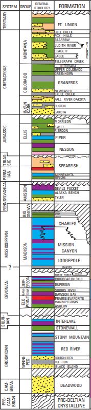
The Interlake Formation is a stratigraphical unit of Silurian age in the Western Canadian Sedimentary Basin.
It takes the name from the Interlake Region in Manitoba, and was first described in outcrop by A.D. Baillie in 1951.[2]
Lithology
The Interlake Formation is composed of very finely crystalline dolomite. [1] Oolitic, stromatolitic and biohermal interbeds also occur.
Distribution
The Interlake Formation is present throughout the Williston Basin.[1] It reaches a maximum thickness of 335 metres (1,100 ft) in the subsurface of North Dakota, and is typically up to 110 metres (360 ft) thick in outcrop in its type locality.
Relationship to other units
The Interlake Formation is overlain with an angular unconformably by the Ashern Formation and sharply overlays the Stonewall Formation.[1]
In the sub-surface it is given group status and contains, in different regions, the following subdivisions:
- Strathclair, Brandon and Cedar Lake Formations
- Lower, Middle and Upper Interlake
- Rupert, Hansen and Risser Formations
- Strathclair, Fife Lake, Guernsey, Cedar Lake and Taylorton Formations
References
- ^ a b c d Lexicon of Canadian Geologic Units. "Formation". Archived from the original on 2009-04-16. Retrieved 2010-02-01.
- ^ Ballie, A.D., 1951 Silurian geology of the Interlake area, Manitoba. Manitoba Department of Mines and Natural Resources, Mines Branch, Pub. 50-1.
- v
- t
- e
- Oil sands and heavy oil
- Frontier exploration and development
- Natural gas liquids
- Natural gas
- Southern Alberta
- Central Alberta
- Northwestern Alberta Plains
- South-central Canadian Rockies foothills
- North-east Plains
- North-central foothills
- Liard River
- Fort Nelson
- Northern Rocky Mountains
- Fort St. John
- Saskatchewan
- Western Manitoba
- Cypress Hills FM
- Ravenscrag FM
- Frenchman FM
- Whitemud FM
- Eastend FM
- Bearpaw FM
- Judith River GRP
- Belly River FM
- Oldman FM
- Foremost FM
- Lea Park FM
- Pakowki FM
- Milk River FM
- Colorado GRP
- Viking FM
- Mannville GRP
- Vanguard FM
- Ellis GRP
- Shaunavon FM
- Piper FM
- Gravelbourg FM
- Gypsum Springs FM
- Watrous FM
- Big Snowy GRP
- Madison GRP
- Three Forks GRP
- Saskatchewan GRP
- Manitoba GRP
- Elk Point GRP
- Interlake FM
- Stonewall FM
- Stony Mountain FM
- Herald FM
- Yeoman FM
- Winnipeg FM
- Deadwood FM
- Canadian Shield


