Heraklion (regional unit)
Regional unit in Greece
Heraklion Περιφερειακή ενότητα Ηρακλείου | |
|---|---|
 Municipalities of Heraklion | |
| 35°10′N 25°10′E / 35.167°N 25.167°E / 35.167; 25.167 | |
| Country | Greece |
| Administrative region | Crete |
| Seat | Heraklion |
| Area | |
| • Total | 2,641 km2 (1,020 sq mi) |
| Population (2021)[1] | |
| • Total | 303,017 |
| • Density | 110/km2 (300/sq mi) |
| Time zone | UTC+2 (EET) |
| • Summer (DST) | UTC+3 (EEST) |
| Postal code | 70x xx, 71x xx |
| Area code(s) | 2810, 289x0 |
| Vehicle registration | HK, HP, HZ |
| Website | www |
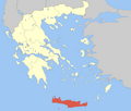
Heraklion (Greek: Περιφερειακή ενότητα Ηρακλείου) is one of the four regional units of Crete. The capital is the city of Heraklion.
Geography
The regional unit of Heraklion borders on the regional units of Rethymno to the west and Lasithi to the east. Farmlands are situated in the central and the northern parts, at the coast and in valleys. The mountains dominate the rest of the regional unit, notably the south. The main mountains are parts of Ida or Idi Mountains to the west and Asterousia in the south. The regional unit includes the island of Dia to the north.
Except for the mountains which receive mild to cool winters unlike northern Greece, the warm to hot Mediterranean climate dominates the regional unit.
Ancient history
Within the Heraklion regional unit's boundaries are a number of significant Neolithic and Minoan settlements, most notably the ancient palace complexes of Knossos and Phaistos.[2][3][4] While both archaeological sites evince Neolithic habitation from 7000 BC, it is the rich finds of Minoan civilisation, which flourished approximately 2800 to 1450 BC, that command the greatest scholarly attention.
Important ancient cities are:
- Knossos
- Phaistos
- Hagia Triada
- Kommos
- Gortys
- Tylissos
- Malia
- Lyttos
- Amnisos
- Kaloi Limenes
Population history
| Year | Pop. | ±% |
|---|---|---|
| 1991[5] | 265,708 | — |
| 2001[5] | 291,225 | +9.6% |
| 2011[5] | 305,490 | +4.9% |
| 2021[1] | 305,017 | −0.2% |
Administration
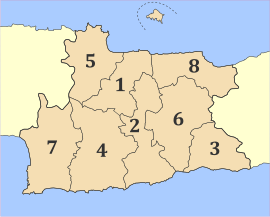
The regional unit Heraklion is subdivided into 8 municipalities. These are (number as in the map in the infobox):[6]
- Archanes-Asterousia (2)
- Faistos (7)
- Gortyna (4)
- Heraklion (Irakleio, 1)
- Hersonissos (Chersonisos, 8)
- Malevizi (5)
- Minoa Pediada (6)
- Viannos (3)
Prefecture
The Heraklion prefecture (Greek: Νομός Ηρακλείου) was created in 1915, after Crete joined with the rest of Greece. As a part of the 2011 Kallikratis government reform, the regional unit Heraklion was created out of the former prefecture Heraklion. The prefecture had the same territory as the present regional unit. At the same time, the municipalities were reorganised, according to the table below.[6]
| New municipality | Old municipalities | Seat |
|---|---|---|
| Archanes-Asterousia | Archanes | Peza |
| Asterousia | ||
| Nikos Kazantzakis | ||
| Faistos | Zaros | Moires |
| Moires | ||
| Tympaki | ||
| Gortyna | Gortyna | Agioi Deka |
| Agia Varvara | ||
| Kofinas | ||
| Rouvas | ||
| Heraklion (Irakleio) | Heraklion | Heraklion |
| Gorgolainis | ||
| Nea Alikarnassos | ||
| Paliani | ||
| Temenos | ||
| Hersonissos (Chersonisos) | Hersonissos | Gournes |
| Episkopi | ||
| Gouves | ||
| Malia | ||
| Malevizi | Gazi | Gazi |
| Krousonas | ||
| Tylisos | ||
| Minoa Pediada | Arkalochori | Evangelismos |
| Thrapsano | ||
| Kasteli | ||
| Viannos | Viannos | Ano Viannos |
Provinces
- Province of Pyrgiotissa - Voroi
- Province of Kainourgio - Moires
- Province of Malevizi - Agios Myronas
- Province of Temenos - Heraklion
- Province of Pediada - Kasteli
- Province of Monofatsi - Pyrgos
- Province of Viannos - Pefkos
Note: Provinces no longer hold any legal status in Greece.
Transport
Notable people
- El Greco (medieval Castilian nickname meaning "the Greek"), by which Δομήνικος Θεοτοκόπουλος Domênikos Theotokópoulos, is best known. (Born 1541, Fodele, Heraklion and died on April 7, 1614, Toledo, Spain), a world-famous painter, sculptor and architect
- Nikos Kazantzakis was born in the village Varvaro (renamed to Myrtia in 1965[7]) The municipal unit in which Myrtia is located, was named after him.
Communications
The following television channels serve the prefecture:
See also
Line notes
- ^ a b "Αποτελέσματα Απογραφής Πληθυσμού - Κατοικιών 2021, Μόνιμος Πληθυσμός κατά οικισμό" [Results of the 2021 Population - Housing Census, Permanent population by settlement] (in Greek). Hellenic Statistical Authority. 29 March 2024.
- ^ A. Evans, 1921
- ^ C. M. Hogan, 2007
- ^ Phaistos profile
- ^ a b c "Απογραφές πληθυσμού 1991,2001,2011 σύμφωνα με την κωδικοποίηση της Απογραφής 2011" (in Greek). Hellenic Statistical Authority. Retrieved 17 April 2024.
- ^ a b "ΦΕΚ A 87/2010, Kallikratis reform law text" (in Greek). Government Gazette.
- ^ Name changes of settlements in Greece
References
- Arthur J. Evans, (1921–35) The Palace of Minos, volumes 1-4
- C. Michael Hogan, Knossos fieldnotes, Modern Antiquarian (2007)
- Ian Swindale, Phaistos, Minoan Crete Retrieved 13 May 2013.
External links
- Monuments in the prefecture of Heraklion
- v
- t
- e
Administrative division of the Crete Region
- Agios Vasileios
- Amari
- Anogeia
- Mylopotamos
- Rethymno
- Regional governor
- Stavros Arnaoutakis (reelected 2014)
- Decentralized Administration
- Crete
| Authority control databases: Geographic |
|
|---|


