Harich, Armenia
40°35′53″N 44°00′27″E / 40.59806°N 44.00750°E / 40.59806; 44.00750
Place in Shirak, Armenia
Harich Հառիճ | |
|---|---|
 The village of Harich and the gorge below as seen from Harichavank. | |
  Harich 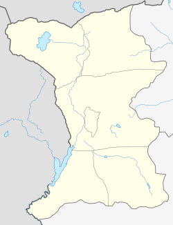 Harich | |
| Coordinates: 40°35′53″N 44°00′27″E / 40.59806°N 44.00750°E / 40.59806; 44.00750 | |
| Country | Armenia |
| Province | Shirak |
| Municipality | Artik |
| Area | |
| • Total | 1.08 km2 (0.42 sq mi) |
| Elevation | 2,020 m (6,630 ft) |
| Population (2008) | |
| • Total | 1,069 |
| Time zone | UTC+4 |
| • Summer (DST) | UTC+5 |
Harich (Armenian: Հառիճ) is a village in the Artik Municipality of the Shirak Province of Armenia. Within the village is the Harichavank Monastery of the 8th century. Across the gorge from the monastery is a 3rd millennium BC fortress and tomb field.
Demographics
Graphs are unavailable due to technical issues. There is more info on Phabricator and on MediaWiki.org. |
Gallery
-
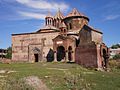 Rear view of 7th century Harichavank Monastery
 -
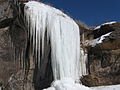 Frozen waterfalls
 -
 Field in Harich


References
- ^ Հայաստանի Հանրապետության բնակավայրերի բառարան [Republic of Armenia settlements dictionary] (PDF) (in Armenian). Yerevan: Cadastre Committee of the Republic of Armenia. 2008. Archived from the original (PDF) on 11 March 2018.
- Harich, Armenia at GEOnet Names Server
- World Gazeteer: Armenia[dead link] – World-Gazetteer.com
- Report of the results of the 2001 Armenian Census, Statistical Committee of Armenia
- Kiesling, Brady (2005), Rediscovering Armenia: Guide, Yerevan, Armenia: Matit Graphic Design Studio
- Kiesling, Brady (June 2000). Rediscovering Armenia: An Archaeological/Touristic Gazetteer and Map Set for the Historical Monuments of Armenia (PDF). Archived (PDF) from the original on 6 November 2021.
- v
- t
- e
 Shirak Province
Capital: Gyumri

Authority control databases | |
|---|---|
| International |
|
| National |
|
 | This article about a location in Shirak Province, Armenia is a stub. You can help Wikipedia by expanding it. |
- v
- t
- e


