Hallingskarvet
Mountain range in southern Norway


Hallingskarvet
Location of the mountain
Show map of Vestland
Hallingskarvet
Hallingskarvet (Buskerud)
Show map of Buskerud
Hallingskarvet
Hallingskarvet (Norway)
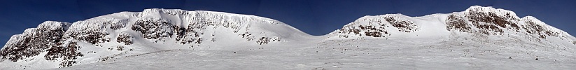
Show map of NorwayHallingskarvet is a mountain range in southern Norway stretching from Geilo to Finse in Vestland and Buskerud counties. The highest point is the 1,933-metre (6,342 ft) tall mountain Folarskardnuten in Hol Municipality in Buskerud county.
In the north, there is a large dammed lake called Strandavatnet. The Bergen Line railway, which runs south of Hallingskarvet, has its highest stop at Finse Station at an elevation of 1,222 metres (4,009 ft).[2]
In 2006, the Hallingskarvet mountain range became part of the Hallingskarvet National Park.
See also
References
| Authority control databases |
|
|---|
- v
- t
- e
 | This article about a mountain, mountain range, or peak in Buskerud is a stub. You can help Wikipedia by expanding it. |
- v
- t
- e


