Grandview Peak
Mountain in Utah, United States


Grandview Peak
Location in Utah
Show map of Utah
Grandview Peak
Grandview Peak (the United States)
Show map of the United StatesRocky Mountains
Grandview Peak is a 9,410-foot-elevation (2,868-meter) mountain summit located in Salt Lake County, Utah, United States.
Description
Grandview Peak is located nine miles (14 km) northeast of Salt Lake City on land managed by Wasatch National Forest. It is the highest point within the boundaries of Salt Lake City.[2][6] The peak is part of the Wasatch Range which is a subrange of the Rocky Mountains. Precipitation runoff from the mountain's north slope drains to Mill Creek, whereas the south slope drains to City Creek. Topographic relief is significant as the summit rises nearly 2,000 feet (610 meters) above City Creek in one mile (1.6 km) and 1,200 feet (366 meters) above Mill Creek in 0.7 mile (1.1 km). This mountain's toponym has been officially adopted by the United States Board on Geographic Names.[4]
References
- ^ Grandview, National Geodetic Survey Data Sheet, noaa.gov, Retrieved 2024-06-12.
- ^ a b "Grandview Peak, Utah". Peakbagger.com. Retrieved 2024-06-12.
- ^ a b c d "Grandview Peak - 9,410' UT". listsofjohn.com. Retrieved 2024-06-12.
- ^ a b "Grandview Peak". Geographic Names Information System. United States Geological Survey, United States Department of the Interior. Retrieved 2024-06-12.
- ^ Reconnaissance of the Grandview Peak Rockslide, Salt Lake County, Utah: A Possible Earthquake-Induced Landslide?, Francis X. Ashland, Utah Geological Survey, Retrieved 2024-06-12.
- ^ "Area Information – Frequently Asked Questions". Salt Lake City Corporation. Archived from the original on October 24, 2006. Retrieved December 11, 2006.
Gallery
-
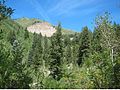
 Southwest aspect
 -
 Grandview Peak landslide scarp on south slope


External links
- Grandview Peak: weather
- National Geodetic Survey Data Sheet
- Grandview Peak (photo): Flickr
- v
- t
- e
Places adjacent to Grandview Peak
| Bountiful | Davis County | Sessions Mountains |
 | ||
| North Salt Lake |  Grandview Peak Grandview Peak | City Creek Meadows |
 | ||
| Salt Lake City | City Creek | Lookout Peak |
Portals:
 Geography
 Geology
 Mountains


