Grade II* listed buildings in Waveney
There are over 20,000 Grade II* listed buildings in England. This page is a list of these buildings in the district of Waveney in Suffolk.
Map all coordinates using OpenStreetMap
Download coordinates as:
- KML
- GPX (all coordinates)
- GPX (primary coordinates)
- GPX (secondary coordinates)
Waveney
| Name | Location | Type | Completed [note 1] | Date designated | Grid ref.[note 2] Geo-coordinates | Entry number [note 3] | Image | |
|---|---|---|---|---|---|---|---|---|
| Brook Farmhouse | All Saints and St. Nicholas, South Elmham | Farmhouse | Early to mid 16th century | 27 April 1987 | TM3205082726 52°23′36″N 1°24′33″E / 52.393336°N 1.409118°E / 52.393336; 1.409118 (Brook Farmhouse) | 1352625 |  Upload Photo | |
| The Elms | All Saints, All Saints and St. Nicholas, South Elmham | Farmhouse | 15th century | 16 March 1972 | TM3325182488 52°23′26″N 1°25′36″E / 52.39069°N 1.42657°E / 52.39069; 1.42657 (The Elms) | 1352623 |  More images | |
| Whaley's | All Saints, All Saints and St. Nicholas, South Elmham | Farmhouse | Mid to late 16th century | 27 April 1987 | TM3394682489 52°23′25″N 1°26′12″E / 52.390403°N 1.436765°E / 52.390403; 1.436765 (Whaley's) | 1032000 | Upload Photo | |
| White House | All Saints and St. Nicholas, South Elmham | Farmhouse | c. 1600 | 1 September 1953 | TM3417582929 52°23′39″N 1°26′26″E / 52.394254°N 1.440431°E / 52.394254; 1.440431 (White House) | 1284035 | Upload Photo | |
| Church of St John the Baptist | Barnby | Parish Church | Medieval | 17 April 1986 | TM4807389938 52°27′04″N 1°38′58″E / 52.451022°N 1.64946°E / 52.451022; 1.64946 (Church of St John the Baptist) | 1032106 |  More images | |
| Ashmans Hall | Barsham | Country House | c. 1820 | 1 September 1953 | TM4128289735 52°27′08″N 1°32′58″E / 52.452239°N 1.549581°E / 52.452239; 1.549581 (Ashmans Hall) | 1032032 | Upload Photo | |
| Northgate House | Beccles | House | 18th century | 16 March 1948 | TM4216290654 52°27′36″N 1°33′47″E / 52.460096°N 1.563172°E / 52.460096; 1.563172 (Northgate House) | 1205862 | Upload Photo | |
| Church of St Michael | Benacre | Parish Church | Medieval | 17 April 1986 | TM5116284460 52°24′02″N 1°41′27″E / 52.400467°N 1.690707°E / 52.400467; 1.690707 (Church of St Michael) | 1032110 | 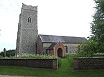 More images | |
| Church of St Margaret | Stoven, Brampton with Stoven | Tower | Medieval | 1 September 1953 | TM4479281610 52°22′40″N 1°35′43″E / 52.377779°N 1.595188°E / 52.377779; 1.595188 (Church of St Margaret) | 1032100 |  More images | |
| Ollands and The Gables | St John's Rd, Bungay | Houses | Post 1654 | 9 May 1949 | TM3409689176 52°27′01″N 1°26′37″E / 52.450347°N 1.443642°E / 52.450347; 1.443642 (Ollands and The Gables) | 1275692 | Upload Photo | |
| Roman Catholic Church of St Edmund | Bungay | Roman Catholic Church | 1889-1901 | 5 March 1998 | TM3369589680 52°27′18″N 1°26′17″E / 52.455041°N 1.438105°E / 52.455041; 1.438105 (Roman Catholic Church of St Edmund) | 1376754 |  More images | |
| Rose Hall | Upper Olland St, Bungay | House | 1739 | 9 May 1949 | TM3371689316 52°27′06″N 1°26′17″E / 52.451766°N 1.438159°E / 52.451766; 1.438159 (Rose Hall) | 1275077 | Upload Photo | |
| Trinity Hall | Staithe Rd, Bungay | House | 18th century | 9 May 1949 | TM3388189756 52°27′20″N 1°26′27″E / 52.455644°N 1.44089°E / 52.455644; 1.44089 (Trinity Hall) | 1216991 |  More images | |
| Church of St Peter | Carlton Colville | Parish Church | Medieval | 17 April 1986 | TM5100090143 52°27′05″N 1°41′33″E / 52.451526°N 1.692594°E / 52.451526; 1.692594 (Church of St Peter) | 1352577 |  More images | |
| Church of St Bartholomew | Corton | Parish Church | Medieval | 27 November 1954 | TM5384498062 52°31′17″N 1°44′25″E / 52.521253°N 1.740382°E / 52.521253; 1.740382 (Church of St Bartholomew) | 1352637 |  More images | |
| Church of St Mary | Flixton, The Saints | Parish Church | Before 1086 | 1 September 1953 | TM3121186693 52°25′45″N 1°23′58″E / 52.429291°N 1.399549°E / 52.429291; 1.399549 (Church of St Mary) | 1031989 |  More images | |
| Dovecote at Flixton Hall | Flixton, The Saints | Dovecote | Early 17th century | 1 September 1953 | TM3049285903 52°25′21″N 1°23′18″E / 52.422505°N 1.388449°E / 52.422505; 1.388449 (Dovecote at Flixton Hall) | 1031986 | Upload Photo | |
| Hill Farmhouse | Flixton, The Saints | Farmhouse | Early 16th century | 27 April 1987 | TM3140487151 52°26′00″N 1°24′10″E / 52.43332°N 1.4027°E / 52.43332; 1.4027 (Hill Farmhouse) | 1031987 | Upload Photo | |
| Church of St Mary the Virgin | Halesworth | Church | 14th century | 21 October 1949 | TM3860277364 52°20′33″N 1°30′05″E / 52.342407°N 1.501412°E / 52.342407; 1.501412 (Church of St Mary the Virgin) | 1267069 | 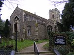 More images | |
| Former Almshouses | Halesworth | Shop | 1949 | 21 October 1949 | TM3859077321 52°20′31″N 1°30′04″E / 52.342027°N 1.501206°E / 52.342027; 1.501206 (Former Almshouses) | 1224060 | 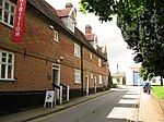 | |
| Gothic House | 1, London Road, Halesworth | House | 1603-1625 | 21 October 1949 | TM3866577335 52°20′32″N 1°30′08″E / 52.34212°N 1.502315°E / 52.34212; 1.502315 (Gothic House) | 1239856 |  More images | |
| The Social Club | Halesworth | Jettied House | 16th century | 21 October 1949 | TM3853777404 52°20′34″N 1°30′02″E / 52.342795°N 1.500488°E / 52.342795; 1.500488 (The Social Club) | 1223564 |  More images | |
| Church of St Peter | Holton | Parish Church | Medieval | 1 September 1953 | TM4025677875 52°20′47″N 1°31′34″E / 52.346271°N 1.526009°E / 52.346271; 1.526009 (Church of St Peter) | 1352566 |  More images | |
| Church of St John the Baptist | Lound | Parish Church | Medieval | 27 November 1954 | TM5063498995 52°31′52″N 1°41′38″E / 52.531107°N 1.693876°E / 52.531107; 1.693876 (Church of St John the Baptist) | 1183409 |  More images | |
| Mutford Hall | Mutford | House | 19th century | 17 April 1986 | TM4809787512 52°25′45″N 1°38′53″E / 52.429246°N 1.648012°E / 52.429246; 1.648012 (Mutford Hall) | 1352581 |  More images | |
| North Cove Hall | North Cove | House | c1760-1770 | 1 September 1953 | TM4648089474 52°26′51″N 1°37′33″E / 52.447579°N 1.625724°E / 52.447579; 1.625724 (North Cove Hall) | 1182794 | 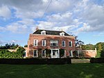 More images | |
| Manor House | Oulton | House | Late 16th century | 13 December 1949 | TM5254494862 52°29′35″N 1°43′08″E / 52.493149°N 1.718837°E / 52.493149; 1.718837 (Manor House) | 1292479 | Upload Photo | |
| Church of St Margaret | Reydon | Parish Church | Medieval | 27 November 1954 | TM4909478189 52°20′43″N 1°39′21″E / 52.345149°N 1.65572°E / 52.345149; 1.65572 (Church of St Margaret) | 1032142 |  More images | |
| Church of All Saints | Ringsfield | Parish Church | Medieval | 1 September 1953 | TM4031588429 52°26′27″N 1°32′04″E / 52.440947°N 1.53444°E / 52.440947; 1.53444 (Church of All Saints) | 1032044 |  More images | |
| Hatton's Farmhouse | Rumburgh | Farmhouse | C20 | 23 April 1986 | TM3617981752 52°22′58″N 1°28′08″E / 52.382832°N 1.468998°E / 52.382832; 1.468998 (Hatton's Farmhouse) | 1283698 | Upload Photo | |
| Rushmere Hall | Rushmere | Farmhouse | Late 16th century | 17 April 1986 | TM4924587330 52°25′38″N 1°39′53″E / 52.427091°N 1.664725°E / 52.427091; 1.664725 (Rushmere Hall) | 1284310 | 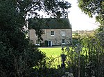 More images | |
| Hill Farmhouse | Shadingfield | Farmhouse | Early-Mid 16th century | 1 September 1953 | TM4346883516 52°23′44″N 1°34′38″E / 52.39547°N 1.57716°E / 52.39547; 1.57716 (Hill Farmhouse) | 1352589 | Upload Photo | |
| Moat Farmhouse | Shadingfield | Farmhouse | Mid 16th century | 1 September 1953 | TM4280485145 52°24′37″N 1°34′07″E / 52.410382°N 1.568602°E / 52.410382; 1.568602 (Moat Farmhouse) | 1032132 | Upload Photo | |
| Barn 30 Metres North of Manor Farmhouse | Shipmeadow | Barn | Late 19th century | 1 November 1988 | TM3790490322 52°27′32″N 1°30′01″E / 52.458987°N 1.500386°E / 52.458987; 1.500386 (Barn 30 Metres North of Manor Farmhouse) | 1352629 | Upload Photo | |
| Church of St Bartholomew | Shipmeadow | Parish Church | Medieval | 1 September 1953 | TM3820289981 52°27′21″N 1°30′16″E / 52.455797°N 1.50452°E / 52.455797; 1.50452 (Church of St Bartholomew) | 1032004 | 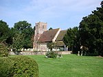 More images | |
| Barn 70 Metres East North East of Park Farmhouse | Somerleyton, Ashby and Herringfleet | Timber Framed Barn | 16th century | 29 January 1987 | TM5040798202 52°31′27″N 1°41′24″E / 52.524097°N 1.689939°E / 52.524097; 1.689939 (Barn 70 Metres East North East of Park Farmhouse) | 1284051 |  | |
| Church of St Mary | Somerleyton, Somerleyton, Ashby and Herringfleet | Parish Church | 15th century | 27 November 1954 | TM4930597211 52°30′57″N 1°40′23″E / 52.515711°N 1.672988°E / 52.515711; 1.672988 (Church of St Mary) | 1183419 |  More images | |
| Herringfleet Marsh Mill | Herringfleet, Somerleyton, Ashby and Herringfleet | Drainage Mill | c. 1820 | 27 November 1954 | TM4654397625 52°31′14″N 1°37′58″E / 52.520681°N 1.632676°E / 52.520681; 1.632676 (Herringfleet Marsh Mill) | 1183297 |  More images | |
| Kitchen Garden of Somerleyton Hall | Somerleyton Park, Somerleyton, Ashby and Herringfleet | Garden | c. 1846 | 29 January 1987 | TM4923997979 52°31′21″N 1°40′21″E / 52.522632°N 1.672593°E / 52.522632; 1.672593 (Kitchen Garden of Somerleyton Hall) | 1031936 | Upload Photo | |
| Somerleyton Hall | Somerleyton Hall, Somerleyton, Ashby and Herringfleet | Country House | 16th century | 29 January 1987 | TM4928397769 52°31′15″N 1°40′23″E / 52.520728°N 1.673083°E / 52.520728; 1.673083 (Somerleyton Hall) | 1198046 |  More images | |
| Stable Court to Somerleyton Hall | Somerleyton Park, Somerleyton, Ashby and Herringfleet | Courtyard | 1846 | 29 January 1987 | TM4930397834 52°31′17″N 1°40′24″E / 52.521302°N 1.673425°E / 52.521302; 1.673425 (Stable Court to Somerleyton Hall) | 1352646 | Upload Photo | |
| Church Farmhouse | Sotherton | Farmhouse | Mid 16th century | 1 September 1953 | TM4415679538 52°21′34″N 1°35′04″E / 52.359472°N 1.584357°E / 52.359472; 1.584357 (Church Farmhouse) | 1183173 |  More images | |
| Church of St Andrew | Sotherton | Parish Church | Medieval | 1 September 1953 | TM4412279484 52°21′32″N 1°35′02″E / 52.359002°N 1.583819°E / 52.359002; 1.583819 (Church of St Andrew) | 1352590 |  More images | |
| Buckenham House | Southwold | House | Early 17th century addition | 21 April 1949 | TM5076376161 52°19′34″N 1°40′43″E / 52.326195°N 1.678657°E / 52.326195; 1.678657 (Buckenham House) | 1384375 | Upload Photo | |
| Lloyds Bank | Southwold | Town House | 1716 | 21 April 1949 | TM5080176122 52°19′33″N 1°40′45″E / 52.325827°N 1.679185°E / 52.325827; 1.679185 (Lloyds Bank) | 1384386 | 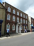 More images | |
| Manor House and Manor Gate including Forecourt Walls | Southwold | House | c. 1750 | 21 April 1949 | TM5069976219 52°19′36″N 1°40′40″E / 52.326744°N 1.677763°E / 52.326744; 1.677763 (Manor House and Manor Gate including Forecourt Walls) | 1384370 |  More images | |
| Sutherland House | 56, High Street, Southwold | House | Remodelled early 19th century | 21 April 1949 | TM5066776289 52°19′39″N 1°40′38″E / 52.327387°N 1.677347°E / 52.327387; 1.677347 (Sutherland House) | 1384369 | Upload Photo | |
| Church of St Peter | Spexhall | Parish Church | 12th century | 1 September 1953 | TM3783280175 52°22′05″N 1°29′32″E / 52.367966°N 1.492121°E / 52.367966; 1.492121 (Church of St Peter) | 1032046 |  More images | |
| The Huntsman and Hounds | Stone Street, Spexhall | Timber Framed House | Mid 16th century | 1 September 1953 | TM3823582638 52°23′24″N 1°29′59″E / 52.389892°N 1.499777°E / 52.389892; 1.499777 (The Huntsman and Hounds) | 1032051 |  More images | |
| Church of St John the Baptist | St John, Ilketshall | Parish Church | Medieval | 1 September 1953 | TM3601887563 52°26′06″N 1°28′15″E / 52.435046°N 1.470732°E / 52.435046; 1.470732 (Church of St John the Baptist) | 1032020 |  More images | |
| Church of St Lawrence | St Lawrence, Ilketshall | Parish Church | 13th century | 1 September 1953 | TM3677586377 52°25′27″N 1°28′52″E / 52.424077°N 1.481007°E / 52.424077; 1.481007 (Church of St Lawrence) | 1197944 |  More images | |
| Boundary Farmhouse | St Margaret, Ilketshall | Farmhouse | Early 16th century | 1 September 1953 | TM3563883460 52°23′54″N 1°27′44″E / 52.398392°N 1.462265°E / 52.398392; 1.462265 (Boundary Farmhouse) | 1032023 |  More images | |
| Rookery Farmhouse | St Margaret's Green, St Margaret, South Elmham | Farmhouse | 16th century | 1 September 1953 | TM3238683467 52°23′59″N 1°24′52″E / 52.399843°N 1.41456°E / 52.399843; 1.41456 (Rookery Farmhouse) | 1198346 |  More images | |
| Church of St Mary | South Elmham St. Mary, otherwise Homersfield | Parish Church | 12th century | 1 September 1953 | TM2855985398 52°25′08″N 1°21′35″E / 52.418783°N 1.359729°E / 52.418783; 1.359729 (Church of St Mary) | 1031994 |  More images | |
| Church of St Peter | St Peter, South Elmham | Parish Church | Norman | 1 September 1953 | TM3359584809 52°24′41″N 1°26′00″E / 52.411372°N 1.433234°E / 52.411372; 1.433234 (Church of St Peter) | 1283860 | 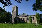 More images | |
| St Peter's Hall | St Peter, South Elmham | House | 19th century | 1 September 1953 | TM3360085342 52°24′58″N 1°26′01″E / 52.416153°N 1.433679°E / 52.416153; 1.433679 (St Peter's Hall) | 1031979 |  More images | |
| Uggeshall Hall | Uggeshall | Farmhouse | C16-C17 | 17 March 1986 | TM4568681510 52°22′35″N 1°36′30″E / 52.376482°N 1.608222°E / 52.376482; 1.608222 (Uggeshall Hall) | 1183331 | 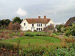 More images | |
| Beacon Farmhouse | Westhall | Farmhouse | Mid 16th century | 1 September 1953 | TM4192881381 52°22′37″N 1°33′11″E / 52.376996°N 1.553032°E / 52.376996; 1.553032 (Beacon Farmhouse) | 1352610 | More images | |
| Slough Farmhouse | Westhall | Farmhouse | Mid 16th century | 23 April 1986 | TM3947483078 52°23′36″N 1°31′06″E / 52.3933°N 1.518263°E / 52.3933; 1.518263 (Slough Farmhouse) | 1198991 | Upload Photo | |
| Weston Hall | Weston | Country House | Late 16th century | 1 September 1953 | TM4259087143 52°25′42″N 1°34′01″E / 52.428404°N 1.56691°E / 52.428404; 1.56691 (Weston Hall) | 1032008 | Upload Photo | |
| Manor Farmhouse | Wissett | Farmhouse | Early 16th century | 23 April 1986 | TM3608579678 52°21′51″N 1°27′58″E / 52.364261°N 1.46616°E / 52.364261; 1.46616 (Manor Farmhouse) | 1032067 | Upload Photo | |
| The Grange | Wissett | House | 16th century | 1 September 1953 | TM3634279495 52°21′45″N 1°28′11″E / 52.362508°N 1.469799°E / 52.362508; 1.469799 (The Grange) | 1199370 | Upload Photo | |
| Church of All Saints | Worlingham | Parish Church | Medieval | 27 June 1986 | TM4451089836 52°27′06″N 1°35′49″E / 52.451712°N 1.597061°E / 52.451712; 1.597061 (Church of All Saints) | 1182968 | 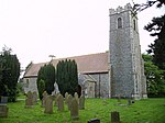 More images | |
| United Reformed Church | Wrentham | Chapel | 1778 | 27 November 1954 | TM4972882703 52°23′07″N 1°40′06″E / 52.385359°N 1.668365°E / 52.385359; 1.668365 (United Reformed Church) | 1032152 |  More images | |
| Church of St Margaret and All Saints | Saxon Rd, Lowestoft | Parish Church | 13th century | 13 December 1949 | TM5386090496 52°27′12″N 1°44′05″E / 52.453372°N 1.734857°E / 52.453372; 1.734857 (Church of St Margaret and All Saints) | 1207045 | 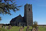 More images | |
| Church of St Peter | Gunton, Lowestoft | Parish Church | 12th century | 13 December 1949 | TM5422995752 52°30′01″N 1°44′39″E / 52.500351°N 1.74428°E / 52.500351; 1.74428 (Church of St Peter) | 1208952 |  More images | |
| Church of St Peter and St John | Kirkley, Lowestoft | Parish Church | Early 15th century | 3 October 1977 | TM5405291567 52°27′46″N 1°44′19″E / 52.462891°N 1.738491°E / 52.462891; 1.738491 (Church of St Peter and St John) | 1207046 | 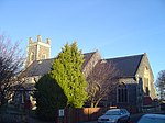 More images | |
| Royal Norfolk and Suffolk Yacht Club | Lowestoft | Sailing Club | 1902-03 | 3 May 1979 | TM5480092618 52°28′19″N 1°45′01″E / 52.471971°N 1.750279°E / 52.471971; 1.750279 (Royal Norfolk and Suffolk Yacht Club) | 1207043 | 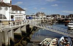 More images | |
| 36 High Street | Lowestoft | House | 1949-50 | 13 December 1949 | TM5516693932 52°29′01″N 1°45′24″E / 52.483587°N 1.75666°E / 52.483587; 1.75666 (36 High Street) | 1292849 |  More images |
Notes
- ^ The date given is the date used by Historic England as significant for the initial building or that of an important part in the structure's description.
- ^ Sometimes known as OSGB36, the grid reference is based on the British national grid reference system used by the Ordnance Survey.
- ^ The "List Entry Number" is a unique number assigned to each listed building and scheduled monument by Historic England.
External links
- v
- t
- e
- Bedfordshire
- Berkshire
- Bristol
- Buckinghamshire
- Cambridgeshire
- Cheshire
- Cornwall
- Cumbria
- Derbyshire
- Devon
- Dorset
- Durham
- East Sussex
- East Riding of Yorkshire
- Essex
- Gloucestershire
- Greater London
- Greater Manchester
- Hampshire
- Herefordshire
- Hertfordshire
- Isle of Wight
- Kent
- Lancashire
- Leicestershire
- Lincolnshire
- Merseyside
- Norfolk
- North Yorkshire
- Northamptonshire
- Northumberland
- Nottinghamshire
- Oxfordshire
- Rutland
- Shropshire
- Somerset
- South Yorkshire
- Staffordshire
- Suffolk
- Surrey
- Tyne and Wear
- Warwickshire
- West Midlands
- West Sussex
- West Yorkshire
- Wiltshire
- Worcestershire
- Allerdale
- Amber Valley
- Ashford
- Babergh
- Barrow-in-Furness
- Basildon
- Basingstoke and Deane
- Bath and North East Somerset
- Bolsover
- Boston
- Bournemouth
- Bradford
- Braintree
- Breckland
- Brentwood
- Brighton and Hove
- Bristol
- Broadland
- Calderdale
- Cambridge
- Camden
- Canterbury
- Carlisle
- Castle Point
- Chelmsford
- Cheltenham
- Cherwell
- Cheshire East
- Cheshire West and Chester
- Chesterfield
- Chiltern
- Christchurch
- Colchester
- Copeland
- Corby
- Cotswold
- Dartford
- Daventry
- Dover
- East Cambridgeshire
- Exeter
- Mendip
- North Somerset
- North Yorkshire (district)
- Poole
- Sedgemoor
- South Somerset
- Stoke-on-Trent
- Taunton Deane
- West Somerset
- York


