Grade II* listed buildings in Thurrock
Map all coordinates using OpenStreetMap
Download coordinates as:
- KML
- GPX (all coordinates)
- GPX (primary coordinates)
- GPX (secondary coordinates)
There are over 20,000 Grade II* listed buildings in England. This page is a list of these buildings in the district of Thurrock in Essex.
Thurrock
| Name | Location | Type | Completed [note 1] | Date designated | Grid ref.[note 2] Geo-coordinates | Entry number [note 3] | Image |
|---|---|---|---|---|---|---|---|
| Kenningtons | Aveley, Thurrock | House | Later | 8 February 1960 | TQ5629781745 51°30′47″N 0°15′04″E / 51.513015°N 0.251018°E / 51.513015; 0.251018 (Kenningtons) | 1147634 |  Upload Photo |
| Bretts Farmhouse | Aveley | Farmhouse | Late 14th century or early 15th century | 8 February 1960 | TQ5598881957 51°30′54″N 0°14′48″E / 51.515005°N 0.246662°E / 51.515005; 0.246662 (Bretts Farmhouse) | 1111561 | Upload Photo |
| Church of St John the Baptist | Mucking | Church | 13th century | 8 February 1960 | TQ6853081182 51°30′16″N 0°25′37″E / 51.504444°N 0.426876°E / 51.504444; 0.426876 (Church of St John the Baptist) | 1337106 |  More images |
| Church of St Mary and All Saints | Langdon Hills | Church | Early 16th century | 28 August 1981 | TQ6728086342 51°33′04″N 0°24′41″E / 51.551169°N 0.411331°E / 51.551169; 0.411331 (Church of St Mary and All Saints) | 1337108 | 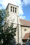 More images |
| Church of St Mary the Virgin | Little Thurrock | Church | 12th century | 8 February 1960 | TQ6262777792 51°28′33″N 0°20′25″E / 51.475716°N 0.34034°E / 51.475716; 0.34034 (Church of St Mary the Virgin) | 1111628 | 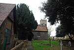 More images |
| Copeland House | Fobbing | A Frame House | 14th century | 8 February 1960 | TQ7167684152 51°31′49″N 0°28′25″E / 51.530177°N 0.473606°E / 51.530177; 0.473606 (Copeland House) | 1337112 | Upload Photo |
| Garden Walls and Gateway at Little Belhus | South Ockendon | Gate | Mid 16th century | 8 February 1960 | TQ5852282186 51°30′59″N 0°17′00″E / 51.516357°N 0.283253°E / 51.516357; 0.283253 (Garden Walls and Gateway at Little Belhus) | 1111580 | Upload Photo |
| Bell Inn | Horndon on the Hill | Jettied House | Late 14th century | 8 February 1960 | TQ6703483265 51°31′25″N 0°24′23″E / 51.5236°N 0.406327°E / 51.5236; 0.406327 (Bell Inn) | 1337114 |  More images |
| High House | Horndon on the Hill | House | Early 18th century | 8 February 1960 | TQ6700583304 51°31′26″N 0°24′21″E / 51.523959°N 0.405928°E / 51.523959; 0.405928 (High House) | 1308738 | Upload Photo |
| Little Belhus | South Ockendon | Timber Framed House | Mid 16th century | 8 February 1960 | TQ5851082154 51°30′58″N 0°16′59″E / 51.516073°N 0.283066°E / 51.516073; 0.283066 (Little Belhus) | 1147262 | Upload Photo |
| Marshall's Cottages | West Tilbury | Cross Wing House | Early 15th century | 8 February 1960 | TQ6606378225 51°28′43″N 0°23′24″E / 51.478609°N 0.389973°E / 51.478609; 0.389973 (Marshall's Cottages) | 1337058 | Upload Photo |
| Officers Barracks, Tilbury Fort | Tilbury | Back to Back House | 1772 | 8 July 1998 | TQ6515475336 51°27′11″N 0°22′32″E / 51.45292°N 0.375547°E / 51.45292; 0.375547 (Officers Barracks, Tilbury Fort) | 1375568 | 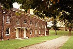 More images |
| Old Plough House | Bulphan | House | 16th century | 8 February 1960 | TQ6421686435 51°33′10″N 0°22′02″E / 51.552904°N 0.367222°E / 51.552904; 0.367222 (Old Plough House) | 1337059 | Upload Photo |
| Orsett House | Orsett | House | Early to mid 18th century | 8 February 1960 | TQ6397681975 51°30′46″N 0°21′42″E / 51.512906°N 0.361689°E / 51.512906; 0.361689 (Orsett House) | 1111610 | Upload Photo |
| Purfleet Play Centre and Attached Wall to South | Purfleet | Boundary Wall | Mid 1760s | 17 April 2009 | TQ5491878592 51°29′06″N 0°13′47″E / 51.485066°N 0.229778°E / 51.485066; 0.229778 (Purfleet Play Centre and Attached Wall to South) | 1393264 | Upload Photo |
| Riverside Station (including Floating Landing Stage) | Tilbury | Railway Station | 1924 | 28 December 1989 | TQ6438875132 51°27′05″N 0°21′52″E / 51.45131°N 0.364438°E / 51.45131; 0.364438 (Riverside Station (including Floating Landing Stage)) | 1111547 |  More images |
| St Clere's Hall | Mucking | Farmhouse | Late 17th century | 8 February 1960 | TQ6752981966 51°30′42″N 0°24′46″E / 51.511784°N 0.412839°E / 51.511784; 0.412839 (St Clere's Hall) | 1111565 | Upload Photo |
| State Cinema | Grays | Shop | 1938 | 22 February 1985 | TQ6134077960 51°28′39″N 0°19′19″E / 51.477594°N 0.321901°E / 51.477594; 0.321901 (State Cinema) | 1111543 | 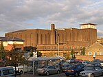 More images |
| Church of St James | West Tilbury | Former Church | Late 11th century or early 12th century | 8 February 1960 | TQ6613677704 51°28′26″N 0°23′27″E / 51.473907°N 0.390779°E / 51.473907; 0.390779 (Church of St James) | 1111541 |  More images |
Notes
- ^ The date given is the date used by Historic England as significant for the initial building or that of an important part in the structure's description.
- ^ Sometimes known as OSGB36, the grid reference is based on the British national grid reference system used by the Ordnance Survey.
- ^ The "List Entry Number" is a unique number assigned to each listed building and scheduled monument by Historic England.
External links
- v
- t
- e
- Bedfordshire
- Berkshire
- Bristol
- Buckinghamshire
- Cambridgeshire
- Cheshire
- Cornwall
- Cumbria
- Derbyshire
- Devon
- Dorset
- Durham
- East Sussex
- East Riding of Yorkshire
- Essex
- Gloucestershire
- Greater London
- Greater Manchester
- Hampshire
- Herefordshire
- Hertfordshire
- Isle of Wight
- Kent
- Lancashire
- Leicestershire
- Lincolnshire
- Merseyside
- Norfolk
- North Yorkshire
- Northamptonshire
- Northumberland
- Nottinghamshire
- Oxfordshire
- Rutland
- Shropshire
- Somerset
- South Yorkshire
- Staffordshire
- Suffolk
- Surrey
- Tyne and Wear
- Warwickshire
- West Midlands
- West Sussex
- West Yorkshire
- Wiltshire
- Worcestershire
- Allerdale
- Amber Valley
- Ashford
- Babergh
- Barrow-in-Furness
- Basildon
- Basingstoke and Deane
- Bath and North East Somerset
- Bolsover
- Boston
- Bournemouth
- Bradford
- Braintree
- Breckland
- Brentwood
- Brighton and Hove
- Bristol
- Broadland
- Calderdale
- Cambridge
- Camden
- Canterbury
- Carlisle
- Castle Point
- Chelmsford
- Cheltenham
- Cherwell
- Cheshire East
- Cheshire West and Chester
- Chesterfield
- Chiltern
- Christchurch
- Colchester
- Copeland
- Corby
- Cotswold
- Dartford
- Daventry
- Dover
- East Cambridgeshire
- Exeter
- Mendip
- North Somerset
- North Yorkshire (district)
- Poole
- Sedgemoor
- South Somerset
- Stoke-on-Trent
- Taunton Deane
- West Somerset
- York


