Grade II* listed buildings in Mid Suffolk
Map all coordinates using OpenStreetMap
Download coordinates as:
- KML
- GPX (all coordinates)
- GPX (primary coordinates)
- GPX (secondary coordinates)
There are over 20,000 Grade II* listed buildings in England. This page is a list of these buildings in the district of Mid Suffolk in Suffolk.
Mid Suffolk
| Name | Location | Type | Completed [note 1] | Date designated | Grid ref.[note 2] Geo-coordinates | Entry number [note 3] | Image |
|---|---|---|---|---|---|---|---|
| Church of St Mary | Akenham, Mid Suffolk | Church | Norman | 9 December 1955 | TM1479048834 52°05′46″N 1°08′04″E / 52.096134°N 1.134341°E / 52.096134; 1.134341 (Church of St Mary) | 1352028 |  More images |
| Ashbocking Hall | Ashbocking | House | c. 1630 | 9 December 1955 | TM1701154570 52°08′48″N 1°10′13″E / 52.146759°N 1.170367°E / 52.146759; 1.170367 (Ashbocking Hall) | 1033081 |  Upload Photo |
| Aspall Hall | Aspall | Hall | Late 16th century | 29 July 1955 | TM1720365353 52°14′37″N 1°10′48″E / 52.243478°N 1.180075°E / 52.243478; 1.180075 (Aspall Hall) | 1032403 |  More images |
| Church of St Mary of Grace | Aspall | Parish Church | Medieval | 29 July 1955 | TM1672364930 52°14′24″N 1°10′22″E / 52.23987°N 1.172785°E / 52.23987; 1.172785 (Church of St Mary of Grace) | 1213437 |  More images |
| Church of St Peter | Athelington | Parish Church | Medieval | 29 July 1955 | TM2103070982 52°17′33″N 1°14′23″E / 52.292481°N 1.23972°E / 52.292481; 1.23972 (Church of St Peter) | 1032562 |  More images |
| Fords Green | Bacton | House | 18th century | 29 July 1955 | TM0615666144 52°15′17″N 1°01′08″E / 52.254825°N 1.018996°E / 52.254825; 1.018996 (Fords Green) | 1032724 | Upload Photo |
| Manor House Christian Rest Home | Bacton | Farmhouse | 19th century | 29 July 1955 | TM0499067153 52°15′52″N 1°00′09″E / 52.264319°N 1.00255°E / 52.264319; 1.00255 (Manor House Christian Rest Home) | 1032752 | 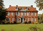 More images |
| Badley Hall | Badley | Farmhouse | 16th century or Early 17th century | 9 December 1955 | TM0602855840 52°09′45″N 1°00′39″E / 52.162364°N 1.010858°E / 52.162364; 1.010858 (Badley Hall) | 1231083 |  More images |
| Barn 100 Metres South East of Badley Hall | Badley | Barn | 17th century | 9 December 1955 | TM0608655809 52°09′43″N 1°00′42″E / 52.162064°N 1.011686°E / 52.162064; 1.011686 (Barn 100 Metres South East of Badley Hall) | 1231085 | Upload Photo |
| Dovecote 60 Metres East of Badley Hall | Badley | Dovecote | 16th century | 9 December 1955 | TM0609655840 52°09′44″N 1°00′43″E / 52.162339°N 1.011851°E / 52.162339; 1.011851 (Dovecote 60 Metres East of Badley Hall) | 1231084 | Upload Photo |
| Badwell Ash Hall | Badwell Ash | Farmhouse | Early 16th century | 15 November 1954 | TM0054269074 52°17′00″N 0°56′19″E / 52.283205°N 0.938603°E / 52.283205; 0.938603 (Badwell Ash Hall) | 1032204 | Upload Photo |
| The Wurlie | Badwell Ash | House | 16th century | 15 November 1954 | TL9907969175 52°17′05″N 0°55′02″E / 52.284643°N 0.917245°E / 52.284643; 0.917245 (The Wurlie) | 1181813 | Upload Photo |
| Shrubland Hall, including attached Screen Walling on East Side, and Terraces and Balustrading on South and West Sides | Shrubland Park, Barham | Country House | 1770-1772 | 9 December 1955 | TM1263152505 52°07′48″N 1°06′19″E / 52.129923°N 1.105163°E / 52.129923; 1.105163 (Shrubland Hall, including attached Screen Walling on East Side, and Terraces and Balustrading on South and West Sides) | 1033252 |  More images |
| Grand Stairs and Grotto, 50 Metres West of Shrubland Hall | Shrubland Park, Barham | Grotto | c. 1850 | 9 December 1955 | TM1256152523 52°07′48″N 1°06′15″E / 52.130112°N 1.104153°E / 52.130112; 1.104153 (Grand Stairs and Grotto, 50 Metres West of Shrubland Hall) | 1279509 |  |
| Terrace known as the Balcony Garden, Including Balustrading and Pavilion, Shrubland Hall | Shrubland Park, Barham | Balustrade | 1849-1850 | 9 December 1955 | TM1258652560 52°07′50″N 1°06′16″E / 52.130434°N 1.10454°E / 52.130434; 1.10454 (Terrace known as the Balcony Garden, Including Balustrading and Pavilion, Shrubland Hall) | 1352051 | Upload Photo |
| Upper Gun Terrace, 10 Metres West of Shrubland Hall | Shrubland Park, Barham | Wall | 1849-1850 | 9 December 1955 | TM1259752514 52°07′48″N 1°06′17″E / 52.130017°N 1.104672°E / 52.130017; 1.104672 (Upper Gun Terrace, 10 Metres West of Shrubland Hall) | 1207906 | Upload Photo |
| Baylham Hall | Baylham | Hall | Early 17th century | 9 December 1955 | TM0917351664 52°07′25″N 1°03′15″E / 52.123691°N 1.054202°E / 52.123691; 1.054202 (Baylham Hall) | 1293336 | Upload Photo |
| Stable Range, 30 Metres South East of Baylham Hall | Baylham | Granary | C20 | 9 December 1955 | TM0922951646 52°07′25″N 1°03′18″E / 52.123509°N 1.055008°E / 52.123509; 1.055008 (Stable Range, 30 Metres South East of Baylham Hall) | 1208099 | Upload Photo |
| Baylham Watermill and Mill House | Baylham | Mill House | Mid 19th century | 9 December 1955 | TM1124252709 52°07′56″N 1°05′06″E / 52.132287°N 1.085028°E / 52.132287; 1.085028 (Baylham Watermill and Mill House) | 1033260 |  More images |
| Church of St Peter | Baylham | Tower | Late 14th century | 9 December 1955 | TM1022851547 52°07′20″N 1°04′10″E / 52.122241°N 1.069518°E / 52.122241; 1.069518 (Church of St Peter) | 1033258 |  More images |
| Bedfield Hall | Bedfield | House | 19th century | 29 July 1955 | TM2275966442 52°15′04″N 1°15′43″E / 52.251034°N 1.262033°E / 52.251034; 1.262033 (Bedfield Hall) | 1198745 |  More images |
| Bedingfield Hall | Bedingfield | Aisled House | Early 14th century | 29 July 1955 | TM1990267756 52°15′50″N 1°13′16″E / 52.263977°N 1.221105°E / 52.263977; 1.221105 (Bedingfield Hall) | 1213518 |  More images |
| Fleming's Hall | Bedingfield | House | C20 | 29 July 1955 | TM1924967788 52°15′52″N 1°12′42″E / 52.264524°N 1.211573°E / 52.264524; 1.211573 (Fleming's Hall) | 1032413 |  More images |
| Church of All Saints | Beyton | Parish Church | Medieval | 15 November 1954 | TL9339562776 52°13′45″N 0°49′49″E / 52.229212°N 0.830362°E / 52.229212; 0.830362 (Church of All Saints) | 1032500 |  More images |
| Chapel of St Botolph | Crown Hill, Botesdale | Grammar School/Chapel of Ease | 1576 | 29 July 1955 | TM0487775890 52°20′34″N 1°00′22″E / 52.3428°N 1.006209°E / 52.3428; 1.006209 (Chapel of St Botolph) | 1352340 |  More images |
| St Catherines | Botesdale | House | Early-Mid 17th century | 16 March 1988 | TM0471275754 52°20′30″N 1°00′13″E / 52.341641°N 1.003707°E / 52.341641; 1.003707 (St Catherines) | 1277591 | Upload Photo |
| Street Farmhouse with Attached Outbuilding | Botesdale | Farmhouse | Early 15th century | 16 March 1988 | TM0491475943 52°20′36″N 1°00′24″E / 52.343262°N 1.006783°E / 52.343262; 1.006783 (Street Farmhouse with Attached Outbuilding) | 1352339 | Upload Photo |
| The Priory with attached Outbuildings and Garden Walls | Botesdale | House | Early 17th century | 29 July 1955 | TM0489175918 52°20′35″N 1°00′23″E / 52.343046°N 1.006431°E / 52.343046; 1.006431 (The Priory with attached Outbuildings and Garden Walls) | 1032608 | Upload Photo |
| Former Church of St Mary | Braiseworth | Parish Church (ruin) | 12th century | 29 July 1955 | TM1379271322 52°17′54″N 1°08′02″E / 52.298395°N 1.133974°E / 52.298395; 1.133974 (Former Church of St Mary) | 1032276 |  More images |
| Bramford House | Bramford | House | c. 1693 | 9 December 1955 | TM1266846413 52°04′31″N 1°06′07″E / 52.075219°N 1.101903°E / 52.075219; 1.101903 (Bramford House) | 1250919 | Upload Photo |
| Church of St Mary | Brome, Brome and Oakley | Parish Church | Medieval | 29 July 1955 | TM1450976464 52°20′39″N 1°08′52″E / 52.344274°N 1.147748°E / 52.344274; 1.147748 (Church of St Mary) | 1352379 |  More images |
| Church of St Nicholas | Oakley, Brome and Oakley | Parish Church | Medieval | 29 July 1955 | TM1571977366 52°21′07″N 1°09′58″E / 52.351896°N 1.166062°E / 52.351896; 1.166062 (Church of St Nicholas) | 1181612 |  More images |
| Park Farmhouse | Brome and Oakley | Farmhouse | Mid 16th century | 14 April 1988 | TM1418476556 52°20′43″N 1°08′35″E / 52.345226°N 1.143043°E / 52.345226; 1.143043 (Park Farmhouse) | 1032524 | Upload Photo |
| Poplar Farmhouse | Lower Oakley, Brome and Oakley | Farmhouse | Late 16th century | 29 July 1955 | TM1613277949 52°21′25″N 1°10′21″E / 52.356967°N 1.172491°E / 52.356967; 1.172491 (Poplar Farmhouse) | 1284932 | Upload Photo |
| Brundish Manor | Brundish | Farmhouse | Early-mid 16th century | 29 July 1955 | TM2639271222 52°17′33″N 1°19′06″E / 52.292454°N 1.318367°E / 52.292454; 1.318367 (Brundish Manor) | 1032864 | Upload Photo |
| Church of St Mary | Burgate | Parish Church | Mid to Late 14th century | 29 July 1955 | TM0824275599 52°20′20″N 1°03′19″E / 52.338922°N 1.055352°E / 52.338922; 1.055352 (Church of St Mary) | 1032797 |  More images |
| Hall Farm House | Burgate | Farmhouse | c. 1400 | 29 July 1955 | TM0800675525 52°20′18″N 1°03′07″E / 52.338347°N 1.051847°E / 52.338347; 1.051847 (Hall Farm House) | 1352234 | Upload Photo |
| Maypole Farmhouse | Buxhall | Farmhouse | c. 1530 | 9 December 1955 | TM0038757779 52°10′55″N 0°55′47″E / 52.181848°N 0.929645°E / 52.181848; 0.929645 (Maypole Farmhouse) | 1033033 | Upload Photo |
| Mockbeggars Hall | Claydon | House | 1621 | 9 December 1955 | TM1311348664 52°05′43″N 1°06′35″E / 52.095256°N 1.109791°E / 52.095256; 1.109791 (Mockbeggars Hall) | 1263022 |  More images |
| Grand Stairs and Grotto 50 Metres West of Shrubland Hall | Shrubland Park, Coddenham | Grotto | c. 1850 | 26 March 1987 | TM1251852534 52°07′49″N 1°06′13″E / 52.130227°N 1.103532°E / 52.130227; 1.103532 (Grand Stairs and Grotto 50 Metres West of Shrubland Hall) | 1033241 | Upload Photo |
| Lower Loggia and attached Balustrading and Steps 150 Metres West of Shrubland Hall | Shrubland Park, Coddenham | Balustrade | c. 1850 | 26 March 1987 | TM1245952548 52°07′49″N 1°06′10″E / 52.130375°N 1.10268°E / 52.130375; 1.10268 (Lower Loggia and attached Balustrading and Steps 150 Metres West of Shrubland Hall) | 1284720 | Upload Photo |
| The Old Lodge and the Post Office | Coddenham | Jettied House | Early-Mid 16th century | 9 December 1955 | TM1342354260 52°08′43″N 1°07′04″E / 52.145373°N 1.117816°E / 52.145373; 1.117816 (The Old Lodge and the Post Office) | 1181646 |  More images |
| Ponderosa & Post Office Cottage | Combs | Farmhouse | Late 14th century or c1400 | 9 December 1955 | TM0432656412 52°10′05″N 0°59′11″E / 52.168132°N 0.986355°E / 52.168132; 0.986355 (Ponderosa & Post Office Cottage) | 1284144 | Upload Photo |
| Church of St Mary | Creeting St. Mary | Parish Church | Medieval | 9 December 1955 | TM0938256703 52°10′08″N 1°03′37″E / 52.168851°N 1.060353°E / 52.168851; 1.060353 (Church of St Mary) | 1033245 |  More images |
| Barn 30 Metres North West of Roydon Hall | Creeting St Peter | Barn | C18-C19 | 9 December 1955 | TM0846458506 52°11′07″N 1°02′53″E / 52.185385°N 1.048057°E / 52.185385; 1.048057 (Barn 30 Metres North West of Roydon Hall) | 1284584 | Upload Photo |
| Creeting Hall | Creeting St Peter | Cross Wing House | Mid 16th century | 9 December 1955 | TM0788856850 52°10′15″N 1°02′19″E / 52.170735°N 1.03863°E / 52.170735; 1.03863 (Creeting Hall) | 1352073 |  More images |
| Roydon Hall | Creeting St. Peter | Farmhouse | Mid or Late 16th century | 9 December 1955 | TM0849358483 52°11′07″N 1°02′54″E / 52.185167°N 1.048466°E / 52.185167; 1.048466 (Roydon Hall) | 1033215 | Upload Photo |
| Church of All Saints | Crowfield | Parish Church | Early 15th century | 9 December 1955 | TM1423257780 52°10′36″N 1°07′55″E / 52.176659°N 1.13184°E / 52.176659; 1.13184 (Church of All Saints) | 1181164 |  More images |
| Ancient House | 3, Gracechurch St, Debenham | Cross Passage House | c. 1540 | 9 December 1955 | TM1736563241 52°13′28″N 1°10′52″E / 52.224456°N 1.181087°E / 52.224456; 1.181087 (Ancient House) | 1032319 | 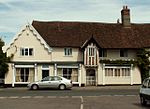 More images |
| Crows Hall (including Bridge over Moat and Walling Lining Inner Side of Moat to West and South) | Debenham | House | 19th century | 9 December 1955 | TM1923462827 52°13′12″N 1°12′29″E / 52.219999°N 1.208138°E / 52.219999; 1.208138 (Crows Hall (including Bridge over Moat and Walling Lining Inner Side of Moat to West and South)) | 1352472 |  More images |
| Lanchester Antiques & Old House & the Gables | 21-25, High St, Debenham | Shop and House | Mid 16th century | 9 December 1955 | TM1739863276 52°13′29″N 1°10′54″E / 52.224757°N 1.181592°E / 52.224757; 1.181592 (Lanchester Antiques & Old House & the Gables) | 1352462 |  More images |
| Swiss Farm Butchers & the Debenham Gallery | 1-3, High St, Debenham | House | Early-Mid 16th century | 9 December 1955 | TM1737163361 52°13′32″N 1°10′53″E / 52.225531°N 1.181252°E / 52.225531; 1.181252 (Swiss Farm Butchers & the Debenham Gallery) | 1032322 | Upload Photo |
| Sycamores | 27, High St, Debenham | House | 19th century | 9 December 1955 | TM1740063256 52°13′28″N 1°10′54″E / 52.224577°N 1.181608°E / 52.224577; 1.181608 (Sycamores) | 1199486 | Upload Photo |
| The Guildhall | 2 Gracechurch st, Debenham | Fire Station | Post 1621 | 9 December 1955 | TM1737463265 52°13′29″N 1°10′52″E / 52.224668°N 1.181234°E / 52.224668; 1.181234 (The Guildhall) | 1199276 | 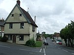 More images |
| 31–37 High Street | Debenham | House | Post 16th century (later) | 9 December 1955 | TM1740963228 52°13′28″N 1°10′54″E / 52.224322°N 1.181722°E / 52.224322; 1.181722 (31–37 High Street) | 1199502 |  More images |
| Church of St John the Baptist | Denham | Parish Church | Medieval | 29 July 1955 | TM1883474784 52°19′39″N 1°12′36″E / 52.327487°N 1.210043°E / 52.327487; 1.210043 (Church of St John the Baptist) | 1032530 |  More images |
| Church of All Saints | Drinkstone | Parish Church | 1330-50 | 15 November 1954 | TL9597261605 52°13′04″N 0°52′03″E / 52.217787°N 0.867367°E / 52.217787; 0.867367 (Church of All Saints) | 1352345 |  More images |
| The Old Rectory | Drinkstone | Vicarage | c. 1760 | 15 November 1954 | TL9598461853 52°13′12″N 0°52′04″E / 52.22001°N 0.867686°E / 52.22001; 0.867686 (The Old Rectory) | 1032622 |  More images |
| Drinkstone Smock Mill | Drinkstone | Mill | 18th century | 15 November 1954 | TL9641362102 52°13′20″N 0°52′27″E / 52.222093°N 0.87410246°E / 52.222093; 0.87410246 (Drinkstone Smock Mill) | 1285454 |  More images |
| Yewtree House | Forward Green, Earl Stonham | House | 16th century | 9 December 1955 | TM0981559922 52°11′51″N 1°04′07″E / 52.197585°N 1.068665°E / 52.197585; 1.068665 (Yewtree House) | 1033226 | Upload Photo |
| Church of St John | Elmswell | Parish Church | Medieval | 15 November 1954 | TL9820263599 52°14′06″N 0°54′04″E / 52.234894°N 0.901134°E / 52.234894; 0.901134 (Church of St John) | 1032468 |  More images |
| Barn at Moor Hall Farm (Moor Hall Farm not included) | Eye | Barn | 18th century | 12 February 1998 | TM1430873161 52°18′53″N 1°08′34″E / 52.314702°N 1.142698°E / 52.314702; 1.142698 (Barn at Moor Hall Farm (Moor Hall Farm not included)) | 1334397 | Upload Photo |
| Cookley Farmhouse | Eye | Farmhouse | c. 1550 | 15 June 1951 | TM1660274155 52°19′22″N 1°10′37″E / 52.322725°N 1.176937°E / 52.322725; 1.176937 (Cookley Farmhouse) | 1316625 | Upload Photo |
| Cranley Hall | Eye | Farmhouse | Mid 15th century | 15 June 1951 | TM1524072835 52°18′41″N 1°09′22″E / 52.311412°N 1.156141°E / 52.311412; 1.156141 (Cranley Hall) | 1316627 | Upload Photo |
| Stayer House | Eye | Kitchen | World War II | 15 June 1951 | TM1481373716 52°19′10″N 1°09′02″E / 52.319487°N 1.150449°E / 52.319487; 1.150449 (Stayer House) | 1316595 | 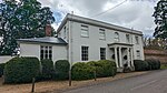 More images |
| The Cottage & White House | Eye | House | Early 18th century | 15 June 1951 | TM1483173851 52°19′14″N 1°09′03″E / 52.320692°N 1.150799°E / 52.320692; 1.150799 (The Cottage & White House) | 1316616 |  More images |
| Town Hall | Eye | Town Hall | 1857 | 20 October 1971 | TM1451273886 52°19′16″N 1°08′46″E / 52.321131°N 1.146148°E / 52.321131; 1.146148 (Town Hall) | 1316536 |  More images |
| 5 Broad Street | Eye | House | c. 1480 | 15 June 1951 | TM1454573868 52°19′15″N 1°08′48″E / 52.320956°N 1.14662°E / 52.320956; 1.14662 (5 Broad Street) | 1316524 |  |
| Church of St Peter | Felsham | Parish Church | Medieval | 15 November 1954 | TL9468157005 52°10′37″N 0°50′45″E / 52.17694°N 0.845853°E / 52.17694; 0.845853 (Church of St Peter) | 1032627 | 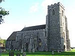 More images |
| Church Farmhouse | Gislingham Rd, Finningham | House | Late 15th century | 14 June 1987 | TM0683869380 52°17′01″N 1°01′51″E / 52.283621°N 1.030955°E / 52.283621; 1.030955 (Church Farmhouse) | 1033145 | Upload Photo |
| Yew Tree House and Amberley | Church Lane, Finningham | House | Mid 16th century | 29 July 1955 | TM0664869475 52°17′04″N 1°01′42″E / 52.284545°N 1.028232°E / 52.284545; 1.028232 (Yew Tree House and Amberley) | 1033143 | Upload Photo |
| Barn 70 Metres South of Framsden Hall | Framsden | Outbuilding | 19th century | 9 December 1955 | TM2059360002 52°11′39″N 1°13′34″E / 52.1941°N 1.22616°E / 52.1941; 1.22616 (Barn 70 Metres South of Framsden Hall) | 1181297 | Upload Photo |
| Boundary Farmhouse | Framsden | Farmhouse | Mid 16th century | 9 December 1955 | TM1867860782 52°12′07″N 1°11′55″E / 52.201864°N 1.198692°E / 52.201864; 1.198692 (Boundary Farmhouse) | 1033058 | 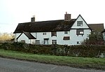 More images |
| Post Mill | Framsden | Flour Mill | c. 1740 | 9 December 1955 | TM1918159753 52°11′33″N 1°12′19″E / 52.192427°N 1.205375°E / 52.192427; 1.205375 (Post Mill) | 1352134 | 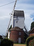 More images |
| Stable, 50 Metres South of Boundary Farmhouse | Framsden | Stable | Early or Mid 17th century | 9 December 1955 | TM1866260735 52°12′05″N 1°11′54″E / 52.201448°N 1.198428°E / 52.201448; 1.198428 (Stable, 50 Metres South of Boundary Farmhouse) | 1033059 | Upload Photo |
| Barn Approximately 50 Metres West South West of Church Farm Stable | Fressingfield | Aisled Barn | Late C13-Early 14th century | 3 June 1997 | TM2601777580 52°20′59″N 1°19′02″E / 52.349672°N 1.317146°E / 52.349672; 1.317146 (Barn Approximately 50 Metres West South West of Church Farm Stable) | 1245363 | Upload Photo |
| Fressingfield Hall | Fressingfield | Farmhouse | Early 17th century | 29 July 1955 | TM2665777657 52°21′00″N 1°19′36″E / 52.350099°N 1.326578°E / 52.350099; 1.326578 (Fressingfield Hall) | 1352192 | Upload Photo |
| The Fox and Goose | Fressingfield | Inn | 19th century | 29 July 1955 | TM2611477453 52°20′55″N 1°19′07″E / 52.348493°N 1.318483°E / 52.348493; 1.318483 (The Fox and Goose) | 1032967 | 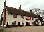 More images |
| Tithe Farmhouse | Fressingfield | Farmhouse | Mid 14th century | 21 October 1987 | TM2680777038 52°20′40″N 1°19′42″E / 52.344482°N 1.328359°E / 52.344482; 1.328359 (Tithe Farmhouse) | 1032927 | Upload Photo |
| Ufford Hall | Fressingfield | Farmhouse | Late 16th century | 29 July 1955 | TM2727574605 52°19′21″N 1°20′01″E / 52.322452°N 1.333573°E / 52.322452; 1.333573 (Ufford Hall) | 1032930 | 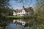 More images |
| Gedding Hall with Bridge attached to South Side of Gatehouse | Gedding | House | Early 16th century | 15 November 1954 | TL9538758565 52°11′27″N 0°51′25″E / 52.190698°N 0.857063°E / 52.190698; 0.857063 (Gedding Hall with Bridge attached to South Side of Gatehouse) | 1032593 |  More images |
| Gipping Lone | Gipping | House | c. 1600 | 9 December 1955 | TM0721864152 52°14′12″N 1°02′00″E / 52.236542°N 1.033311°E / 52.236542; 1.033311 (Gipping Lone) | 1180773 | Upload Photo |
| Ivy House Farmhouse | Gislingham | House | Late 15th century | 29 July 1955 | TM0768471880 52°18′21″N 1°02′42″E / 52.305746°N 1.044879°E / 52.305746; 1.044879 (Ivy House Farmhouse) | 1180705 |  More images |
| Manor House | Gislingham | House | Late 15th century | 29 July 1955 | TM0649572064 52°18′28″N 1°01′39″E / 52.307846°N 1.027578°E / 52.307846; 1.027578 (Manor House) | 1033163 | Upload Photo |
| The Old Guildhall | Gislingham | House | Late 15th century | 29 July 1955 | TM0738571812 52°18′19″N 1°02′26″E / 52.305248°N 1.040458°E / 52.305248; 1.040458 (The Old Guildhall) | 1180771 | Upload Photo |
| Church of St Mary | Gosbeck | Parish Church | Possibly 10th century or 11th century | 9 December 1955 | TM1506255622 52°09′25″N 1°08′33″E / 52.156964°N 1.142593°E / 52.156964; 1.142593 (Church of St Mary) | 1181491 | 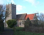 More images |
| Butterfly Farmhouse | Great Finborough | Farmhouse | c. 1570 | 22 January 1988 | TM0036456361 52°10′09″N 0°55′43″E / 52.169125°N 0.928473°E / 52.169125; 0.928473 (Butterfly Farmhouse) | 1197984 | Upload Photo |
| New Bells Farmhouse | Haughley Green, Haughley | Farmhouse | c. 1530 | 9 December 1955 | TM0352964072 52°14′14″N 0°58′46″E / 52.237199°N 0.979317°E / 52.237199; 0.979317 (New Bells Farmhouse) | 1032705 | Upload Photo |
| Elm Farmhouse | Helmingham | Farmhouse | Early 17th century | 22 September 1987 | TM1967856948 52°10′01″N 1°12′39″E / 52.167051°N 1.210819°E / 52.167051; 1.210819 (Elm Farmhouse) | 1033040 | 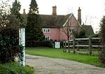 More images |
| Old Hall Farmhouse | Hemingstone | Farmhouse | Early 17th century | 22 September 1987 | TM1523953089 52°08′03″N 1°08′37″E / 52.134157°N 1.143574°E / 52.134157; 1.143574 (Old Hall Farmhouse) | 1182665 |  More images |
| Stonewall Farmhouse | Hemingstone | Farmhouse | c. 1600 | 9 December 1955 | TM1516754249 52°08′41″N 1°08′36″E / 52.144598°N 1.143257°E / 52.144598; 1.143257 (Stonewall Farmhouse) | 1352152 |  More images |
| Walnut Tree Farmhouse | Henley | Farmhouse | Mid 15th century to Mid 16th century | 24 January 1986 | TM1558251808 52°07′21″N 1°08′52″E / 52.122524°N 1.147766°E / 52.122524; 1.147766 (Walnut Tree Farmhouse) | 1251354 | Upload Photo |
| Church of St Mary | Horham | Parish Church | Medieval | 29 July 1955 | TM2103372446 52°18′20″N 1°14′27″E / 52.305621°N 1.240723°E / 52.305621; 1.240723 (Church of St Mary) | 1032540 | 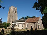 More images |
| Abbey Farmhouse | Hoxne | Farmhouse | Early 17th century | 29 July 1955 | TM1831576400 52°20′32″N 1°12′13″E / 52.342199°N 1.203488°E / 52.342199; 1.203488 (Abbey Farmhouse) | 1032502 |  More images |
| Chickering Corner Farmhouse | Hoxne | Farmhouse | C16-C17 | 29 July 1955 | TM2055176409 52°20′29″N 1°14′11″E / 52.341386°N 1.236262°E / 52.341386; 1.236262 (Chickering Corner Farmhouse) | 1181159 | Upload Photo |
| Haywards Farm Cottage | Chickering, Hoxne | Farmhouse | 16th century | 29 July 1955 | TM2056076418 52°20′29″N 1°14′11″E / 52.341463°N 1.2364°E / 52.341463; 1.2364 (Haywards Farm Cottage) | 1032543 | Upload Photo |
| Red House Farmhouse | South Green, Hoxne | Farmhouse | Early 16th century | 29 July 1955 | TM1733675003 52°19′48″N 1°11′18″E / 52.330047°N 1.188238°E / 52.330047; 1.188238 (Red House Farmhouse) | 1374915 | Upload Photo |
| The Swan (including attached Outbuildings) | Hoxne | Jettied House | Early 16th century | 29 July 1955 | TM1797677190 52°20′58″N 1°11′57″E / 52.349425°N 1.199032°E / 52.349425; 1.199032 (The Swan (including attached Outbuildings)) | 1352375 |  More images |
| Thorpe Hall | Hoxne | House | Late 16th century | 29 July 1955 | TM2118073783 52°19′03″N 1°14′38″E / 52.317562°N 1.243754°E / 52.317562; 1.243754 (Thorpe Hall) | 1352386 | Upload Photo |
| Church of St Michael | Hunston | Parish Church | Medieval | 9 May 1988 | TL9758568048 52°16′30″N 0°53′41″E / 52.275062°N 0.894712°E / 52.275062; 0.894712 (Church of St Michael) | 1182395 |  More images |
| Church of All Saints | Kenton | Parish Church | Medieval | 29 July 1955 | TM1913965913 52°14′52″N 1°12′31″E / 52.247738°N 1.208748°E / 52.247738; 1.208748 (Church of All Saints) | 1283114 | 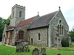 More images |
| Church of St Mary | Langham | Parish Church | 14th century | 15 November 1954 | TL9805669024 52°17′01″N 0°54′08″E / 52.283656°N 0.902179°E / 52.283656; 0.902179 (Church of St Mary) | 1352527 |  More images |
| Langham Hall | Langham | Manor House | Early 18th century | 15 November 1954 | TL9786269030 52°17′02″N 0°53′58″E / 52.28378°N 0.899343°E / 52.28378; 0.899343 (Langham Hall) | 1181875 |  More images |
| Aldridge's Farmhouse | Laxfield | Farmhouse | First half of 14th century | 18 December 1987 | TM2737173463 52°18′44″N 1°20′03″E / 52.312163°N 1.334208°E / 52.312163; 1.334208 (Aldridge's Farmhouse) | 1180914 |  More images |
| Old Guildhall | Laxfield | Guildhall/Museum | c. 1520 | 29 July 1955 | TM2962272380 52°18′05″N 1°21′59″E / 52.301508°N 1.366432°E / 52.301508; 1.366432 (Old Guildhall) | 1180990 |  More images |
| Waterloo House | Laxfield | House | Early-mid 16th century | 29 July 1955 | TM2973172473 52°18′08″N 1°22′05″E / 52.302297°N 1.368091°E / 52.302297; 1.368091 (Waterloo House) | 1180816 | Upload Photo |
| White House Farmhouse | Laxfield | Farmhouse | Early 15th century | 18 December 1987 | TM2740973150 52°18′34″N 1°20′04″E / 52.309338°N 1.334553°E / 52.309338; 1.334553 (White House Farmhouse) | 1285326 | Upload Photo |
| Church of St Mary | Little Finborough | Parish Church | Medieval | 9 December 1955 | TM0185854963 52°09′22″N 0°56′58″E / 52.156029°N 0.949457°E / 52.156029; 0.949457 (Church of St Mary) | 1032984 | 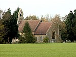 More images |
| Church of St Mary the Virgin | Mellis | Parish Church | Early 14th century | 29 July 1955 | TM0948474321 52°19′37″N 1°04′22″E / 52.326976°N 1.072759°E / 52.326976; 1.072759 (Church of St Mary the Virgin) | 1181735 |  More images |
| Elm Tree Farmhouse | Mellis | House | Late 16th century | 29 July 1955 | TM1042574767 52°19′50″N 1°05′13″E / 52.33062°N 1.086825°E / 52.33062; 1.086825 (Elm Tree Farmhouse) | 1181795 | Upload Photo |
| Mendham Lodge | Mendham | Farmhouse | 16th century | 29 July 1955 | TM2721381875 52°23′16″N 1°20′15″E / 52.387726°N 1.337582°E / 52.387726; 1.337582 (Mendham Lodge) | 1284665 | Upload Photo |
| Middleton Hall | Mendham | Farmhouse | Early 16th century | 29 July 1955 | TM2870383550 52°24′08″N 1°21′38″E / 52.402138°N 1.36058°E / 52.402138; 1.36058 (Middleton Hall) | 1032939 | Upload Photo |
| Elms Farmhouse | Mendlesham | Farmhouse | Late 15th century | 29 July 1955 | TM1031265353 52°14′46″N 1°04′45″E / 52.246152°N 1.079299°E / 52.246152; 1.079299 (Elms Farmhouse) | 1352508 | Upload Photo |
| Read Hall | Mickfield | Farmhouse | Early 15th century | 26 July 1979 | TM1266962673 52°13′16″N 1°06′44″E / 52.221188°N 1.112086°E / 52.221188; 1.112086 (Read Hall) | 1183190 | Upload Photo |
| The Ancient House | 1 & 3, King William St, Needham Market | House | Early or Mid 16th century | 9 December 1955 | TM0879755250 52°09′22″N 1°03′03″E / 52.156028°N 1.050919°E / 52.156028; 1.050919 (The Ancient House) | 1254336 | Upload Photo |
| The Bull Inn | Needham Market | Jettied House | Early 16th century | 9 December 1955 | TM0881355135 52°09′18″N 1°03′04″E / 52.154989°N 1.051082°E / 52.154989; 1.051082 (The Bull Inn) | 1277416 |  More images |
| The Limes Hotel | Needham Market | Steps | 1986 | 9 December 1955 | TM0877255121 52°09′18″N 1°03′02″E / 52.154879°N 1.050475°E / 52.154879; 1.050475 (The Limes Hotel) | 1253662 |  More images |
| Tudor House | 11, High St, Needham Market | House | 16th century | 9 December 1955 | TM0873855167 52°09′19″N 1°03′00″E / 52.155305°N 1.050007°E / 52.155305; 1.050007 (Tudor House) | 1253664 | Upload Photo |
| 93 High Street | Needham Market | House | Early 18th century | 9 December 1955 | TM0878255092 52°09′17″N 1°03′02″E / 52.154615°N 1.050603°E / 52.154615; 1.050603 (93 High Street) | 1253661 | Upload Photo |
| High Hall | Nettlestead | House | 1620-1630 | 9 December 1955 | TM0860650248 52°06′40″N 1°02′42″E / 52.111193°N 1.045065°E / 52.111193; 1.045065 (High Hall) | 1250944 |  More images |
| Tudor Grange | Somersham, Nettlestead | Farmhouse | Mid 16th century | 9 December 1955 | TM0829148995 52°06′00″N 1°02′23″E / 52.100062°N 1.039706°E / 52.100062; 1.039706 (Tudor Grange) | 1263029 |  More images |
| Barn 200 Metres West of Halls Farmhouse | Norton | Barn | 18th century | 9 May 1988 | TL9579666730 52°15′50″N 0°52′04″E / 52.263868°N 0.867761°E / 52.263868; 0.867761 (Barn 200 Metres West of Halls Farmhouse) | 1352406 | Upload Photo |
| Church of St Andrew | Norton | Parish Church | Medieval | 15 November 1954 | TL9622366320 52°15′36″N 0°52′26″E / 52.260034°N 0.873772°E / 52.260034; 0.873772 (Church of St Andrew) | 1352404 |  More images |
| Little Haugh Hall | Norton | Manor House | c. 1730 | 15 November 1954 | TL9521766647 52°15′48″N 0°51′33″E / 52.263328°N 0.85924°E / 52.263328; 0.85924 (Little Haugh Hall) | 1352425 |  More images |
| Manor Farmhouse | Norton Little Green, Norton | Farmhouse | Medieval | 15 November 1954 | TL9753866429 52°15′38″N 0°53′35″E / 52.260543°N 0.893077°E / 52.260543; 0.893077 (Manor Farmhouse) | 1284431 |  More images |
| Church of St Michael | Occold | Parish Church | Medieval | 29 July 1955 | TM1557870863 52°17′37″N 1°09′35″E / 52.293577°N 1.15983°E / 52.293577; 1.15983 (Church of St Michael) | 1352447 |  More images |
| Old Newton Hall | Old Newton with Dagworth | Farmhouse | 19th century | 9 December 1955 | TM0673761841 52°12′58″N 1°01′30″E / 52.215975°N 1.024866°E / 52.215975; 1.024866 (Old Newton Hall) | 1181768 |  More images |
| Ward Green Farmhouse | Ward Green, Old Newton with Dagworth | Farmhouse | Early 15th century | 9 December 1955 | TM0507564009 52°14′10″N 1°00′07″E / 52.23606°N 1.001887°E / 52.23606; 1.001887 (Ward Green Farmhouse) | 1032689 | Upload Photo |
| Brackendale | Palgrave | House | C20 | 29 July 1955 | TM1156478397 52°21′46″N 1°06′21″E / 52.362769°N 1.1058°E / 52.362769; 1.1058 (Brackendale) | 1032778 | Upload Photo |
| Church of St Catherine | Pettaugh | Parish Church | Medieval | 9 December 1955 | TM1678759617 52°11′32″N 1°10′13″E / 52.192152°N 1.17032°E / 52.192152; 1.17032 (Church of St Catherine) | 1182764 |  More images |
| Church Cottage | Rattlesden | Open Hall House | Pre 1800 | 15 November 1954 | TL9784759027 52°11′38″N 0°53′36″E / 52.19397°N 0.893272°E / 52.19397; 0.893272 (Church Cottage) | 1352360 |  More images |
| Folly Lodge known as Dove House | Redgrave Park, Redgrave | Lodge | 1765-70 | 29 July 1955 | TM0629476724 52°20′59″N 1°01′39″E / 52.349757°N 1.027491°E / 52.349757; 1.027491 (Folly Lodge known as Dove House) | 1261272 | Upload Photo |
| The Pink House | Redgrave | House | 17th century | 29 July 1955 | TM0421978161 52°21′48″N 0°59′53″E / 52.363434°N 0.997944°E / 52.363434; 0.997944 (The Pink House) | 1261273 | Upload Photo |
| Broomhills | Rickinghall Inferior | House | 19th century | 15 November 1954 | TM0408776410 52°20′52″N 0°59′42″E / 52.347763°N 0.994944°E / 52.347763; 0.994944 (Broomhills) | 1064775 | Upload Photo |
| Hamblyn House | Rickinghall Inferior | Timber Framed House | Mid 17th century | 29 July 1955 | TM0463675714 52°20′29″N 1°00′09″E / 52.34131°N 1.002569°E / 52.34131; 1.002569 (Hamblyn House) | 1359125 | Upload Photo |
| Barn, 80 Metres South West of Ringshall Hall | Ringshall | House | 1993 | 9 December 1955 | TM0427952736 52°08′07″N 0°59′00″E / 52.135145°N 0.98346°E / 52.135145; 0.98346 (Barn, 80 Metres South West of Ringshall Hall) | 1352190 | Upload Photo |
| Buck's Hall | Rishangles | Farmhouse | Mid 14th century | 23 June 1988 | TM1670267347 52°15′42″N 1°10′26″E / 52.261574°N 1.174027°E / 52.261574; 1.174027 (Buck's Hall) | 1352451 | Upload Photo |
| The Old Church | Rishangles, Mid Suffolk | Parish Church/House | c. 1200 | 29 July 1955 | TM1605268646 52°16′25″N 1°09′55″E / 52.27349°N 1.165349°E / 52.27349; 1.165349 (The Old Church) | 1032380 |  More images |
| Church of King Charles the Martyr | Shelland Green, Shelland | Parish Church | Medieval | 9 December 1955 | TM0035260228 52°12′14″N 0°55′50″E / 52.20385°N 0.930581°E / 52.20385; 0.930581 (Church of King Charles the Martyr) | 1352321 |  More images |
| Church of St Margaret | Southolt | Parish Church | 15th century | 29 July 1955 | TM1934168870 52°16′27″N 1°12′49″E / 52.2742°N 1.213622°E / 52.2742; 1.213622 (Church of St Margaret) | 1288635 |  More images |
| Church of All Saints | Stoke Ash | Parish Church | Medieval | 29 July 1955 | TM1149970423 52°17′28″N 1°05′59″E / 52.291211°N 1.099835°E / 52.291211; 1.099835 (Church of All Saints) | 1181895 |  More images |
| East End Manor | Stonham Aspal | Farmhouse | Mid 15th century | 9 December 1955 | TM1530259871 52°11′42″N 1°08′56″E / 52.195014°N 1.148791°E / 52.195014; 1.148791 (East End Manor) | 1033171 | Upload Photo |
| Clock House | Stonham Parva | Farmhouse | Mid or Late 15th century | 9 December 1955 | TM1149161189 52°12′30″N 1°05′38″E / 52.208319°N 1.093941°E / 52.208319; 1.093941 (Clock House) | 1284270 | 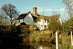 More images |
| Abbot's Hall | Crowe St, Stowmarket | House | 1709 | 28 July 1950 | TM0485458523 52°11′13″N 0°59′43″E / 52.186889°N 0.995338°E / 52.186889; 0.995338 (Abbot's Hall) | 1195859 | 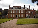 More images |
| 3, Station Road | Stowmarket | House | Early 15th century | 19 April 1972 | TM0488958704 52°11′19″N 0°59′45″E / 52.188501°N 0.995958°E / 52.188501; 0.995958 (3, Station Road) | 1297869 | Upload Photo |
| Lynton House | 10, Station Rd, Stowmarket | House | Mid 18th century | 28 July 1950 | TM0498658732 52°11′19″N 0°59′51″E / 52.188716°N 0.997392°E / 52.188716; 0.997392 (Lynton House) | 1209660 | 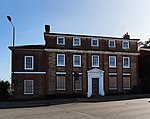 More images |
| Museum of East Anglian Life Tithe Barn | Stowmarket | Grange | 15th century | 28 July 1950 | TM0471958506 52°11′12″N 0°59′36″E / 52.186786°N 0.993356°E / 52.186786; 0.993356 (Museum of East Anglian Life Tithe Barn) | 1195880 | Upload Photo |
| The Cedars Hotel | Needham Rd, Stowmarket | House | Early 17th century | 28 July 1950 | TM0584557485 52°10′38″N 1°00′33″E / 52.177201°N 1.009184°E / 52.177201; 1.009184 (The Cedars Hotel) | 1209561 |  More images |
| The Meadlands Public House | Needham Rd, Stowmarket | House | Late C20 | 19 April 1972 | TM0571357725 52°10′46″N 1°00′27″E / 52.179405°N 1.007401°E / 52.179405; 1.007401 (The Meadlands Public House) | 1195875 | Upload Photo |
| The Rookery | 15 & 15a, Tavern St, Stowmarket | House | 1770 | 28 July 1950 | TM0475058681 52°11′18″N 0°59′38″E / 52.188346°N 0.993914°E / 52.188346; 0.993914 (The Rookery) | 1297873 | Upload Photo |
| The Stricklands | Stricklands Rd, Stowmarket | House | Late 18th century | 28 July 1950 | TM0493358396 52°11′09″N 0°59′47″E / 52.185719°N 0.996415°E / 52.185719; 0.996415 (The Stricklands) | 1209708 | Upload Photo |
| Valley Farmhouse | Stowmarket | Farmhouse | Late 15th century | 28 July 1950 | TM0437757917 52°10′54″N 0°59′17″E / 52.181625°N 0.988005°E / 52.181625; 0.988005 (Valley Farmhouse) | 1195896 | Upload Photo |
| Columbine Hall | Stowupland, Mid Suffolk | Farmhouse | 18th century and 19th century | 15 March 1988 | TM0675660848 52°12′25″N 1°01′28″E / 52.207053°N 1.024538°E / 52.207053; 1.024538 (Columbine Hall) | 1352322 |  More images |
| Broad End Farmhouse | Stradbroke, Mid Suffolk | Farmhouse | Second half of 14th century | 29 July 1955 | TM2626074357 52°19′14″N 1°19′07″E / 52.320646°N 1.31854°E / 52.320646; 1.31854 (Broad End Farmhouse) | 1032844 | Upload Photo |
| Church of All Saints | Stradbroke | Parish Church | Medieval | 29 July 1955 | TM2319173980 52°19′07″N 1°16′24″E / 52.318517°N 1.273338°E / 52.318517; 1.273338 (Church of All Saints) | 1032854 |  More images |
| Hill House Farmhouse | Battlesea Green, Stradbroke | Farmhouse | 16th century | 29 July 1955 | TM2258275410 52°19′54″N 1°15′55″E / 52.331599°N 1.265364°E / 52.331599; 1.265364 (Hill House Farmhouse) | 1181184 | Upload Photo |
| Church of All Saints | Stuston | Parish Church | 12th century or 13th century | 29 July 1955 | TM1346177857 52°21′26″N 1°08′00″E / 52.357187°N 1.133273°E / 52.357187; 1.133273 (Church of All Saints) | 1032794 | 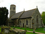 More images |
| Church of St Mary | Syleham | Parish Church | C11/C12 | 29 July 1955 | TM2049278952 52°21′51″N 1°14′13″E / 52.364235°N 1.237066°E / 52.364235; 1.237066 (Church of St Mary) | 1032919 |  More images |
| Gatehouse Farmhouse | Syleham | Farmhouse | Mid 16th century | 29 July 1955 | TM1922477386 52°21′02″N 1°13′03″E / 52.350687°N 1.217453°E / 52.350687; 1.217453 (Gatehouse Farmhouse) | 1182408 | Upload Photo |
| Monks Hall | Syleham | Farmhouse | c. 1600 | 29 July 1955 | TM2016178470 52°21′36″N 1°13′55″E / 52.360041°N 1.231897°E / 52.360041; 1.231897 (Monks Hall) | 1032921 | 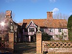 More images |
| Tannington Hall | Tannington | House | 19th century | 29 July 1955 | TM2479068729 52°16′15″N 1°17′36″E / 52.270736°N 1.293257°E / 52.270736; 1.293257 (Tannington Hall) | 1215204 | Upload Photo |
| Church of All Saints | Thorndon | Parish Church | Early 13th century | 29 July 1955 | TM1419669661 52°17′00″N 1°08′20″E / 52.283327°N 1.138834°E / 52.283327; 1.138834 (Church of All Saints) | 1215792 |  More images |
| Shorts Farmhouse | Thorndon | Farmhouse | Mid 16th century | 23 June 1988 | TM1425768018 52°16′07″N 1°08′19″E / 52.268555°N 1.138684°E / 52.268555; 1.138684 (Shorts Farmhouse) | 1032390 |  More images |
| Church of St Mary Magdalene | Thornham Magna | Parish Church | 14th century | 29 July 1955 | TM1039171427 52°18′02″N 1°05′03″E / 52.30065°N 1.08424°E / 52.30065; 1.08424 (Church of St Mary Magdalene) | 1033129 |  More images |
| The Four Horseshoes Public House | Thornham Magna | House | Mid - Late 15th century | 29 July 1955 | TM1042270729 52°17′40″N 1°05′03″E / 52.294372°N 1.084258°E / 52.294372; 1.084258 (The Four Horseshoes Public House) | 1033134 | 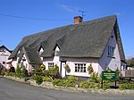 More images |
| The Manor House | Thrandeston | House | C20 | 17 November 1987 | TM1121076393 52°20′42″N 1°05′58″E / 52.344916°N 1.099349°E / 52.344916; 1.099349 (The Manor House) | 1182711 | Upload Photo |
| Manor Farm House | Thurston | Farmhouse | 1876 | 11 January 1991 | TL9272265642 52°15′19″N 0°49′20″E / 52.255183°N 0.822154°E / 52.255183; 0.822154 (Manor Farm House) | 1032401 | Upload Photo |
| Church of St George | Thwaite | Church (redundant) | Medieval | 29 July 1955 | TM1135868153 52°16′15″N 1°05′47″E / 52.270888°N 1.096349°E / 52.270888; 1.096349 (Church of St George) | 1032261 | 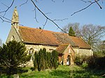 More images |
| Church of St Margaret | Wattisfield | Church | Early 14th century | 15 November 1954 | TM0103074191 52°19′44″N 0°56′56″E / 52.328969°N 0.9488°E / 52.328969; 0.9488 (Church of St Margaret) | 1182475 |  More images |
| Wattisfield Hall, Garden Walls and Gate Piers | Wattisfield | Farmhouse | Early 17th century | 15 November 1954 | TM0083473872 52°19′34″N 0°56′45″E / 52.326176°N 0.945738°E / 52.326176; 0.945738 (Wattisfield Hall, Garden Walls and Gate Piers) | 1352541 |  More images |
| Rookery Farmhouse | Westhorpe | House | 16th century | 29 July 1955 | TM0440769170 52°16′58″N 0°59′43″E / 52.282644°N 0.995241°E / 52.282644; 0.995241 (Rookery Farmhouse) | 1352097 | Upload Photo |
| Rookyard Farmhouse | Base Green, Wetherden | Farmhouse | Late 15th century or Early 16th century | 15 March 1988 | TM0151863380 52°13′54″N 0°56′58″E / 52.231725°N 0.949496°E / 52.231725; 0.949496 (Rookyard Farmhouse) | 1032668 | Upload Photo |
| Church of St Andrew | Weybread | Parish Church | Medieval | 29 July 1955 | TM2410280117 52°22′24″N 1°17′27″E / 52.373228°N 1.290772°E / 52.373228; 1.290772 (Church of St Andrew) | 1284449 | 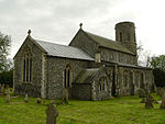 More images |
| Street Farmhouse | Wickham Skeith | Farmhouse | 16th century | 29 July 1955 | TM0887569728 52°17′10″N 1°03′40″E / 52.285975°N 1.060988°E / 52.285975; 1.060988 (Street Farmhouse) | 1352524 |  More images |
| Chesnut Lodge | Wilby Green, Wilby | Farmhouse | 16th century | 29 July 1955 | TM2410770842 52°17′24″N 1°17′05″E / 52.289979°N 1.284667°E / 52.289979; 1.284667 (Chesnut Lodge) | 1181729 | Upload Photo |
| White House | Wingfield | House | Early 17th century | 21 October 1987 | TM2372276549 52°20′29″N 1°16′58″E / 52.341359°N 1.282823°E / 52.341359; 1.282823 (White House) | 1032893 | Upload Photo |
| Wingfield College | Wingfield | College/House | Post 1362 | 29 July 1955 | TM2301576762 52°20′37″N 1°16′21″E / 52.343559°N 1.272604°E / 52.343559; 1.272604 (Wingfield College) | 1284374 | 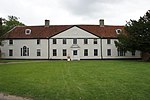 More images |
| Church of St Andrew | Winston | Parish Church | Probably Early 15th century | 9 December 1955 | TM1802561635 52°12′35″N 1°11′23″E / 52.209779°N 1.189701°E / 52.209779; 1.189701 (Church of St Andrew) | 1182799 |  More images |
| The Lanes | Woolpit | House | 19th century | 18 April 1988 | TL9848961644 52°13′02″N 0°54′15″E / 52.217237°N 0.904185°E / 52.217237; 0.904185 (The Lanes) | 1032557 | Upload Photo |
| Worlingworth Hall | Worlingworth | Manor House | Late 13th century | 23 June 1988 | TM2359368960 52°16′24″N 1°16′33″E / 52.273297°N 1.275897°E / 52.273297; 1.275897 (Worlingworth Hall) | 1032363 | Upload Photo |
| The Manor House | Wortham | House | 18th century | 29 July 1955 | TM0782379749 52°22′35″N 1°03′06″E / 52.376337°N 1.051778°E / 52.376337; 1.051778 (The Manor House) | 1032738 | Upload Photo |
| Grange Farm House | Wyverstone | House | 15th century | 29 July 1955 | TM0311968070 52°16′24″N 0°58′33″E / 52.273245°N 0.975724°E / 52.273245; 0.975724 (Grange Farm House) | 1284925 | Upload Photo |
| Bull's Hall and attached Outbuildings | Yaxley | House | 19th century | 14 June 1987 | TM1171473068 52°18′54″N 1°06′17″E / 52.314873°N 1.104644°E / 52.314873; 1.104644 (Bull's Hall and attached Outbuildings) | 1033119 | Upload Photo |
| Guildhall Cottage | Yaxley | Guildhall | Early 16th century | 29 July 1955 | TM1210174096 52°19′26″N 1°06′39″E / 52.323952°N 1.110961°E / 52.323952; 1.110961 (Guildhall Cottage) | 1033115 | Upload Photo |
| Yaxley Hall | Yaxley | Country House | c. 1580 | 14 June 1987 | TM1247273594 52°19′09″N 1°06′58″E / 52.319302°N 1.116079°E / 52.319302; 1.116079 (Yaxley Hall) | 1284876 |  More images |
| Yaxley Manor House | Yaxley | Farmhouse | c. 1520 | 29 July 1955 | TM1082274475 52°19′40″N 1°05′33″E / 52.327847°N 1.09246°E / 52.327847; 1.09246 (Yaxley Manor House) | 1352106 | 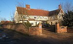 More images |
Notes
- ^ The date given is the date used by Historic England as significant for the initial building or that of an important part in the structure's description.
- ^ Sometimes known as OSGB36, the grid reference is based on the British national grid reference system used by the Ordnance Survey.
- ^ The "List Entry Number" is a unique number assigned to each listed building and scheduled monument by Historic England.
External links
- v
- t
- e
- Bedfordshire
- Berkshire
- Bristol
- Buckinghamshire
- Cambridgeshire
- Cheshire
- Cornwall
- Cumbria
- Derbyshire
- Devon
- Dorset
- Durham
- East Sussex
- East Riding of Yorkshire
- Essex
- Gloucestershire
- Greater London
- Greater Manchester
- Hampshire
- Herefordshire
- Hertfordshire
- Isle of Wight
- Kent
- Lancashire
- Leicestershire
- Lincolnshire
- Merseyside
- Norfolk
- North Yorkshire
- Northamptonshire
- Northumberland
- Nottinghamshire
- Oxfordshire
- Rutland
- Shropshire
- Somerset
- South Yorkshire
- Staffordshire
- Suffolk
- Surrey
- Tyne and Wear
- Warwickshire
- West Midlands
- West Sussex
- West Yorkshire
- Wiltshire
- Worcestershire
- Allerdale
- Amber Valley
- Ashford
- Babergh
- Barrow-in-Furness
- Basildon
- Basingstoke and Deane
- Bath and North East Somerset
- Bolsover
- Boston
- Bournemouth
- Bradford
- Braintree
- Breckland
- Brentwood
- Brighton and Hove
- Bristol
- Broadland
- Calderdale
- Cambridge
- Camden
- Canterbury
- Carlisle
- Castle Point
- Chelmsford
- Cheltenham
- Cherwell
- Cheshire East
- Cheshire West and Chester
- Chesterfield
- Chiltern
- Christchurch
- Colchester
- Copeland
- Corby
- Cotswold
- Dartford
- Daventry
- Dover
- East Cambridgeshire
- Exeter
- Mendip
- North Somerset
- North Yorkshire (district)
- Poole
- Sedgemoor
- South Somerset
- Stoke-on-Trent
- Taunton Deane
- West Somerset
- York


