Goulburn County
Map all coordinates using OpenStreetMap
Download coordinates as:
- KML
- GPX (all coordinates)
- GPX (primary coordinates)
- GPX (secondary coordinates)
Cadastral in New South Wales, Australia
| Goulburn New South Wales | |||||||||||||||
|---|---|---|---|---|---|---|---|---|---|---|---|---|---|---|---|
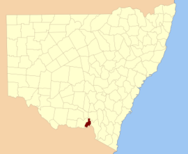 Location in New South Wales | |||||||||||||||
| |||||||||||||||

Goulburn County is one of the 141 cadastral divisions of New South Wales. It contains the city of Albury, and the towns of Jindera, Bowna and Woomargama.
Goulburn County was named in honour of the statesman, Henry Goulburn (1784-1856).[1]
Parishes within this county
A full list of parishes found within this county; their current LGA and mapping coordinates to the approximate centre of each location is as follows:
| Parish | LGA | Coordinates |
|---|---|---|
| Albury | City of Albury | 36°02′54″S 146°54′04″E / 36.04833°S 146.90111°E / -36.04833; 146.90111 (Albury) |
| Back Creek | Greater Hume Shire Council | 35°37′54″S 147°21′04″E / 35.63167°S 147.35111°E / -35.63167; 147.35111 (Back Creek) |
| Billabung | Greater Hume Shire Council | 35°37′54″S 147°30′04″E / 35.63167°S 147.50111°E / -35.63167; 147.50111 (Billabung) |
| Bowna | Greater Hume Shire Council | 35°59′54″S 146°03′04″E / 35.99833°S 146.05111°E / -35.99833; 146.05111 (Bowna) |
| Carabobala | Greater Hume Shire Council | 35°40′54″S 147°15′04″E / 35.68167°S 147.25111°E / -35.68167; 147.25111 (Carabobala) |
| Carabost | Greater Hume Shire Council | 35°35′54″S 147°33′04″E / 35.59833°S 147.55111°E / -35.59833; 147.55111 (Carabost) |
| Coocook | Greater Hume Shire Council | 35°43′54″S 147°33′04″E / 35.73167°S 147.55111°E / -35.73167; 147.55111 (Coocook) |
| Cookardinia | Greater Hume Shire Council | 35°35′54″S 147°15′04″E / 35.59833°S 147.25111°E / -35.59833; 147.25111 (Cookardinia) |
| Coppabella | Greater Hume Shire Council | 35°44′54″S 147°42′04″E / 35.74833°S 147.70111°E / -35.74833; 147.70111 (Coppabella) |
| Cumboroona | Greater Hume Shire Council | 35°58′54″S 147°12′04″E / 35.98167°S 147.20111°E / -35.98167; 147.20111 (Cumboroona) |
| Currajong | Greater Hume Shire Council | 35°50′54″S 147°38′04″E / 35.84833°S 147.63444°E / -35.84833; 147.63444 (Currajong) |
| Dora Dora | Greater Hume Shire Council | 35°51′54″S 147°23′04″E / 35.86500°S 147.38444°E / -35.86500; 147.38444 (Dora Dora) |
| Forest Creek | Greater Hume Shire Council | 35°34′54″S 147°30′04″E / 35.58167°S 147.50111°E / -35.58167; 147.50111 (Forest Creek) |
| Gerogery | Greater Hume Shire Council | 35°52′24″S 147°01′04″E / 35.87333°S 147.01778°E / -35.87333; 147.01778 (Gerogery) |
| Holbrook | Greater Hume Shire Council | 35°42′54″S 147°20′04″E / 35.71500°S 147.33444°E / -35.71500; 147.33444 (Holbrook) |
| Hume | Greater Hume Shire Council | 35°52′54″S 147°15′04″E / 35.88167°S 147.25111°E / -35.88167; 147.25111 (Hume) |
| Huon | Greater Hume Shire Council | 35°52′54″S 146°55′04″E / 35.88167°S 146.91778°E / -35.88167; 146.91778 (Huon) |
| Jergyle | Greater Hume Shire Council | 35°48′54″S 147°23′04″E / 35.81500°S 147.38444°E / -35.81500; 147.38444 (Jergyle) |
| Jerra Jerra | Greater Hume Shire Council | 35°28′54″S 147°13′04″E / 35.48167°S 147.21778°E / -35.48167; 147.21778 (Jerra Jerra) |
| Jindera | Greater Hume Shire Council | 35°57′54″S 146°55′04″E / 35.96500°S 146.91778°E / -35.96500; 146.91778 (Jindera) |
| Jingellic | Greater Hume Shire Council | 35°54′54″S 147°39′04″E / 35.91500°S 147.65111°E / -35.91500; 147.65111 (Jingellic) |
| Little Billabung | Greater Hume Shire Council | 35°29′54″S 147°31′04″E / 35.49833°S 147.51778°E / -35.49833; 147.51778 (Little Billabung) |
| Mitchell | Greater Hume Shire Council | 35°47′54″S 147°18′04″E / 35.79833°S 147.30111°E / -35.79833; 147.30111 (Mitchell) |
| Mountain Creek | Greater Hume Shire Council | 35°46′54″S 147°15′04″E / 35.78167°S 147.25111°E / -35.78167; 147.25111 (Mountain Creek) |
| Mullengandra | Greater Hume Shire Council | 35°53′54″S 147°11′04″E / 35.89833°S 147.18444°E / -35.89833; 147.18444 (Mullengandra) |
| Mungabarina | Greater Hume Shire Council | 35°01′54″S 146°57′04″E / 35.03167°S 146.95111°E / -35.03167; 146.95111 (Mungabarina) |
| Murray | Greater Hume Shire Council | 35°37′24″S 147°32′04″E / 35.62333°S 147.53444°E / -35.62333; 147.53444 (Murray) |
| Narra Narra Wa | Greater Hume Shire Council | 35°47′54″S 147°32′04″E / 35.79833°S 147.53444°E / -35.79833; 147.53444 (Narra Narra Wa) |
| Pulletop | Greater Hume Shire Council | 35°33′54″S 147°21′04″E / 35.56500°S 147.35111°E / -35.56500; 147.35111 (Pulletop) |
| Talmalmo | Greater Hume Shire Council | 35°51′54″S 147°33′04″E / 35.86500°S 147.55111°E / -35.86500; 147.55111 (Talmalmo) |
| Thurgoona | City of Albury | 36°03′54″S 147°00′04″E / 36.06500°S 147.00111°E / -36.06500; 147.00111 (Thurgoona) |
| Vautier | Greater Hume Shire Council | 35°51′54″S 147°30′04″E / 35.86500°S 147.50111°E / -35.86500; 147.50111 (Vautier) |
| Wagra | Greater Hume Shire Council | 35°58′54″S 147°15′04″E / 35.98167°S 147.25111°E / -35.98167; 147.25111 (Wagra) |
| Woomargama | Greater Hume Shire Council | 35°48′54″S 147°10′04″E / 35.81500°S 147.16778°E / -35.81500; 147.16778 (Woomargama) |
| Wyndham | Greater Hume Shire Council | 35°56′54″S 147°07′04″E / 35.94833°S 147.11778°E / -35.94833; 147.11778 (Wyndham) |
| Yambla | Greater Hume Shire Council | 35°55′54″S 147°01′04″E / 35.93167°S 147.01778°E / -35.93167; 147.01778 (Yambla) |
| Yarara | Greater Hume Shire Council | 35°41′54″S 147°39′04″E / 35.69833°S 147.65111°E / -35.69833; 147.65111 (Yarara) |
| Yarra Yarra | Greater Hume Shire Council | 35°42′54″S 147°27′04″E / 35.71500°S 147.45111°E / -35.71500; 147.45111 (Yarra Yarra) |
References
- ^ "Goulburn County". Geographical Names Register (GNR) of NSW. Geographical Names Board of New South Wales.


