Gellicum
Village in Gelderland, Netherlands

Flag

Coat of arms
51°52′34″N 5°9′17″E / 51.87611°N 5.15472°E / 51.87611; 5.15472
(2021)[1]
4155[1]
Gellicum is a village in the Dutch province of Gelderland. It is a part of the municipality of West Betuwe, and lies about 13 km east of Gorinchem.
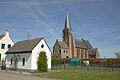
It was first mentioned in the 10th to 11th century Gallinghe(m), and means "settlement of the people of Gallo (person)".[3] Gellicum developed as a stretched out esdorp perpendicular to the dike of the Linge. The tower of the Roman Catholic Church dates from the 13th century and has been enlarged in the 15th century. The church dates from the 14th century. The court house has been built in 1630 attached to the church. The Dutch Reformed Church was originally built in 1823, but burnt down and replaced in 1929.[4] In 1840, it was home to 340 people.[5]
Gallery
-
 Dutch Reformed Church
 -
 Villa in Gellicum
 -
 House in Gellicum
 -
 Street view


References
- ^ a b c "Kerncijfers wijken en buurten 2021". Central Bureau of Statistics. Retrieved 25 March 2022.
two entries
- ^ "Postcodetool for 4155BA". Actueel Hoogtebestand Nederland (in Dutch). Het Waterschapshuis. Retrieved 25 March 2022.
- ^ "Gellicum - (geografische naam)". Etymologiebank (in Dutch). Retrieved 25 March 2022.
- ^ Ronald Stenvert & Sabine Broekhoven (2000). "Gellicum" (in Dutch). Zwolle: Waanders. ISBN 90 400 9406 3. Retrieved 25 March 2022.
- ^ "Gellicum". Plaatsengids (in Dutch). Retrieved 25 March 2022.
Wikimedia Commons has media related to Gellicum.
 | This Gelderland location article is a stub. You can help Wikipedia by expanding it. |
- v
- t
- e


