Fort Dupont
Neighborhood in Washington, D.C.
Place in the United States
Fort Dupont | |
|---|---|
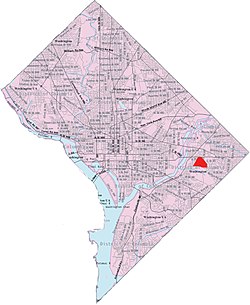 Fort Dupont within the District of Columbia | |
| Country | United States |
| District | Washington, D.C. |
| Ward | Ward 7 |
| Government | |
| • Councilmember | Vincent C. Gray |

Fort Dupont is a residential neighborhood located in southeast Washington, D.C., east of the Anacostia River. It is bounded by East Capitol Street to the north, Fort Dupont Park to the south, Minnesota Avenue to the west, and Fort Chaplin Park to the east and northeast. Fort Dupont has a population of approximately 7,050.[1]
Fort Dupont is adjacent to Fort Dupont Park, the grounds of a Civil War-era fort that was constructed for the defense of Washington. Fort Dupont is a distinct neighborhood from the nearby Dupont Park, although both border the park and take their name from it.
See also
Footnotes
- ^ "Fort Dupont". niche.com. Retrieved June 7, 2021.
Places adjacent to Fort Dupont | ||||||||||||||||
|---|---|---|---|---|---|---|---|---|---|---|---|---|---|---|---|---|
| ||||||||||||||||


- v
- t
- e
- Adams Morgan
- Columbia Heights
- Kalorama Triangle
- Lanier Heights
- LeDroit Park
- Meridian Hill
- Mount Pleasant
- Park View
- Pleasant Plains
- U Street Corridor (Cardozo/Shaw)
- Woodley Park
- Burleith
- Chinatown
- Downtown
- Dupont Circle
- Foggy Bottom
- Georgetown
- Sheridan-Kalorama
- Logan Circle
- Mount Vernon Square
- Penn Quarter
- Shaw
- Southwest Federal Center
- West End
- American University Park
- Berkley
- Cathedral Heights
- Chevy Chase
- Cleveland Park
- Colony Hill
- Forest Hills
- Foxhall
- Friendship Heights
- Glover Park
- Kent
- Massachusetts Heights
- McLean Gardens
- North Cleveland Park
- Observatory Circle
- The Palisades
- Potomac Heights
- Spring Valley
- Tenleytown
- Wakefield
- Wesley Heights
- Woodland Normanstone
- Woodley Park
- Barnaby Woods
- Brightwood
- Brightwood Park
- Chevy Chase
- Colonial Village
- Crestwood
- Fort Stevens Ridge
- Fort Totten
- Hawthorne
- Manor Park
- North Portal Estates
- Petworth
- Queens Chapel
- Riggs Park
- Shepherd Park
- Sixteenth Street Heights
- Takoma
- Arboretum
- Bloomingdale
- Brentwood
- Brookland
- Carver Langston
- Eckington
- Edgewood
- Fort Lincoln
- Fort Totten
- Gateway
- Ivy City
- Langdon
- Michigan Park
- North Michigan Park
- Pleasant Hill
- Queens Chapel
- Stronghold-Metropolis View
- Trinidad
- Truxton Circle
- Woodridge
- Barney Circle
- Capitol Hill
- Judiciary Square
- Mount Vernon Triangle
- Near Northeast
- NoMa
- Southwest Waterfront
- Sursum Corda
- Swampoodle
- Benning
- Benning Heights
- Benning Ridge
- Burrville
- Capitol View
- Central Northeast
- Civic Betterment
- Deanwood
- Dupont Park
- East River Heights
- Eastland Gardens
- Fairfax Village
- Fort Davis
- Fort Dupont
- Fort Stanton
- Good Hope
- Greenway
- Hillbrook
- Hillcrest
- Kenilworth
- Kingman Park
- Lincoln Heights
- Marshall Heights
- Mayfair
- Naylor Gardens
- Northeast Boundary
- Penn Branch
- Randle Highlands
- River Terrace
- Twining
- Anacostia
- Barry Farm
- Bellevue
- Buena Vista
- Congress Heights
- Douglass
- Fairlawn
- Garfield Heights
- Navy Yard
- Park Naylor
- Shipley Terrace
- Skyland
- Washington Highlands
- Woodland
38°53′13″N 76°56′55″W / 38.887°N 76.9485°W / 38.887; -76.9485
 | This article about a location in Washington, D.C., is a stub. You can help Wikipedia by expanding it. |
- v
- t
- e


