Doha Bay
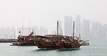


Doha Bay is the semicircular bay bordering Qatar's capital city, Doha. The city was established on the south bank of the bay.[1] Landfill has been used to extend and expand the city to the north around the edge of the bay.[1] Doha Port, Corniche Street and the Doha Corniche, Al Rumaila Park and Sheraton Park border the bay. Palm Tree Island is located in the center of the bay.
Description
The United States Hydrographic Office offers a brief description of the bay in 1920: "The shore of the bay from Al Bida turns northward, and is fronted by an extensive reef running out nearly 1¾ miles, which nearly dries. Between this reef and Jazirat as Safla is a narrow channel leading into a basin westward of that island, with from 1½ to 3½ fathoms water."[2]
Sharq Crossing
In 2011, the Sharq Crossing project (formerly known as Doha Bay Crossing) was announced by the Ministry of Municipal Affairs and Urban Planning.[3] Overseen by Ashghal (Public Works Authority),[4] the project plans to construct three interconnected bridges, designed by Santiago Calatrava, over a 10 km crossing connecting West Bay with Hamad International Airport.[5] There will also be two tunnels below the bay.[6] The purpose behind launching the Sharq Crossing programme was to accommodate the rising traffic in Doha and as a preparatory project for the 2022 FIFA World Cup.[5]
In January 2015, a delay in the $12 billion project was reported. The financial strain of low oil prices may be part of reason for the delay; meanwhile $140 billion is being allocated for other infrastructure ahead of the World Cup event.[6]
References
Wikimedia Commons has media related to Doha Bay.
- ^ a b Doha's Interface with Doha Bay Archived 2015-07-10 at the Wayback Machine Archnet
- ^ United States Hydrographic Office (1920). Persian Gulf Pilot: Comprising the Persian Gulf, the Gulf of Omán and the Makrán Coast. U.S. Government Printing Office. p. 116. This article incorporates text from this source, which is in the public domain.
- ^ "Newly posted designs revive talk of Doha Bay Crossing, but project still far from reality". Doha News. 21 April 2014. Retrieved 9 July 2015.
- ^ "Sharq Crossing Programme". Ashghal. Archived from the original on 22 December 2015. Retrieved 15 December 2015.
- ^ a b Katherine Allen (24 December 2013). "Calatrava's "Sharq Crossing" Planned for Doha Skyline". Archdaily.com. Retrieved 9 July 2015.
- ^ a b Qatar: $12bn Sharq Crossing programme delayed January 21, 2015 Construction Week Online
- v
- t
- e
Municipality of Ad-Dawhah topics
- Al Bidda
- Battle of Al Wajbah
- Isa bin Tarif
- Mohammed bin Thani
- Qatari–Bahraini War
- Timeline of Doha
- Ad-Dawhah Municipality
- Amiri Diwan of the State of Qatar
- Zone 4
- Zone 5
- Zone 6
- Zone 7
- Zone 13
- Zone 14
- Zone 15
- Zone 16
- Zone 17
- Zone 18
- Zone 20
- Zone 21
- Zone 22
- Zone 23
- Zone 24
- Zone 25
- Zone 26
- Zone 27
- Zone 28
- Zone 30
- Zone 31
- Zone 32
- Zone 33
- Zone 34
- Zone 35
- Zone 36
- Zone 37
- Zone 38
- Zone 39
- Zone 40
- Zone 41
- Zone 42
- Zone 43
- Zone 44
- Zone 45
- Zone 46
- Zone 47
- Zone 48
- Zone 49
- Zone 50
- Zone 57
- Zone 58
- Zone 61
- Zone 63
- Zone 64
- Zone 65
- Zone 66
- Zone 67
- Zone 68
| Census-designated districts | |
|---|---|
| District centers |
|
- Al Safliya Island
- Banana Island
- Doha Bay
- Doha Corniche
- Halul Island
- The Pearl Island
transport
- Al Dafna Financial District
- Barwa Financial District
- Doha International Airport
- Doha Metro
- Gold Line
- Hamad International Airport
- Orbital Highway
and culture
- Carnegie Mellon University in Qatar
- Georgetown University School of Foreign Service in Qatar
- Hamad Bin Khalifa University
- Cornell University in Qatar
- HEC Paris in Qatar
- Northwestern University in Qatar
- Texas A&M University at Qatar
- UCL Qatar
- Virginia Commonwealth University in Qatar
- Weill Cornell Medical College in Qatar
- Stenden University Qatar
- College of the North Atlantic in Qatar
- Qatar University in Qatar
- University of Calgary in Qatar
- See also Education City
| Venues | |
|---|---|
| Clubs |
|
25°18′18″N 51°32′17″E / 25.305°N 51.538°E / 25.305; 51.538


