Claremont Colony, South Dakota
Census-designated place in South Dakota, United States
44°42′42″N 96°57′5″W / 44.71167°N 96.95139°W / 44.71167; -96.95139[1]
(2020)[2]
57223 (Castlewood)
Claremont Colony is a Hutterite colony[4] and census-designated place (CDP) in Hamlin County, South Dakota, United States. The population was 68 at the 2020 census.[5] It was first listed as a CDP prior to the 2020 census.[3]
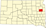
It is in the eastern part of the county, 4 miles (6 km) east of Castlewood and 5 miles (8 km) southwest of Exit 164 (South Dakota Highway 22) on Interstate 29.
Demographics
| Census | Pop. | Note | %± |
|---|---|---|---|
| 2020 | 68 | — | |
| U.S. Decennial Census[6] | |||
References
- ^ "ArcGIS REST Services Directory". United States Census Bureau. Retrieved October 15, 2022.
- ^ "Census Population API". United States Census Bureau. Retrieved October 15, 2022.
- ^ a b "Claremont Colony Census Designated Place". Geographic Names Information System. United States Geological Survey, United States Department of the Interior.
- ^ Friesen, Bert (May 2021). "Claremont Hutterite Colony (Castlewood, South Dakota, USA)". Global Anabaptist Mennonite Encyclopedia Online. Retrieved September 15, 2021.
- ^ "U.S. Census Bureau: Claremont Colony CDP, South Dakota". www.census.gov. United States Census Bureau. Retrieved June 27, 2022.
- ^ "Census of Population and Housing". Census.gov. Retrieved June 4, 2016.
- v
- t
- e
Municipalities and communities of Hamlin County, South Dakota, United States
County seat: Hayti
- Claremont Colony
- Lake Poinsett‡
- Poinsett Colony
‡This populated place also has portions in an adjacent county or counties
- South Dakota portal
- United States portal
 | This South Dakota state location article is a stub. You can help Wikipedia by expanding it. |
- v
- t
- e


