Cave Knoll
Mountain in Utah, United States


Cave Knoll
Location in Utah
Show map of Utah
Cave Knoll
Cave Knoll (the United States)
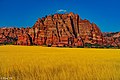
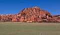
Show map of the United StatesCave Knoll is a 6,486-foot (1,977 m) summit located in Zion National Park, in Washington County of southwest Utah, United States.[3] Cave Knoll, a formation composed of Navajo Sandstone, is situated in Cave Valley, 11.5 mi (18.5 km) northwest of Springdale, Utah. Its neighbors include Pine Valley Peak, 1.7 mi (3 km) to the northeast, Tabernacle Dome, 1.6 mi (3 km) to the south-southeast, and North Guardian Angel, 2.5 mi (4 km) to the east. Precipitation runoff from this mountain drains into tributaries of the Virgin River. Access to this peak is via the Kolob Terrace Road. This peak's name was officially adopted in 1934 by the U.S. Board on Geographic Names.[3]
Climate
Spring and fall are the most favorable seasons to visit Cave Knoll. According to the Köppen climate classification system, it is located in a Cold semi-arid climate zone, which is defined by the coldest month having an average mean temperature below 32 °F (0 °C), and at least 50% of the total annual precipitation being received during the spring and summer. This desert climate receives less than 10 inches (250 millimeters) of annual rainfall, and snowfall is generally light during the winter.[4]
Gallery
-
 Cave Knoll
 -

-


See also
 Mountains portal
 Utah portal


