Bristol Head


Bristol Head
Location in Colorado
Show map of Colorado
Bristol Head
Bristol Head (the United States)
Show map of the United StatesSan Juan Mountains[3]
Bristol Head is a 12,712-foot-elevation (3,875-meter) mountain summit in Mineral County, Colorado, United States.
Description
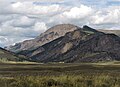
Bristol Head is located eight miles (13 km) southwest of the community of Creede, on land managed by Rio Grande National Forest. It is situated east of the Continental Divide in the San Juan Mountains which are a subrange of the Rocky Mountains. Precipitation runoff from the mountain drains into the Rio Grande and topographic relief is significant as the summit rises 3,900 feet (1,200 meters) above the river in three miles (4.8 km) and 3,250 feet (990 meters) above Santa Maria Reservoir in 1.2 mile (1.9 km). Access to the summit is via a 15-mile 4WD road which reaches a radio repeater at the top.[5] The mountain's toponym has been officially adopted by the United States Board on Geographic Names,[2] and was recorded in publications as early as 1876 since the peak served as a triangulation station for the Wheeler Survey.[6]
Climate
According to the Köppen climate classification system, Bristol Head is located in an alpine subarctic climate zone with cold, snowy winters, and cool to warm summers.[7] Due to its altitude, it receives precipitation all year, as snow in winter and as thunderstorms in summer, with a dry period in late spring. Hikers can expect afternoon rain, hail, and lightning from the seasonal monsoon in late July and August.
Gallery
-
 Northwest aspect viewed from North Clear Creek Falls overlook
 -
 South aspect
 -
 Bristol Head in 1874 by William Henry Jackson


See also
- San Juan volcanic field
 Mountains portal
- Mountains of Mineral County, Colorado

References
- ^ a b c d e "Bristol Head - 12,712' CO". listsofjohn.com. Retrieved July 9, 2023.
- ^ a b "Bristol Head". Geographic Names Information System. United States Geological Survey, United States Department of the Interior. Retrieved July 9, 2023.
- ^ "Bristol Head, Colorado". Peakbagger.com. Retrieved July 9, 2023.
- ^ a b Geologic map of the Bristol Head Quadrangle, Mineral and Hinsdale Counties, Colorado, Thomas A. Steven, U.S. Geological Survey, 1967.
- ^ The Best of Colorado 4-wheel Drive Roads, Adler Publishing (2007), ISBN 9780930657406, p. 155.
- ^ George Montague Wheeler (1876), Annual Report Upon the Geographical Explorations and Surveys West of the One Hundredth Meridian, US Government Printing Office, p. 89.
- ^ Peel, M. C.; Finlayson, B. L.; McMahon, T. A. (2007). "Updated world map of the Köppen−Geiger climate classification". Hydrol. Earth Syst. Sci. 11. ISSN 1027-5606.
External links
- Weather forecast: Bristol Head
- National Geodetic Survey Data Sheet
- Bristol Head (photo): Flickr
- v
- t
- e
Places adjacent to Bristol Head
| Table Mountain | Creede | |
 | ||
| Santa Maria Reservoir |  Bristol Head Bristol Head | Rio Grande |
 | ||
| Silver Thread Byway |


