Bregenzer Ach
River in Vorarlberg, Austria
| Bregenzer Ach | |
|---|---|
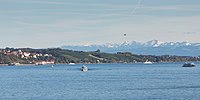
 Mouth of the river on Upper Lake Constance | |
| Location | |
| Country | Austria |
| State | Vorarlberg |
| Physical characteristics | |
| Source | |
| • location | Mohnenfluh in the Bregenz Forest Mountains near Schröcken |
| • elevation | 2,400 m (7,900 ft) |
| Mouth | |
• location | Lake Constance at Hard |
• coordinates | 47°30′12″N 9°41′37″E / 47.50333°N 9.69361°E / 47.50333; 9.69361 |
• elevation | 395 m (1,296 ft) |
| Length | 67.0 km (41.6 mi) [1] |
| Basin size | 832 km2 (321 sq mi) [1] |
| Basin features | |
| Progression | Lake Constance→ Rhine→ North Sea |
| Tributaries | |
| • right | Weißach, Subersach |
The Bregenzer Ach (also: Bregenzer Ache) is the main river of the Bregenz Forest (Bregenzerwald) in the Austrian state of Vorarlberg. It is a tributary to Lake Constance and the River Rhine, respectively.
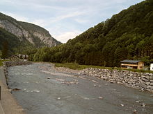

Geography
The source of the river is above the town of Schröcken, at an altitude of about 2,400 m (7,900 ft).[2] The river is 67 km (42 mi) long and drains almost the entire area of the Bregenz Forest. Its mouth on Upper Lake Constance (Obersee) is near Bregenz and lies east of the outflows of the rivers Dornbirner Ach and Alpine Rhine. The outflow of Lake Constance is the High Rhine.
See also
References
- ^ a b Complete table of the Bavarian Waterbody Register by the Bavarian State Office for the Environment (xls, 10.3 MB)
- ^ "Bregenzer Ach in Österreich, Vorarlberg - alpen-guide.de". www.alpen-guide.de. Retrieved 2 March 2022.
Wikimedia Commons has media related to Bregenzer Ache.
- v
- t
- e
Tributaries of the Rhine
- Vorderrhein
- Aua da Russein
- Schmuèr
- Alpine Rhine
- Vorderrhein
- Tamina
- Saar
- Alter Rhein
- Rheintaler Binnenkanal
- Upper Lake Constance
- Goldach
- Aach (Arbon)
- Aach (Romanshorn)
- Seerhein
- Grenzbach
- Dorfbach
- Lower Lake Constance
- Anderbach
- High Rhine
- Thur
- Töss
- Glatt
- Aare
- Sissle
- Möhlinbach
- Ergolz
- Birs
- Upper Rhine
- Birsig
- Ill
- Moder
- Sauer
- Lauter
- Spiegelbach
- Queich
- Speyerbach
- Rehbach
- Isenach
- Eckbach
- Eisbach
- Pfrimm
- Selz
- Middle Rhine
- Welzbach
- Nahe
- Moselle
- Nette
- Brohlbach
- Ahr
- Lower Rhine
- Erft

- Vorderrhein
- Rein da Tuma
- Rein da Curnera
- Rein da Medel
- Rein da Sumvitg
- Glogn
- Rabiusa
- Hinterrhein
- Ragn da Ferrera
- Albula/Alvra
- Alpine Rhine
- Hinterrhein
- Plessur
- Landquart
- Mülbach
- Liechtenstein inland canal
- Ill
- Frutz
- Upper Lake Constance
- Dornbirner Ach
- Bregenzer Ach
- Leiblach
- Argen
- Schussen
- Rotach
- Brunnisach
- Lipbach
- Seefelder Aach
- Stockacher Aach
- Lower Lake Constance
- Radolfzeller Aach
- High Rhine
- Biber
- Durach
- Wutach
- Alb
- Murg
- Wehra
- Upper Rhine
- Wiese
- Kander
- Elz
- Kinzig
- Rench
- Acher
- Murg
- Alb
- Pfinz
- Saalbach
- Kraichbach
- Leimbach
- Neckar
- Weschnitz
- Modau
- Main
- Middle Rhine
- Wisper
- Lahn
- Wied
- Lower Rhine
- Sieg
- Wupper
- Düssel
- Ruhr
- Emscher
- Lippe
- IJssel
- Oude IJssel/Issel
- Berkel
- Schipbeek


| Authority control databases: National |
|
|---|
 | This Vorarlberg location article is a stub. You can help Wikipedia by expanding it. |
- v
- t
- e
This article related to a river in Austria is a stub. You can help Wikipedia by expanding it. |
- v
- t
- e


