Boissei-la-Lande
Commune in Normandy, France
Location of Boissei-la-Lande

(2020–2026) Yves Grasland[1]
1
(2021)[2]
61049 /61570
(avg. 166 m or 545 ft)
Boissei-la-Lande (French pronunciation: [bwasɛ la lɑ̃d] ⓘ) is a commune in the Orne department in northwestern France.
Geography
The commune is made up of the following collection of villages and hamlets, Le Friche du Val,Thion, Le Theil, La Rivière,Pillou,La Hauteville and Boissei-la-Lande.[3]
Boissei-la-Lande along with another 70 communes is part of a 20,593 hectare, Natura 2000 conservation area, called the Haute vallée de l'Orne et affluents.[4] The area is focused on the sources of the Orne and its main tributaries up to Putanges-Pont-Ecrepin, an area that is prone to flooding and has water all year round.[4][5] The conservation area has thirteen species listed in Annex 2 of the Habitats Directive;[6]
- Eurasian otter
- European bullhead
- Cottus perifretum
- Brook lamprey
- White-clawed crayfish
- Jersey tiger
- Marsh fritillary
- European stag beetle
- Northern crested newt
- Southern damselfly
- Orange-spotted emerald
- Thick shelled river mussel
- Desmoulin's whorl snail
In addition to the Orne river, the commune also has three streams running through it, the Calvaire, L'Epinet and La Gironde.[7]
Neighbouring communes [3] | ||||||||||||||||
|---|---|---|---|---|---|---|---|---|---|---|---|---|---|---|---|---|
| ||||||||||||||||


Population
| Year | Pop. | ±% p.a. |
|---|---|---|
| 1968 | 113 | — |
| 1975 | 103 | −1.31% |
| 1982 | 115 | +1.59% |
| 1990 | 104 | −1.25% |
| 1999 | 115 | +1.12% |
| 2009 | 117 | +0.17% |
| 2014 | 111 | −1.05% |
| 2020 | 121 | +1.45% |
| Source: INSEE[8] | ||
Notable buildings and places
National heritage sites
The Commune has 2 buildings and areas listed as a Monument historique.
- Church Farm a 16th century farmhouse listed as a monument in 1986.[9]
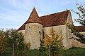
- Church of Boissei-la-Lande a 16th century church listed as a monument in 1986.[10]
-
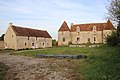 Boissei-la-Lande - Church farm
 -
 Boissei-la-Lande church farm
 -
 Boissei-la-Lande church


See also
References
- ^ "Répertoire national des élus: les maires". data.gouv.fr, Plateforme ouverte des données publiques françaises (in French). 9 August 2021.
- ^ "Populations légales 2021" (in French). The National Institute of Statistics and Economic Studies. 28 December 2023.
- ^ a b "Boissei-la-Lande · 61570, France". Boissei-la-Lande · 61570, France.
- ^ a b "INPN - FSD Natura 2000 - FR2500099 - Haute vallée de l'Orne et affluents - Description".
- ^ "Le site | hautevalleeorne". hautevalleeorne.n2000.fr.
- ^ "EUNIS -Site factsheet for Haute vallée de l'Orne et affluents". eunis.eea.europa.eu.
- ^ Sandre. "Fiche cours d'eau - L'Orne (I2--0200)".
- ^ Population en historique depuis 1968, INSEE
- ^ "Ferme de l'Eglise à Boissei-la-Lande - PA00110747". monumentum.fr.
- ^ "Eglise à Boissei-la-Lande - PA00110746". monumentum.fr.
Wikimedia Commons has media related to Boissei-la-Lande.
- v
- t
- e

- L'Aigle
- Alençonpref
- Almenêches
- Appenai-sous-Bellême
- Argentansubpr
- Les Aspres
- Athis-Val de Rouvre
- Aube
- Aubry-le-Panthou
- Aubusson
- Auguaise
- Aunay-les-Bois
- Aunou-le-Faucon
- Aunou-sur-Orne
- Les Authieux-du-Puits
- Avernes-Saint-Gourgon
- Avoine
- Avrilly
- Bagnoles de l'Orne Normandie
- Bailleul
- Banvou
- Barville
- Bazoches-au-Houlme
- Bazoches-sur-Hoëne
- La Bazoque
- Beaufai
- Beaulieu
- Beauvain
- Belfonds
- Belforêt-en-Perche
- Bellavilliers
- Bellême
- La Bellière
- Bellou-en-Houlme
- Bellou-le-Trichard
- Berd'huis
- Berjou
- Bizou
- Boëcé
- Boischampré
- Boissei-la-Lande
- Boitron
- Bonnefoi
- Bonsmoulins
- Le Bosc-Renoult
- Boucé
- Le Bouillon
- Brethel
- Bretoncelles
- Brieux
- Briouze
- Brullemail
- Buré
- Bures
- Bursard
- Cahan
- Caligny
- Camembert
- Canapville
- Carrouges
- Ceaucé
- Le Cercueil
- Cerisé
- Cerisy-Belle-Étoile
- Ceton
- Chahains
- Chailloué
- Le Chalange
- Champcerie
- Le Champ-de-la-Pierre
- Les Champeaux
- Champeaux-sur-Sarthe
- Champ-Haut
- Champosoult
- Champsecret
- Chandai
- Chanu
- La Chapelle-au-Moine
- La Chapelle-Biche
- La Chapelle-Montligeon
- La Chapelle-près-Sées
- La Chapelle-Souëf
- La Chapelle-Viel
- Charencey
- Le Château-d'Almenêches
- Le Châtellier
- Chaumont
- La Chaux
- Chemilli
- Ciral
- Cisai-Saint-Aubin
- Colombiers
- Comblot
- Commeaux
- Condé-sur-Sarthe
- Corbon
- Coudehard
- Coulimer
- Coulmer
- Coulonces
- La Coulonche
- Coulonges-sur-Sarthe
- Courgeon
- Courgeoût
- Cour-Maugis sur Huisne
- Courtomer
- Craménil
- Croisilles
- Crouttes
- Crulai
- Cuissai
- Dame-Marie
- Damigny
- Domfront en Poiraie
- Dompierre
- Durcet
- Échalou
- Échauffour
- Écorcei
- Écorches
- Écouché-les-Vallées
- Écouves
- Essay
- Faverolles
- Fay
- Feings
- La Ferrière-au-Doyen
- La Ferrière-aux-Étangs
- La Ferrière-Béchet
- La Ferrière-Bochard
- Ferrières-la-Verrerie
- La Ferté-en-Ouche
- La Ferté-Macé
- Flers
- Fleuré
- Fontaine-les-Bassets
- Francheville
- La Fresnaie-Fayel
- Fresnay-le-Samson
- Gacé
- Gandelain
- Gâprée
- Les Genettes
- La Genevraie
- Giel-Courteilles
- Ginai
- Godisson
- La Gonfrière
- Gouffern en Auge
- Le Grais
- Guêprei
- Guerquesalles
- Habloville
- Hauterive
- Héloup
- L'Hôme-Chamondot
- Igé
- Irai
- Joué-du-Bois
- Joué-du-Plain
- Juvigny-sur-Orne
- Juvigny Val d'Andaine
- Lalacelle
- Laleu
- La Lande-de-Goult
- La Lande-de-Lougé
- La Lande-Patry
- La Lande-Saint-Siméon
- Landigou
- Landisacq
- Larré
- Lignères
- Lignou
- Loisail
- Longny les Villages
- Lonlay-l'Abbaye
- Lonlay-le-Tesson
- Lonrai
- Lougé-sur-Maire
- Louvières-en-Auge
- Macé
- La Madeleine-Bouvet
- Le Mage
- Magny-le-Désert
- Mahéru
- Mantilly
- Marchemaisons
- Mardilly
- Mauves-sur-Huisne
- Médavy
- Méhoudin
- Le Mêle-sur-Sarthe
- Le Ménil-Bérard
- Le Ménil-Broût
- Le Ménil-Ciboult
- Le Ménil-de-Briouze
- Ménil-Erreux
- Ménil-Froger
- Ménil-Gondouin
- Le Ménil-Guyon
- Ménil-Hermei
- Ménil-Hubert-en-Exmes
- Ménil-Hubert-sur-Orne
- Le Ménil-Scelleur
- Le Ménil-Vicomte
- Ménil-Vin
- Les Menus
- Le Merlerault
- Merri
- La Mesnière
- Messei
- Mieuxcé
- Moncy
- Montabard
- Montchevrel
- Montgaudry
- Montilly-sur-Noireau
- Montmerrei
- Mont-Ormel
- Montreuil-au-Houlme
- Montreuil-la-Cambe
- Les Monts d'Andaine
- Montsecret-Clairefougère
- Monts-sur-Orne
- Mortagne-au-Perchesubpr
- Mortrée
- La Motte-Fouquet
- Moulins-la-Marche
- Moulins-sur-Orne
- Moutiers-au-Perche
- Neauphe-sous-Essai
- Neauphe-sur-Dive
- Nécy
- Neuilly-le-Bisson
- Neuville-sur-Touques
- Neuvy-au-Houlme
- Nonant-le-Pin
- Occagnes
- Ommoy
- L'Orée-d'Écouves
- Orgères
- Origny-le-Roux
- Pacé
- Parfondeval
- Le Pas-Saint-l'Homer
- Passais Villages
- Perche en Nocé
- Perrou
- Pervenchères
- Le Pin-au-Haras
- Le Pin-la-Garenne
- Planches
- Le Plantis
- Pointel
- Pontchardon
- Pouvrai
- Putanges-le-Lac
- Rai
- Rânes
- Rémalard en Perche
- Le Renouard
- Résenlieu
- Réveillon
- Ri
- Rives d'Andaine
- La Roche-Mabile
- Roiville
- Rônai
- Rouperroux
- Sablons-sur-Huisne
- Sai
- Saint-Agnan-sur-Sarthe
- Saint-André-de-Briouze
- Saint-André-de-Messei
- Saint-Aquilin-de-Corbion
- Saint-Aubin-d'Appenai
- Saint-Aubin-de-Bonneval
- Saint-Aubin-de-Courteraie
- Saint-Bômer-les-Forges
- Saint-Brice
- Saint-Brice-sous-Rânes
- Saint-Céneri-le-Gérei
- Saint-Christophe-de-Chaulieu
- Saint-Clair-de-Halouze
- Saint-Cyr-la-Rosière
- Saint-Denis-sur-Huisne
- Saint-Denis-sur-Sarthon
- Sainte-Céronne-lès-Mortagne
- Sainte-Gauburge-Sainte-Colombe
- Sainte-Honorine-la-Chardonne
- Sainte-Honorine-la-Guillaume
- Saint-Ellier-les-Bois
- Sainte-Marguerite-de-Carrouges
- Sainte-Marie-la-Robert
- Sainte-Opportune
- Sainte-Scolasse-sur-Sarthe
- Saint-Evroult-de-Montfort
- Saint-Evroult-Notre-Dame-du-Bois
- Saint-Fraimbault
- Saint-Fulgent-des-Ormes
- Saint-Georges-d'Annebecq
- Saint-Georges-des-Groseillers
- Saint-Germain-d'Aunay
- Saint-Germain-de-Clairefeuille
- Saint-Germain-de-la-Coudre
- Saint-Germain-de-Martigny
- Saint-Germain-des-Grois
- Saint-Germain-du-Corbéis
- Saint-Germain-le-Vieux
- Saint-Gervais-des-Sablons
- Saint-Gervais-du-Perron
- Saint-Gilles-des-Marais
- Saint-Hilaire-de-Briouze
- Saint-Hilaire-le-Châtel
- Saint-Hilaire-sur-Erre
- Saint-Hilaire-sur-Risle
- Saint-Jouin-de-Blavou
- Saint-Julien-sur-Sarthe
- Saint-Lambert-sur-Dive
- Saint-Langis-lès-Mortagne
- Saint-Léger-sur-Sarthe
- Saint-Léonard-des-Parcs
- Saint-Mard-de-Réno
- Saint-Mars-d'Égrenne
- Saint-Martin-d'Écublei
- Saint-Martin-des-Landes
- Saint-Martin-des-Pézerits
- Saint-Martin-du-Vieux-Bellême
- Saint-Martin-l'Aiguillon
- Saint-Michel-Tubœuf
- Saint-Nicolas-des-Bois
- Saint-Nicolas-de-Sommaire
- Saint-Ouen-de-Sécherouvre
- Saint-Ouen-le-Brisoult
- Saint-Ouen-sur-Iton
- Saint-Patrice-du-Désert
- Saint-Paul
- Saint-Philbert-sur-Orne
- Saint-Pierre-d'Entremont
- Saint-Pierre-des-Loges
- Saint-Pierre-du-Regard
- Saint-Pierre-la-Bruyère
- Saint-Quentin-de-Blavou
- Saint-Quentin-les-Chardonnets
- Saint-Roch-sur-Égrenne
- Saint-Sauveur-de-Carrouges
- Saint-Sulpice-sur-Risle
- Saint-Symphorien-des-Bruyères
- Saires-la-Verrerie
- Le Sap-André
- Sap-en-Auge
- Sarceaux
- Sées
- La Selle-la-Forge
- Semallé
- Sévigny
- Sevrai
- Soligny-la-Trappe
- Suré
- Tanques
- Tanville
- Tellières-le-Plessis
- Tessé-Froulay
- Ticheville
- Tinchebray-Bocage
- Torchamp
- Touquettes
- Tournai-sur-Dive
- Tourouvre au Perche
- Trémont
- La Trinité-des-Laitiers
- Trun
- Val-au-Perche
- Valframbert
- Vaunoise
- Les Ventes-de-Bourse
- La Ventrouze
- Verrières
- Vidai
- Vieux-Pont
- Villedieu-lès-Bailleul
- Villiers-sous-Mortagne
- Vimoutiers
- Vitrai-sous-Laigle
- Les Yveteaux
- pref: prefecture
- subpr: subprefecture
| Authority control databases: National |
|
|---|
 | This Orne geographical article is a stub. You can help Wikipedia by expanding it. |
- v
- t
- e


