Abrams Mountain
Mountain in the state of Colorado


Abrams Mountain
Location in Colorado
Show map of Colorado
Abrams Mountain
Abrams Mountain (the United States)
Show map of the United StatesColorado, US
San Juan Mountains
Abrams Mountain, also known as Mount Abram or Mount Abrams, is a 12,801-foot-elevation (3,902-meter) mountain summit located on the shared boundary of Ouray County with San Juan County in southwest Colorado, United States.[3][4] It is situated four miles south of the town of Ouray, on land managed by Uncompahgre National Forest. It is part of the San Juan Mountains, which are a subset of the Rocky Mountains, and is west of the Continental Divide. Topographic relief is significant as the north aspect rises 3,800 feet (1,200 meters) above Uncompahgre Gorge in 1.5 mile. Historic mines are located on the slopes of Abrams Mountain. This iconic feature of the Ouray landscape can be seen for many miles while driving Highway 550 south from Montrose toward Ouray, and it dominates the San Juan Skyway from Red Mountain Pass to Ironton Park.
Etymology
The mountain's name, which has been officially adopted by the United States Board on Geographic Names, was in use before 1906 when Henry Gannett published it in the Gazetteer of Colorado.[3][5] The name commemorates Abram Cutler (born November 2, 1832), the first judge of Ouray County and notary public who administered the oath to Ouray's original town board. Originally a civil engineer, he assisted Ferdinand Vandeveer Hayden with the 1874 survey of this area, so the possibility exists that Hayden named the mountain to honor Cutler.[4] The nearby Cutler Creek which is just north of Ouray was also named for Abram Cutler, and the Cutler Formation takes its name from the creek.
Climate
According to the Köppen climate classification system, Abrams Mountain is located in an alpine subarctic climate zone with long, cold, snowy winters, and cool to warm summers.[6] Due to its altitude, it receives precipitation all year, as snow in winter, and as thunderstorms in summer, with a dry period in late spring. Precipitation runoff from the mountain drains into the Uncompahgre River.
Gallery
-
 Abrams Mountain
 -
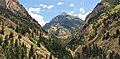
 Abrams Mountain seen from southbound US Highway 550, approaching Ouray.
 -
 Abrams Mountain seen from southbound US Highway 550, approaching Ouray.
 -
 Abrams from Uncompahgre Gorge
 -
 Southwest aspect from the Million Dollar Highway
 -
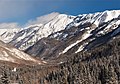 Southwest aspect of Abrams Mountain in winter
 -
 Abrams Mountain seen from Hwy 550 at Cutler Creek. Both the mountain and creek are named after Abram Cutler.
 -
 Abrams Mountain from the Million Dollar Highway
 -
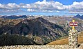 East aspect of Abrams Mountain (centered, shaded) viewed from Odom Point on Engineer Mountain


See also
 Mountains portal
 Colorado portal


- Mountains of Ouray County, Colorado
References
- ^ a b "Abrams Mountain, Colorado". Peakbagger.com.
- ^ a b c "Abrams Mountain - 12,801' CO". listsofjohn.com. Retrieved 2021-07-07.
- ^ a b c "Abrams Mountain". Geographic Names Information System. United States Geological Survey, United States Department of the Interior. Retrieved 2021-07-07.
- ^ a b Robert L. Brown, Colorado on Foot, 2002, Caxton Press, ISBN 0870043366, page 293.
- ^ Henry Gannett, Gazetteer of Colorado, 1906, US Government Printing Office, page 12.
- ^ Peel, M. C.; Finlayson, B. L.; McMahon, T. A. (2007). "Updated world map of the Köppen−Geiger climate classification". Hydrol. Earth Syst. Sci. 11. ISSN 1027-5606.
External links
- Weather forecast: Abrams Mountain
- v
- t
- e

- Mount Garfield
- Aspen Mountain
- Capitol Peak
- Castle Peak
- Cathedral Peak
- Chair Mountain
- Crested Butte
- Gothic Mountain
- Italian Mountain
- Maroon Bells
- Mount Emmons
- Mount Owen
- Mount Sopris
- Pyramid Peak
- Snowmass Mountain
- Snowmass Peak
- Treasure Mountain
- Black Mountain (Moffat County)
- Columbus Mountain
- Elk Mountain (Routt County)
- Hahns Peak
- Flat Top Mountain
- Sleepy Cat Peak
- Eagles Nest
- Jacque Peak
- Meridian Peak
- Mount Powell
- The Spider
- Crater Peak
- North Mamm Peak
- Clark Peak
- Arkansas Hills
- Clinton Peak
- Dyer Mountain
- Gemini Peak
- Horseshoe Mountain
- Mount Arkansas
- Mount Bross
- Mount Buckskin
- Mount Democrat
- Mount Lincoln
- Mount Sheridan
- Mount Sherman
- Pacific Peak
- West Buffalo Peak
- Elk Mountain (Grand County)
- Parkview Mountain
- Radial Mountain
- Whiteley Peak
| Sangre de Cristo Range |
|
|---|---|
| Wet Mountains |
|
| Others |
|
| Collegiate Peaks |
|
|---|---|
| Others |
|
- Crystal Peak
- Fletcher Mountain
- Peak 10
- Peak One
- Quandary Peak
- Tenmile Peak
- Bear Mountain
- Blair Mountain
- Chalk Mountains
- Cochetopa Hills
- Dawson Butte
- Diamond Peak
- Flirtation Peak
- Granite Peak
- Grand Hogback
- Grannys Nipple
- Horsefly Peak
- Lead Mountain (Grand County)
- Mount Neva
- Powell Peak
- San Luis Hills
- Storm King Mountain
- Terrible Mountain
- Two Buttes
- Ute Mountain


