Tabuarorae
| Tabuarorae | |||
|---|---|---|---|
| |||
| Koordinaten | 1° 56′ 32,35″ S, 175° 34′ 34,18″ O-1.94232175.57616Koordinaten: 1° 56′ 32,35″ S, 175° 34′ 34,18″ O | ||
 | |||
| Basisdaten | |||
| Staat | Kiribati | ||
| Inselgruppe | Gilbertinseln | ||
| ISO 3166-2 | KI-G | ||
| Fläche | 0,1 km² | ||
| Einwohner | 223 (2020) | ||
| Dichte | 3.716,7 Ew./km² | ||
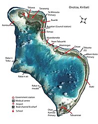 beschriftetes Satellitenbild von Onotoa | |||


Tabuarorae (Taburari) ist ein Ort im südlichen Teil des pazifischen Archipels der Gilbertinseln nahe dem Äquator im Staat Kiribati mit einer Landfläche von 6 Hektar.[1] 2020 wurden 223 Einwohner gezählt.[2]
Geographie
Tabuarorae ist der südlichste Ort auf dem Atoll Onotoa.[3] Im Ort gibt es das Tabuarorae Maneaba, ein traditionelles Versammlungshaus, und eine protestantische Kirche sowie die Otan Kariraia Primary School. In dem breiten Ende des Riffsaums gibt es mehrere Lagunen.
Klima
Das Klima ist tropisch heiß, wird jedoch von ständig wehenden Winden gemäßigt. Ebenso wie die anderen Orte der südlichen Gilbertinseln wird Tabuarorae gelegentlich von Zyklonen heimgesucht.
Einzelnachweise
- ↑ Onotoa Island 2008 Socio-Economic Profile. Band 1. Republic of Kiribati – Ministry of Internal and Social Affairs, 2008, Table 1: Population Density by village (2000 & 2005), S. 18 (englisch, web.archive.org [PDF; 1,6 MB; abgerufen am 30. Juni 2024]).
- ↑ Kiribati – Population and Housing Census 2020. Value 1707. In: microdata.pacificdata.org. Pazifische Gemeinschaft, 25. Juni 2024, abgerufen am 7. September 2024 (englisch).
- ↑ Onotoa (= Republic of Kiribati Island Report Series. Nr. 16). Republic of Kiribati – Office of Te Beretitenti, 2012, Figure 16-2: Map of Onotoa, S. 3 (englisch, web.archive.org [PDF; 599 kB; abgerufen am 30. Juni 2024]).


