Branne (Gironde)
| Branne | ||
|---|---|---|
 |
| |
| Staat | Frankreich | |
| Region | Nouvelle-Aquitaine | |
| Département (Nr.) | Gironde (33) | |
| Arrondissement | Libourne | |
| Kanton | Les Coteaux de Dordogne | |
| Gemeindeverband | Castillon-Pujols | |
| Koordinaten | 44° 52′ N, 0° 11′ W44.859166666667-0.18527777777778Koordinaten: 44° 52′ N, 0° 11′ W | |
| Höhe | 2–81 m | |
| Fläche | 2,41 km² | |
| Einwohner | 1.309 (1. Januar 2021) | |
| Bevölkerungsdichte | 543 Einw./km² | |
| Postleitzahl | 33420 | |
| INSEE-Code | 33071 | |
| Website | https://www.mairie-branne.fr/ | |
 Rathaus (Mairie) von Branne | ||


Branne ist eine französische Gemeinde mit 1.309 Einwohnern (Stand: 1. Januar 2021) im Département Gironde in der Region Nouvelle-Aquitaine; sie gehört zum Arrondissement Libourne und zum Kanton Les Coteaux de Dordogne. Die Einwohner werden Brannais genannt.
Geographie
Branne liegt etwa 35 Kilometer östlich von Bordeaux an der Dordogne. Umgeben wird Branne von den Nachbargemeinden Saint-Sulpice-de-Faleyrens im Norden, Cabara im Osten, Saint-Aubin-de-Branne im Südosten und Süden, Lugaignac im Süden und Südwesten sowie Grézillac im Südwesten und Westen.
Durch die Gemeinde führt die frühere Route nationale 136 (heutige D936).
Bevölkerungsentwicklung
| Jahr | 1962 | 1968 | 1975 | 1982 | 1990 | 1999 | 2010 | 2020 |
| Einwohner | 778 | 750 | 764 | 850 | 875 | 949 | 1294 | 1317 |
| Quellen: Cassini und INSEE | ||||||||
Sehenswürdigkeiten
- Kirche Saint-Étienne
- Friedhofskreuz, errichtet im 17. Jahrhundert
-
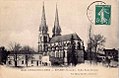 Kirche Saint-Étienne auf einer alten Postkarte
 -
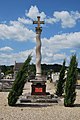 Friedhofskreuz


Literatur
- Le Patrimoine des Communes de la Gironde. Flohic Éditions, Band 1, Paris 2001, ISBN 2-84234-125-2, S. 387–388.
Weblinks
Commons: Branne – Sammlung von Bildern


